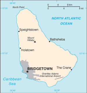
Barbados is a continental island in the North Atlantic Ocean and is located at 13°10' north of the equator, and 59°32' west of the Prime Meridian. As the easternmost isle of the Lesser Antilles in the West Indies, Barbados lies 100 kilometres (62 mi) east of the Windward Islands and Caribbean Sea. The maritime claim for Barbados is a territorial sea of 12 nmi, with an exclusive economic zone of 200 nmi, this gives Barbados a total maritime area of 183,436 km2. Of the total EEZ area 70,000 km2, is set aside for offshore oil exploration. A pending application to UNCLOS has placed for consideration a continental shelf 200 nmi to the east and south. To the west, however, most of Barbados' maritime boundaries consist of median lines with neighbours. These neighbours include: Martinique, and Saint Lucia to the northwest, Saint Vincent and the Grenadines to the west, Trinidad and Tobago and Venezuela to the southwest, and Guyana to the southeast.

Holetown, is a small town located in the Caribbean island nation of Barbados. Holetown is located in the parish of Saint James on the sheltered west coast of the island.
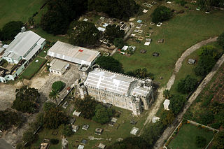
The current Christ Church Parish Church located in Oistins, Christ Church, Barbados was built in 1935 and is the fifth parish church on the site. At various times the previous structures have all been destroyed by natural disasters including flood, fire or hurricanes.

Saint Lawrence Gap, Christ Church is one of the best known neighbourhoods in the country of Barbados. Sometimes just called "The Gap", Saint Lawrence Gap is located on the southern coast of Barbados along the island's Highway 7. Found between Oistins to the east and Worthings to the west, Saint Lawrence Gap features a 1.5k kilometer stretch of bars, hotels, dance clubs, restaurants, inns, resorts, and shops along a white powdery-sand beachfront. It is situated roughly 5 km southeast of the capital city Bridgetown.

The Roman Catholic Diocese of Bridgetown is a diocese of the Latin Rite of the Roman Catholic Church in the Caribbean. The diocese encompasses the entirety of the former British dependency of Barbados. The diocese is a suffragan of the Archdiocese of Port of Spain, and a member of the Antilles Episcopal Conference.

Zavoj is a village in the North Macedonia, about 20 km from Ohrid. A small village, there are no shops or schools in Zavoj. There are about a hundred houses and it houses a church of Sv. Bogorodica where thousands gather to the village to celebrate the Holy Day on 28 August every year.
Bisuyu is one of 54 parishes in Cangas del Narcea, a municipality within the province and autonomous community of Asturias, in northern Spain.

Cangas del Narcea is one of 54 parishes in Cangas del Narcea, a municipality within the province and autonomous community of Asturias, in northern Spain.
Porley is one of 54 parish councils in Cangas del Narcea, a municipality within the province and autonomous community of Asturias, in northern Spain.
Tainás is one of 54 parish councils in Cangas del Narcea, a municipality within the province and autonomous community of Asturias, in northern Spain.
Trones is one of 54 parish councils in Cangas del Narcea, a municipality within the province and autonomous community of Asturias, in northern Spain.
Campo de Caso is one of ten parishes in Caso, a municipality within the province and autonomous community of Asturias, in northern Spain.
Collía is one of 17 parishes in Parres, a municipality within the province and autonomous community of Asturias, in northern Spain.
Taranes is one of nine parishes in Ponga, a municipality within the province and autonomous community of Asturias, in northern Spain.

Arrojo is one of thirteen parishes in Quirós, a municipality within the province and autonomous community of the Principality of Asturias, in northern Spain.
Casares is one of thirteen parishes in Quirós, a municipality within the province and autonomous community of the Principality of Asturias, in northern Spain.
Villazón is one of 28 parishes in Salas, a municipality within the province and autonomous community of Asturias, in northern Spain.
Santianes is one of thirteen parishes in Teverga, a municipality within the province and autonomous community of Asturias, in northern Spain.
Villamayor (Villamaore) is one of thirteen parishes in Teverga, a municipality within the province and autonomous community of Asturias, in northern Spain. It is within the outskirts of the Natural Park of Fuentes del Narcea, Degaña, and Ibias.
Atlantic Shores is a populated place in the parish of Christ Church, Barbados. It is a coastal area with beaches located on the south coast of Barbados.


