
Surrey is a ceremonial county in South East England and one of the home counties. It is bordered by Greater London to the northeast, Kent to the east, East and West Sussex to the south, and Hampshire and Berkshire to the west. The largest settlement is Woking.
Guildford is a town in west Surrey, England, around 27 mi (43 km) south-west of central London. As of the 2011 census, the town has a population of about 77,000 and is the seat of the wider Borough of Guildford, which had around 143,929 inhabitants in mid-2019 est. The name "Guildford" is thought to derive from a crossing of the River Wey, a tributary of the River Thames that flows through the town centre.

Godalming is a market town and civil parish in southwest Surrey, England, around 30 miles (49 km) southwest of central London. It is in the Borough of Waverley, at the confluence of the Rivers Wey and Ock. The civil parish covers 3.74 sq mi (9.7 km2) and includes the settlements of Farncombe, Binscombe and Aaron's Hill. Much of the area lies on the strata of the Lower Greensand Group and Bargate stone was quarried locally until the Second World War.

The Borough of Waverley is a local government district with borough status in Surrey, England. The council is based in the town of Godalming. The borough also contains the towns of Farnham and Haslemere and numerous villages, including the large village of Cranleigh, and surrounding rural areas. At the 2021 Census, the population of the borough was 128,200. The borough is named after Waverley Abbey, near Farnham. Large parts of the borough are within the Surrey Hills Area of Outstanding Natural Beauty.

Bargate stone is a highly durable form of sandstone. It owes its yellow, butter or honey colouring to a high iron content. In some contexts it may be considered to be a form of ironstone. However, in the context of stone buildings local to the extraction of Bargate Stone, the term 'ironstone' is often used to refer to a darker stone, also extracted from the Greensand, which rusts to a brown colour.

Shackleford is a village and civil parish in the Borough of Guildford, Surrey, England centred to the west of the A3 between Guildford and Petersfield 32 miles (51 km) southwest of London and 5.2 miles (8.4 km) southwest of Guildford. Shackleford includes the localities of Eashing, Hurtmore, Norney and Gatwick.
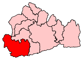
South West Surrey is a constituency represented in the House of Commons of the UK Parliament. Since 2005, the seat has been represented by Conservative MP Jeremy Hunt, the current chancellor of the Exchequer and the former Culture Secretary, Health Secretary and Foreign Secretary.

Compton is a village and civil parish in the Guildford district of Surrey, England. It is between Godalming and Guildford. It has a medieval church and a close connection to fine art and pottery, being the later life home of artist George Frederic Watts. The parish has considerable woodland and agricultural land, and the undeveloped portions are in the Metropolitan Green Belt. The village is traversed by the North Downs Way and has a large western conservation area. Central to the village are the Watts Gallery, the cemetery chapel commissioned by his wife for him, two inns and the parish church.

Godalming was an ancient hundred in the south west of the county of Surrey, England. It corresponds to the central third of the current borough of Waverley and some parts of the current borough of Guildford. Broadly speaking it extended from Guildown in the north to the border with Sussex in the south. Local people maintain the notion of the hundred, sometimes colloquially referred to as Godhelmia, mainly because of the predominance of north–south routes of communication through the area that have existed since ancient times. As recently as 1995 there were proposals to recreate a local government unit based on the old hundred borders. The name of the hundred survives in the town of Godalming.

Artington is a village and civil parish in the borough of Guildford, Surrey, England. It covers the area from the southern edge of the built-up centre of Guildford and steep Guildown, the start of the Hog's Back and part of the North Downs AONB, to New Pond Farm by Godalming and the edge of Peasmarsh. It contains Loseley Park, a country estate with dairy, and the hamlet of Littleton.

St Martha's Hill is a landmark in St Martha in Surrey, England between the town of Guildford and village of Chilworth. It is the 18th highest hill in the county and on the Greensand Ridge, in this case at the closest point to the North Downs, commencing to the immediate north at the Guildown-Merrow Down in the parishes of Guildford and Merrow. The top of the hill provides a semi-panorama of Newland's Corner also in the Surrey Hills AONB. Its church is the main amenity of the small parish extending to the south into the streets of Chilworth, with some medieval stone incorporations from a 12th-century predecessor and is a wedding venue mainly to outside the sparsely populated parish.

The Diocese of Guildford is a Church of England diocese covering eight and half of the eleven districts in Surrey, much of north-east Hampshire and a parish in Greater London. The cathedral is Guildford Cathedral and the bishop is the Bishop of Guildford. Of the two provinces of the church, it is in the Province of Canterbury.

Mother Ludlam's Cave, also known as Mother Ludlum's Cave or Mother Ludlum's Hole, is a small cave in the sandstone cliff of the Wey Valley at Moor Park, near Farnham, Surrey, in England. The cave is the subject of a number of local legends. A spring rising in the cave is recorded in the 13th century "Annals of Waverley Abbey" as "Ludewell"; other spellings through history include "Ludwell" and "Luddwelle". A monk named Symon is credited with identifying the spring as a suitable water supply for Waverley Abbey in 1218, after the original source had dried up. The brothers of the abbey dedicated the spring to St Mary, so it also became known as St Mary's Well. The cave has been naturally formed by the spring but may have been enlarged by the monks and was made into a grotto and further enhanced by addition of an ironstone arched entrance, possibly during the reign of Queen Victoria.

The River Wey is a main tributary of the River Thames in south east England. Its two branches, one of which rises near Alton in Hampshire and the other in West Sussex to the south of Haslemere, join at Tilford in Surrey. Once combined, the flow is eastwards then northwards via Godalming and Guildford to meet the Thames at Weybridge. Downstream the river forms the backdrop to Newark Priory and Brooklands. The Wey and Godalming Navigations were built in the 17th and 18th centuries, to create a navigable route from Godalming to the Thames.

St Nicolas' is an Anglican parish church in Guildford, England.

St Edmund's Church is the Roman Catholic parish church of Godalming, a town in the English county of Surrey. It was built in 1906 to the design of Frederick Walters and is a Grade II listed building. The church stands on a "dramatic hillside site" on the corner of Croft Road just off Flambard Way close to the centre of the town.
Percy Robertson RE (1868–1934) was an English watercolour landscape painter and etcher.

Godalming Museum is a local museum in the town of Godalming, Surrey, England.


