Related Research Articles

Saint Dunstan, OSB was an English bishop. He was successively Abbot of Glastonbury Abbey, Bishop of Worcester, Bishop of London and Archbishop of Canterbury, later canonised. His work restored monastic life in England and reformed the English Church. His 11th-century biographer Osbern, himself an artist and scribe, states that Dunstan was skilled in "making a picture and forming letters", as were other clergy of his age who reached senior rank. Dunstan served as an important minister of state to several English kings. He was the most popular saint in England for nearly two centuries, having gained fame for the many stories of his greatness, not least among which were those concerning his famed cunning in defeating the Devil.

Glastonbury is a town and civil parish in Somerset, England, situated at a dry point on the low-lying Somerset Levels, 23 miles (37 km) south of Bristol. The town had a population of 8,932 in the 2011 census. Glastonbury is less than 1 mile (2 km) across the River Brue from Street, which is now larger than Glastonbury.
Cheam is a suburb of London, England, 10.9 miles (17.5 km) south-west of Charing Cross. It is divided into North Cheam, Cheam Village and South Cheam. Cheam Village contains the listed buildings Lumley Chapel and the 16th-century Whitehall. It is adjacent to two large parks, Nonsuch Park and Cheam Park. Nonsuch Park contains the listed Nonsuch Mansion. Parts of Cheam Park and Cheam Village are in a conservation area. Cheam is bordered by Worcester Park to the north-west, Morden to the north-east, Sutton to the east, Epsom, Ewell and Stoneleigh to the west and Banstead and Belmont to the south.

Tavistock is an ancient stannary and market town within West Devon, England. It is situated on the River Tavy from which its name derives. At the 2011 census the three electoral wards had a population of 13,028. It traces its recorded history back to at least 961 when Tavistock Abbey, whose ruins lie in the centre of the town, was founded. Its most famous son is Sir Francis Drake.
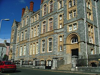
Plymouth College is a co-educational private school in Plymouth, Devon.
The Guild Church of St Dunstan-in-the-West is in Fleet Street in the City of London. It is dedicated to Dunstan, Bishop of London and Archbishop of Canterbury. The church is of medieval origin, although the present building, with an octagonal nave, was constructed in the 1830s to the designs of John Shaw.
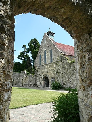
Beaulieu Abbey, grid reference SU389026, was a Cistercian abbey in Hampshire, England. It was founded in 1203–1204 by King John and populated by 30 monks sent from the abbey of Cîteaux in France, the mother house of the Cistercian order. The Medieval Latin name of the monastery was Bellus Locus Regis or monasterium Belli loci Regis. Other spellings of the English name which occur historically are Bewley and Beaulie.

Rievaulx is a small village and civil parish in Rye Dale within the North York Moors National Park near Helmsley in North Yorkshire, England and is located in what was the inner court of Rievaulx Abbey, close to the River Rye. The population of the civil parish as taken at the 2011 Census was less than 100. Details are included in the civil parish of Sproxton, North Yorkshire. The inner court of the monastery contained buildings such as the brewhouse, bakehouse and guesthouse. Its name originated as Rye + Norman-French val or valle = "valley". Its old local pronunciation was as "Rivers", and changed to "Reevo" when education brought a general familiarity with the French language.

Buckland Monachorum is a village and civil parish in the West Devon district of Devon, England, situated on the River Tavy, about 10 miles north of Plymouth.

Buckland Abbey is a Grade I listed 700-year-old house in Buckland Monachorum, near Yelverton, Devon, England, noted for its connection with Sir Richard Grenville the Younger and Sir Francis Drake. It is owned by the National Trust.
The Northampton Abbey of St James was founded in Northampton in 1104–05 by William Peverel, as a house of Augustinian canons, and was dedicated to St James. William Peverel endowed it with some forty acres in nearby Duston, the church of Duston, and the parish's mill.

St. Radegund's Abbey at Bradsole was a medieval monastic house in the parish of Hougham Without near Dover in southeast England. It was dedicated to Radegund, the sixth-century Merovingian princess, who, once married to the unsavory King Chlothar I, turned to a life of asceticism and charitable works. The remains of the abbey buildings have since have been incorporated into a farm.
Rocester Abbey was a medieval monastic house at Rocester, Staffordshire, England of which there is now no trace above ground level.

St Augustine's Abbey was a Benedictine monastery in Canterbury, Kent, England. The abbey was founded in 598 and functioned as a monastery until its dissolution in 1538 during the English Reformation. After the abbey's dissolution, it underwent dismantlement until 1848.

Sutton Harbour, formerly known as Sutton Pool, is the original port of Plymouth in Devon, England. It is still a busy fishing port and marina and is bounded on one side by the historic Barbican district. It is famous as the last departure point in England of the Mayflower, the ship that carried the Pilgrim Fathers to the New World.

Nashdom, also known as Nashdom Abbey, is a former country house and former Anglican Benedictine abbey in Burnham, Buckinghamshire, England. Designed in Neo-Georgian style by architect Edwin Lutyens, it is a Grade II* listed building. It was converted into apartments in 1997. The gardens are Grade II listed in the National Register of Historic Parks and Gardens.
Sutton High School for Boys was a grammar school in Sutton, Plymouth, Devon, England, from 1926 to 1986. It was evacuated to St Austell, Cornwall, during World War II.

References
- ↑ History Archived 2013-06-19 at the Wayback Machine , Ascot Priory, retrieved 25 April 2015
- ↑ Historic England. "St Dunstan's Abbey and Attached Road Frontage Walls (1386299)". National Heritage List for England . Retrieved 12 July 2016.
- ↑ "Plymouth's Empty Homes Partnership progress report" (PDF). Plymouth Council. Retrieved 12 July 2016.
50°22′29″N4°09′14″W / 50.3747°N 4.1538°W
| | This article about a Devon building or structure is a stub. You can help Wikipedia by expanding it. |
| | This article about a British Christian monastery, abbey, priory or other religious house is a stub. You can help Wikipedia by expanding it. |