Related Research Articles
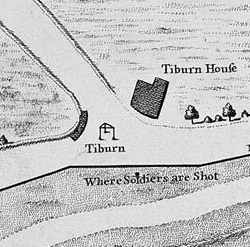
Tyburn was a manor (estate) in the county of Middlesex, England, one of two which were served by the parish of Marylebone. Tyburn took its name from the Tyburn Brook, a tributary of the River Westbourne. The name Tyburn, from Teo Bourne, means 'boundary stream'.

Charing Cross Road is a street in central London running immediately north of St Martin-in-the-Fields to St Giles Circus, which then merges into Tottenham Court Road. It leads from the north in the direction of Charing Cross at the south side of Trafalgar Square. It connects via St Martin's Place and the motorised east side of the square.

Bloomsbury is a district in the West End of London, part of the London Borough of Camden in England. It is considered a fashionable residential area, and is the location of numerous cultural, intellectual, and educational institutions. Bloomsbury is home of the British Museum, the largest museum in the United Kingdom, and several educational institutions, including University College London and a number of other colleges and institutes of the University of London as well as its central headquarters, the New College of the Humanities, the University of Law, the Royal Academy of Dramatic Art, the British Medical Association and many others. Bloomsbury is an intellectual and literary hub for London, as home of world-known Bloomsbury Publishing, publishers of the Harry Potter series, and namesake of the Bloomsbury Group, a group of British intellectuals which included author Virginia Woolf, biographer Lytton Strachey, and economist John Maynard Keynes.

Holborn, an area in central London, covers the south-eastern part of the London Borough of Camden and a part of the Ward of Farringdon Without in the City of London.
Drury Lane is a street on the eastern boundary of the Covent Garden area of London, running between Aldwych and High Holborn. The northern part is in the borough of Camden and the southern part in the City of Westminster. Drury Lane is part of London's West End Theatreland.

Tottenham Court Road is a major road in Central London, almost entirely within the London Borough of Camden.

St Giles Circus is a road junction in the St Giles district of the West End of London at the eastern end of Oxford Street, where it connects with New Oxford Street, Charing Cross Road and Tottenham Court Road, which it is more often referred to owing to the location of Tottenham Court Road Underground station directly under the junction. It is near to Soho, Covent Garden, Bloomsbury and Fitzrovia.

Moorfields was an open space, partly in the City of London, lying adjacent to – and outside – its northern wall, near the eponymous Moorgate. It was known for its marshy conditions, the result of the defensive wall acting as a dam, impeding the flow of the River Walbrook and its tributaries.
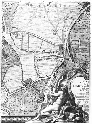
St George's Fields was an area of Southwark in south London, England.

St Giles-without-Cripplegate is an Anglican church in the City of London, located on Fore Street within the modern Barbican complex. When built it stood without the city wall, near the Cripplegate. The church is dedicated to St Giles, patron saint of handicapped and infirm people of many different kinds. It is one of the few medieval churches left in the City of London, having survived the Great Fire of 1666.

Newington Causeway is a road in Southwark, London, between the Elephant and Castle and Borough High Street. Elephant & Castle Underground station is at the southern end. It follows the route of the old Roman road Stane Street.

The City and Liberty of Westminster was a unit of local government in the county of Middlesex, England. It was located immediately to the west of the City of London. Originally under the control of Westminster Abbey, the local authority for the area was the Westminster Court of Burgesses from 1585 to 1900. The area now forms the southern part of the City of Westminster in Greater London.

Woodstock Road is a major road in Oxford, England, running from St Giles' in the south, north towards Woodstock through the leafy suburb of North Oxford. To the east is Banbury Road, which it meets at the junction with St Giles'.
St Giles' is a wide boulevard leading north from the centre of Oxford, England. At its northern end, the road divides into Woodstock Road to the left and Banbury Road to the right, both major roads through North Oxford. At the southern end, the road continues as Magdalen Street at the junction with Beaumont Street to the west. Also to the west halfway along the street is Pusey Street. Like the rest of North Oxford, much of St Giles' is owned by St John's College.

St Giles' Church is a church in North Oxford, England. It is at the northern end of the wide thoroughfare of St Giles', at the point where it meets Woodstock Road and Banbury Road. It stands between where Little Clarendon Street joins Woodstock Road and Keble Road joins Banbury Road.
Holy Trinity Church, in Marylebone, Westminster, London, is a Grade I listed former Anglican church, built in 1828 and designed by John Soane. In 1818 Parliament passed an act setting aside one million pounds to celebrate the defeat of Napoleon. This is one of the so-called "Waterloo churches" that were built with the money. The building has an entrance off-set with four large Ionic columns. There is a lantern steeple, similar to St Pancras New Church, which is also on Euston Road to the east.

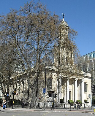
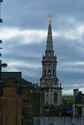
St Giles in the Fields is the Anglican parish church of the St Giles district of London. The parish stands within the London Borough of Camden and forms part of the Diocese of London. The church, named for St Giles the Hermit, began as the chapel of a 12th-century monastery and leper hospital in the fields between Westminster and the City of London and now gives its name to the surrounding urban district of St Giles in the West End of London, situated between Seven Dials, Bloomsbury, Holborn and Soho. The present church is the third on the site since 1101 and was rebuilt most recently in 1731–1733 in Palladian style to designs by the architect Henry Flitcroft.
St Giles is an area in London, England and is located in the London Borough of Camden. It is in Central London and part of the West End. It gets its name from the parish church of St Giles in the Fields. The combined parishes of St Giles in the Fields and St George Bloomsbury were administered jointly for many centuries; leading to the conflation of the two, with much or all of St Giles usually taken to be a part of Bloomsbury. Points of interest include the church of St Giles in the Fields, Seven Dials, the Phoenix Garden, and St Giles Circus.

Wellclose Square is a public square in the London Borough of Tower Hamlets, between Cable Street to the north and The Highway to the south.

The Camberwell Collegiate School was a private school in Camberwell, London, England. It was located on the eastern side of Camberwell Grove, directly opposite the Grove Chapel.
References
- ↑ Knight, Charles (3 March 2018). "London". Charles Knight & Company – via Google Books.
- ↑ A Handbook for London, Past and Present, Peter Cunningham, (1849)
- ↑ Dobie, Rowland (3 March 2018). "The history of the united parishes of St. Giles in the Fields and St. George Bloomsbury, combining strictures on their parochial government, and a variety of information of local and general interest". London, Printed for the author [by F. Marshall] – via Internet Archive.