
The Pembrokeshire Coast Path, often called the Pembrokeshire Coastal Path, is a designated National Trail in Pembrokeshire, southwest Wales. Established in 1970, it is a 186-mile (299 km) long-distance walking route, mostly at cliff-top level, with a total of 35,000 feet (11,000 m) of ascent and descent. At its highest point – Pen yr afr, on Cemaes Head – it reaches a height of 574 feet (175 m), and at its lowest point – Sandy Haven crossing, near Milford Haven – it is just 6 feet (2 m) above low water. Whilst most of the coastline faces west, it offers – at varying points – coastal views in every direction of the compass.

Pembroke is a town and community in Pembrokeshire, Wales, with a population of 7,552. The names of both the town and the county have a common origin; both are derived from the Cantref of Penfro: Pen, 'head' or 'end', and bro, 'region', 'country', 'land', which has been interpreted to mean either 'Land's End' or 'headland'.

Pembrokeshire Coast National Park is a national park along the Pembrokeshire coast in west Wales.

Dinas Cross is a village, a community and a former parish in Pembrokeshire, Wales. Located between Fishguard and Newport in the Pembrokeshire Coast National Park, it is a popular holiday destination on the A487 road. The two hamlets, Cwm-yr-Eglwys and Pwllgwaelod, are in the community. The community has an elected community council and until 2022 gave its name to an electoral ward of Pembrokeshire County Council which covered the communities of Dinas Cross, Cwm Gwaun and Puncheston.

The Stackpole Estate is located between the villages of Stackpole and Bosherston in Pembrokeshire, Wales, within the Pembrokeshire Coast National Park. It is situated within the community of Stackpole and Castlemartin.

Carboniferous Limestone is a collective term for the succession of limestones occurring widely throughout Great Britain and Ireland that were deposited during the Dinantian Epoch of the Carboniferous Period. These rocks formed between 363 and 325 million years ago. Within England and Wales, the entire limestone succession, which includes subordinate mudstones and some thin sandstones, is known as the Carboniferous Limestone Supergroup.
Barafundle Bay is a remote, slightly curved, east-facing sandy beach, near Stackpole Quay in Pembrokeshire, Wales, in Stackpole and Castlemartin Community. It is part of the Stackpole Estate, managed by The National Trust. The beach was once owned by the Cawdor family of Stackpole Court. On the northern approach to the beach are steps and a wall, which were built by the owners to ease their access to what was then their private beach.

Bosherston is a village and parish in Pembrokeshire, Wales, within the Pembrokeshire Coast National Park.
Castlemartin is a village and parish in the community of Stackpole and Castlemartin, Pembrokeshire, Wales, in the Pembrokeshire Coast National Park.
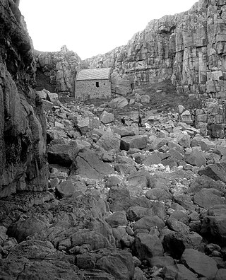
Saint Govan was a hermit who lived in a fissure on the side of coastal cliff near Bosherston, in the Pembrokeshire Coast National Park, Wales. St. Govan's Chapel was built in the fissure in the 13th century on what is now known as St. Govan's Head.
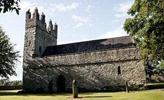
St. Mary's Church, Castlemartin, located in the broad Kilcullen area of County Kildare, Ireland, is the first medieval church in Ireland to have been restored to full working order. The small stone Roman Catholic church, with accompanying burial ground, lies within Castlemartin Estate, which belonged for many years to media magnate Tony O'Reilly; O'Reilly paid for the restoration in 1979–1980, after which the church was reconsecrated in August 1981 by Archbishop Dermot Ryan. There has been a church on this site for over 800 years.

Warren is an ancient parish in the community of Stackpole and Castlemartin, in the most southerly part of Pembrokeshire, Wales. Its northern edge is 5 miles (8 km) south of Pembroke and its southern edge reaches the sea at Flimston Bay. It is bordered by Castlemartin to the west, St Twynnells to the east and Monkton to the north.

Castlemartin Training Area is a British Army military training area and armoured fighting vehicle range located in the Welsh county of Pembrokeshire. It was originally established for tank training by the Royal Armoured Corps in 1938. The training area is located within the Pembrokeshire Coast National Park, on the South Pembrokeshire coast.

This is a list of Grade I-listed buildings in the county of Pembrokeshire, Wales.
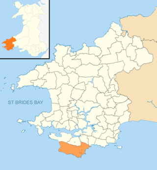
Stackpole and Castlemartin is a community in Pembrokeshire, Wales, 4 miles (6.4 km) south of Pembroke.

The Green Bridge of Wales is a natural arch formed from Carboniferous Limestone within the Pembrokeshire Coast National Park, Pembrokeshire, Wales. It is located in the Castlemartin military training area just beyond the car park at Stack Rocks and beside the Pembrokeshire Coast Path.

Huntsman's Leap is a deep, narrow and sheer-sided coastal chasm or geo developed in the Carboniferous Limestone of the Pembrokeshire Coast National Park, Pembrokeshire, Wales. Like the nearby Green Bridge of Wales and St Govan's Chapel, it is a popular visitor attraction which lies beside the Pembrokeshire Coast Path. The site lies within the eastern sector of the Ministry of Defence's Castlemartin military training area, but access for the public is normally available.
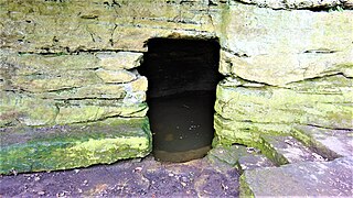
The early 13th century St Robert's Cave and Chapel of the Holy Cross, also known with variants such as St Robert's Chapel and Chapel of the Holy Rood, are located on Abbey Road beside the River Nidd in its gorge at Knaresborough. The cave is a rare example of a medieval hermitage, cut out of the magnesian limestone river gorge with a domestic area externally and the chapel of the Holy Cross which originally housed the saint's grave.

The Church of St Michael and All Angels, Castlemartin, Pembrokeshire, Wales is a redundant church dating from the 13th century. A Grade I listed building, the church is now in the care of the Friends of Friendless Churches.


