
Niue is a self-governing island country in free association with New Zealand. It is situated in the South Pacific Ocean and is part of Polynesia, and predominantly inhabited by Polynesians. The island is commonly referred to as "The Rock", which comes from the traditional name "Rock of Polynesia".

A trail, also known as a path or track, is an unpaved lane or a small paved road not intended for usage by motorized vehicles, usually passing through a natural area. In the United Kingdom and Ireland, a path or footpath is the preferred term for a pedestrian or hiking trail. The term is also applied in North America to accompanying routes along rivers, and sometimes to highways. In the US, the term was historically used for a route into or through wild territory used by explorers and migrants. In the United States, "trace" is a synonym for trail, as in Natchez Trace.

The National Park Service (NPS) is an agency of the United States federal government, within the U.S. Department of the Interior. The service manages all national parks; most national monuments; and other natural, historical, and recreational properties, with various title designations. The United States Congress created the agency on August 25, 1916, through the National Park Service Organic Act. Its headquarters are in Washington, D.C., within the main headquarters of the Department of the Interior.

Hanmer Springs is a small town in the Canterbury region of the South Island of New Zealand. The Māori name for Hanmer Springs is Te Whakatakanga o te Ngārahu o te ahi a Tamatea, which means “where the ashes of Tamate’s (sic) fire lay”, referring to Tamatea, the captain of the canoe Tākitimu.

Mount Aspiring National Park is in the Southern Alps of the South Island of New Zealand, north of Fiordland National Park, situated in Otago and Westland regions. The park forms part of the Te Wahipounamu World Heritage Site.

Molesworth Station is a high country cattle station. It is located behind the Inland Kaikōura Mountain range in the South Island's Marlborough District. It is New Zealand's largest farm, at over 1,800 square kilometres and supports the country's biggest herd of cattle. It also hosts government science programs, such as research into bovine tuberculosis and related research into possums. The station helps rabbit population reduction.
This is a timeline of environmental history of New Zealand. It includes notable events affecting the natural environment of New Zealand as a result of human activity.
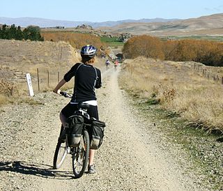
The Otago Central Rail Trail is a 150-kilometre walking, cycling and horse riding track in the South Island of New Zealand. A pioneering project for New Zealand, the successful rail trail joined the New Zealand Cycle Trail umbrella organisation in 2012, having been one of the inspirations for it.

A rail trail is a shared-use path on railway right of way. Rail trails are typically constructed after a railway has been abandoned and the track has been removed but may also share the right of way with active railways, light rail, or streetcars, or with disused track. As shared-use paths, rail trails are primarily for non-motorized traffic including pedestrians, bicycles, horseback riders, skaters, and cross-country skiers, although snowmobiles and ATVs may be allowed. The characteristics of abandoned railways—gentle grades, well-engineered rights of way and structures, and passage through historical areas—lend themselves to rail trails and account for their popularity. Many rail trails are long-distance trails, while some shorter rail trails are known as greenways or linear parks.
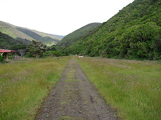
The Remutaka Rail Trail is a walking and cycling track in the North Island of New Zealand. It runs between Maymorn and Cross Creek, and follows 22 kilometres (14 mi) of the original route of the Wairarapa Line over the Remutaka Range between the Mangaroa Valley and the Wairarapa, including the world-famous Rimutaka Incline. Parts of the trail are also used by vehicles both from the regional council and from forestry companies with tree plantations in the area; members of the public have limited vehicular access from the Kaitoke end to a car park, go-kart track and gun range. Access is also granted by permission to horse riders. Touring coaches have been used upon occasion to convey tourists and other visitors to various parts of the route.

The Florida Department of Environmental Protection (FDEP) is the Florida government agency responsible for environmental protection.

The environment of New Zealand is characterised by an endemic flora and fauna which has evolved in near isolation from the rest of the world. The main islands of New Zealand span two biomes, temperate and subtropical, complicated by large mountainous areas above the tree line. There are also numerous smaller islands which extend into the subantarctic. The prevailing weather systems bring significantly more rain to the west of the country. New Zealand's territorial waters cover a much larger area than its landmass and extend over the continental shelf and abyssal plateau in the South Pacific Ocean, Tasman Sea and Southern ocean.

A station or run, in the context of New Zealand agriculture, is a large farm dedicated to the grazing of sheep and cattle. The use of the word for the farm or farm buildings date back to the mid-nineteenth century. The owner of a station is called a runholder.

Cycling in New Zealand is the 5th most popular form of active recreation, but a very marginal commuting mode, with the share hovering around 1–3% in most major cities. This is due to a number of factors, principally safety fears.

The New Zealand Cycle Trail project is a New Zealand government initiative, co-funded together with local councils and charitable trusts, which is to build and operate a network of cycle routes through the country.
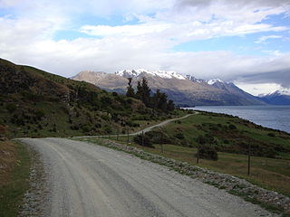
The Around the Mountains Cycle Trail is a cycle trail set in the remote wilderness of southern New Zealand. 186 km in length, it can be ridden in either direction, starting at Kingston or Walter Peak and taking three to five days at a relaxed pace to complete. The Around the Mountains Cycle Trail is recognised as one of New Zealand's 23 Great Rides.

Lake Tennyson is a glacial high-country lake in Canterbury, New Zealand. The first European settler to see the lake was Frederick Weld in 1853, who also named it. The headwaters of the Waiau Toa / Clarence River are just to the north, and the river flows through Lake Tennyson.

The Old Ghost Road is a mountain bike and tramping trail part-funded as one of the projects of the New Zealand Cycle Trail (NZCT) system in the Buller District of New Zealand. Of all NZCT projects, it is the technically most difficult one to ride and is rated "advanced". The highest point of the trail is at 1,280 metres (4,200 ft).

The Wairarapa Moana Wetlands are a major wetland, located in the South Wairarapa District in the Wellington Region at the southern end of New Zealand's North Island.

