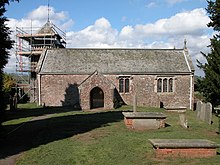
St Maughans (Welsh : Llanfocha) is a village in Monmouthshire, south east Wales, United Kingdom.

St Maughans (Welsh : Llanfocha) is a village in Monmouthshire, south east Wales, United Kingdom.
St Maughans is located three miles north west of Monmouth.
In around 860, Britcon and Iliuc gave Lann Mocha (St Maughans) to Archbishop Dyfrig with the consent of King Meurig ab Arthfael. [1]
St Maughans is close to the River Monnow and the border with England. The parish contains the Hilston Park.
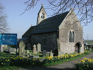
The village has a church dedicated to Saint Maughan, which dates from the 12th or 13th century and has a distinctive local dovecote belfry. The church was much restored by the architect J. P. Seddon in 1865/6. [2]
The village has given its name to the St Maughans Formation, the lowest Devonian rocks of the Old Red Sandstone.

Llanvapley is a village in the community of Gobion Fawr, in Monmouthshire, south east Wales, United Kingdom. Llan has replaced the (earlier) Eglwys (1254). This village lies 4 miles north east of 2023’s Best Places to Live listed town, Abergavenny.

Llanfoist is a village near Abergavenny, in Monmouthshire, Wales, in the community of Llanfoist Fawr. Llanfoist derives from Ffwyst, an early Christian Welsh saint, although the anglicised version of the church patron is Saint Faith. The population was 1,228 in 2011.

St Brides Netherwent is a parish and largely deserted village in Monmouthshire, south-east Wales. It is centred 2 miles north of Magor, and 3 miles west of Caerwent. The A48 Newport to Chepstow road passes close by to the north.

Undy is a village in Monmouthshire, south east Wales, adjoining the village of Magor with which it forms the community and parish of Magor with Undy. It is located about 3 miles (4.8 km) west of Caldicot and 10 miles (16 km) east of Newport, close to the junction of the M4 and M48 motorways, and adjoins the Caldicot Levels on the north bank of the Bristol Channel.

Wilcrick is a hamlet within the administrative boundary of the city of Newport, South Wales, just to the west of Magor and approximately 7 miles (11 km) southeast of Newport city centre. It is within the historic county of Monmouthshire.

Kemeys Commander is a village in Monmouthshire, in South East Wales.

St Brides Wentloog is a hamlet to the south west of the city of Newport in South Wales.

Tregare is an ancient parish on the northern border of the Raglan hundred of Monmouthshire in southeast Wales.

Ewyas Harold is a village and civil parish in the Golden Valley in Herefordshire, England, near the Wales-England border about halfway between Abergavenny, Monmouthshire, and Hereford. The population of this civil parish at the 2011 census was 883. It lies on the Dulas brook, and is contiguous with the neighbouring village of Pontrilas.

Wolvesnewton is a small village in Monmouthshire, Wales.

Llanover is a village in the community of Goetre Fawr in Monmouthshire, Wales.

Llandegveth, also known by its Welsh name Llandegfedd, is a village in Monmouthshire, south east Wales. It is located between Cwmbran, in Torfaen, and Usk in rural Monmouthshire.
Mamhilad is a village in the community of Goetre Fawr in Monmouthshire, south east Wales.

Oldcastle is a small village in Monmouthshire, south east Wales.

Llantrisant is a village in Monmouthshire, south east Wales, United Kingdom. The community population at the 2011 census was 475.

Llangua is a small village in Grosmont community, Monmouthshire, south-east Wales, United Kingdom. Saint Ciwa is said to have built a church there in the 7th century.

Gwernesney is a village in Monmouthshire in southeast Wales.

Partrishow, also known as Patricio, Patrishow, or by its Welsh names Merthyr Isw and Llanisw, is a small village and historic parish in the county of Powys, close to its border with Monmouthshire. It is in the valley of the Grwyne Fawr, in the Black Mountains of South Wales, within the Brecon Beacons National Park.

Pandy is a hamlet in Monmouthshire, south east Wales, United Kingdom.

Trellech United is a community and electoral ward in the county of Monmouthshire, Wales. It lies south of the county town of Monmouth next to the Wales-England border.
51°51′00″N2°47′02″W / 51.84988°N 2.78391°W