
Sherborne Abbey, otherwise the Abbey Church of St. Mary the Virgin, is a Church of England church in Sherborne in the English county of Dorset. It has been a Saxon cathedral (705–1075), a Benedictine abbey church (998–1539), and since 1539, a parish church.

The Isle of Purbeck is a peninsula in Dorset, England. It is bordered by water on three sides: the English Channel to the south and east, where steep cliffs fall to the sea; and by the marshy lands of the River Frome and Poole Harbour to the north. Its western boundary is less well defined, with some medieval sources placing it at Flower's Barrow above Worbarrow Bay. John Hutchins, author of The History and Antiquities of the County of Dorset, defined Purbeck's western boundary as the Luckford Lake steam, which runs south from the Frome. According to writer and broadcaster Ralph Wightman, Purbeck "is only an island if you accept the barren heaths between Arish Mell and Wareham as cutting off this corner of Dorset as effectively as the sea." The most southerly point is St Alban's Head.

Purbeck was a local government district in Dorset, England. The district was named after the Isle of Purbeck, a peninsula that forms a large proportion of the district's area. However, it extended significantly further north and west than the traditional boundary of the Isle of Purbeck which is the River Frome. The district council was based in the town of Wareham, which is itself north of the Frome.

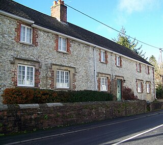
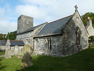
Worth Matravers is a village and civil parish in the English county of Dorset. The village is situated on the cliffs west of Swanage. It comprises limestone cottages and farm houses and is built around a pond, which is a regular feature on postcards of the Isle of Purbeck.

Lydlinch is a village and civil parish in the Blackmore Vale in north Dorset, England, about three miles west of Sturminster Newton. The village is sited on Oxford clay close to the small River Lydden. The parish – which includes the village of King's Stag to the south and the hamlet of Stock Gaylard to the west – is bounded by the Lydden to the east and its tributary, the Caundle Brook, to the north.
Bishopstrow is a small village and civil parish in Wiltshire, England, on the southeastern edge of the town of Warminster. The village is about 1.5 miles (2.4 km) from the town centre, south of the old Warminster to Salisbury road, formerly the A36, now the B3414.

Sedgehill is a small village and former civil parish, now in the parish of Sedgehill and Semley, in the southwest of the county of Wiltshire, England. It lies to the west of the A350 primary route, about 3+1⁄4 miles (5 km) north of Shaftesbury, Dorset.

Oddington is a village and civil parish about 5 miles (8 km) south of Bicester in Oxfordshire, England. The village is close to the River Ray on the northern edge of Otmoor. The 2011 Census recorded the parish's population as 129.

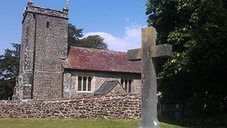
St Aldhelm's Chapel is a Norman chapel on St Aldhelm's Head in the parish of Worth Matravers, Swanage, Dorset. It stands close to the cliffs, 108 metres (354 ft) above sea level. It is a Grade I listed building.

Shrewton is a village and civil parish on Salisbury Plain in Wiltshire, England, around 6 miles (9.7 km) west of Amesbury and 14 miles (23 km) north of Salisbury. It lies on the A360 road between Stonehenge and Tilshead. It is close to the source of the River Till, which flows south to Stapleford.

Semley is a village and former civil parish, now in the parish of Sedgehill and Semley, in Wiltshire, England, about 3 miles (4.8 km) north-east of Shaftesbury in neighbouring Dorset. The hamlet of Sem Hill lies about a quarter of a mile west of the village. In 1961 the parish had a population of 477.
St Mary the Virgin is the Church of England parish church of Lytchett Matravers in Dorset. Its parish is part of the Diocese of Salisbury. The building is Grade I listed.
Cranborne Priory is a former priory church in the village of Cranborne, Dorset, England. Founded in 980 as Cranborne Abbey, it became a priory in 1102, remaining that way until it was dissolved in 1540. The tower, nave and aisles from the priory survive to form the Church of St Mary and St Bartholomew, the parish church of Cranborne. The building, which has fragments from the 12th century, is designated a Grade I listed building.

St Nicholas's Church in Fisherton Delamere, Wiltshire, England, was built in the 14th century. It is recorded in the National Heritage List for England as a designated Grade II* listed building, and is now a redundant church in the care of the Churches Conservation Trust. It was declared redundant on 1 June 1982, and was vested in the Trust on 30 October 1984.
St Mary's Church is on Church Street, Cleobury Mortimer, Shropshire, England. It is an active Anglican parish church in the deanery of Ludlow, the archdeaconry of Ludlow, and the diocese of Hereford. Its benefice is united with those of six local parishes to form the Cleobury Benefice. The church is recorded in the National Heritage List for England as a designated Grade I listed building. It is notable for its shingled twisted spire.

St Aldhelm's Church is a Grade II* listed Anglican church in the village of Belchalwell, Dorset. It is in the ecclesiastical parish of Belchalwell, which is part of the Benefice of Hazelbury Bryan and the Hillside Parishes.

St Nicholas of Myra is a Grade I listed parish church in South Ockendon, Essex, England, 20 miles east of London and 8 miles south-east of Romford. The building has been under the National Heritage List for England since February 8, 1960. It stands on the south side of the green in the middle of the village as it has done for 860 years.
Holy Trinity Church is a Church of England parish church in Bincombe, Dorset, England. The church has late 12th-century origins, with later additions and a restoration of 1865. It is a Grade I listed building.

St Mary's Church is a parish church in Swanage, Dorset. It is dedicated to the Virgin Mary. The church is in the Archdeaconry of Dorset, in the Diocese of Salisbury. The tower is mediaeval; the church itself is a 19th and early 20th-century reconstruction. It is Grade II listed.

The Priest's Way is the historical route taken by clergy from St Nicholas's, Worth Matravers to St Mary's Church, Swanage in the Isle of Purbeck in Dorset. The track arose as a result of St Mary's being a chapel of ease to St Nicholas's, and followed the route priests took to say mass in Swanage. A modern footpath and bridleway follows much of the route.


