
Kentish Town is an area of northwest London, England in the London Borough of Camden, immediately north of Camden Town. Less than four miles north of central London, Kentish Town has good transport connections and is situated close to the open spaces of Hampstead Heath.
St Pancras is a district in central London. It was originally a medieval ancient parish and subsequently became a metropolitan borough. The metropolitan borough then merged with neighbouring boroughs and the area it covered now forms around half of the modern London Borough of Camden. The area of the parish and borough includes the sub-districts of Camden Town, Kentish Town, Gospel Oak, Somers Town, King's Cross, Chalk Farm, Dartmouth Park, the core area of Fitzrovia and a part of Highgate.

King's Cross is a district on either side of Euston Road, in north London, England, 1.5 miles (2.4 km) north of Charing Cross. It is bordered by Barnsbury to the north, Clerkenwell and Islington to the east, Holborn to the south and Euston to the west. It is served by two major rail termini, St Pancras and King's Cross. King's Cross station is the terminus of one of the major rail routes between London and the North.

Camden Town, often shortened to Camden, is an area in the London Borough of Camden, around 2.5 miles (4.1 km) north-northwest of Charing Cross. Historically in Middlesex, it is identified in the London Plan as one of 34 major centres in Greater London.
The River Fleet is the largest of London's subterranean rivers, all of which today contain foul water for treatment. It has been used as a sewer since the development of Joseph Bazalgette's London sewer system in the mid-19th century with the water being treated at Beckton Sewage Treatment Works. Its headwaters are two streams on Hampstead Heath, each of which was dammed into a series of ponds—the Hampstead Ponds and the Highgate Ponds—in the 18th century. At the southern edge of Hampstead Heath these descend underground as sewers and join in Camden Town. The waters flow 4 miles (6 km) from the ponds.

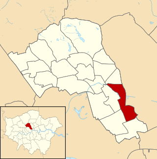
St Pancras was a civil parish and metropolitan borough in London, England. It was an ancient parish in the county of Middlesex, governed by an administrative vestry. The parish was included in the area of responsibility of the Metropolitan Board of Works in 1855 and became part of the County of London in 1889. The parish of St Pancras became a metropolitan borough in 1900, following the London Government Act 1899, with the parish vestry replaced by a borough council. In 1965 the borough was abolished and its former area became part of the London Borough of Camden in Greater London.

Holborn and St Pancras is a parliamentary constituency in Greater London that was created in 1983. It has been represented in the House of Commons of the Parliament of the United Kingdom since 2015 by Sir Keir Starmer, the current Leader of the Labour Party and Leader of the Opposition.

St Pancras Old Church is a Church of England parish church on Pancras Road, Somers Town, in the London Borough of Camden. Somers Town is an area of the ancient parish and later Metropolitan Borough of St Pancras.

Agar Town was a small, historically poor neighbourhood of St Pancras in central London. Most of the area was demolished making way for St Pancras railway station.
King's Cross Central (KXC) is a mixed-use development in the north-east of central London. The site is owned and controlled by the King's Cross Central Limited Partnership. It consists of approximately 67 acres (27 ha) of former railway lands to the north of King's Cross and St Pancras mainline railway stations. The site is largely determined by three boundaries: the existing East Coast Main Line railway leading out of King's Cross; York Way, a road marking the division between Camden and Islington boroughs; and the new railway line, High Speed 1 (HS1), formerly known as the Channel Tunnel Rail Link, which curves around the site to the north and west.
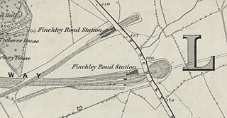
Finchley Road railway station was built by the Midland Railway (MR) in 1868 on its extension to St. Pancras. Situated at the north end of the Belsize Tunnels, it served the newly developed area of St John's Wood.

St Mary's Church is a Church of England church on Eversholt Street in Somers Town, in the London Borough of Camden.

The Highgate Road railway stations were two adjacent but separate stations of the Tottenham & Hampstead Junction Railway in the north of Kentish Town, in St Pancras, London, now the London Borough of Camden. They were located on separate and parallel lines that joined east of the stations. The lines through both stations remain open.
King's Cross is a ward of the London borough of Camden, in the United Kingdom. The ward has existed since the creation of the borough on 1 April 1965 and was first used in the 1964 elections. The population of the ward at the 2011 Census was 11,843. In 2018, the ward had an electorate of 7,274. The Boundary Commission projects the electorate to rise to 8,459 in 2025.

The London Borough of Camden is a London borough in Inner London, England. Camden Town Hall, on Euston Road, lies 1.4 mi (2.3 km) north of Charing Cross. The borough was established on 1 April 1965 and includes the former Central London borough of Holborn, and St Pancras and Hampstead.

Pancras Square Library is in the London Borough of Camden located just off the Euston Road in the King's Cross area of the borough. It is situated on the ground floor of Camden Council's Town Hall complex. With a separate children's library it provides a wide selection of books, CDs and DVDs available to borrow, and free internet access, making it central to provide a library service and gateway to other Council services to the local community.
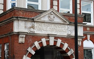
The St Pancras Female Orphanage is a former health facility in Somers Town, London.

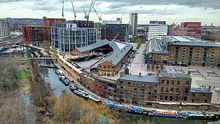
Camley Street is a street in the London Borough of Camden in London, England. It lies in St Pancras and King's Cross: stretching over a kilometre from St Pancras railway station in the south, over the Regent's Canal, and to Agar Grove in the north.

Chalton Street is a street in the Somers Town neighbourhood of London, England. Chalton Street is over a kilometre long and stretches from Euston Road to almost Camden Town, before taking a hard right turn and terminating at St Pancras Hospital.

The Constitution is a long-established public house on St Pancras Way in Camden Town, London, owned by Young's Brewery. Opened in 1858 in what was then Agar Town, it overlooks Regent's Canal.
