
Marylebone Road is an important thoroughfare in central London, within the City of Westminster. It runs east-west from the Euston Road at Regent's Park to the A40 Westway at Paddington. The road which runs in 3 lanes in both directions, is part of the London Inner Ring Road and as such forms part of the boundary of the zone within which the London congestion charge applies.

The Metropolitan Borough of Westminster was a metropolitan borough in the County of London, England, from 1900 to 1965.

The Metropolitan Borough of St Marylebone was a metropolitan borough of the County of London from 1900 to 1965. It was based directly on the previously existing civil parish of St Marylebone, which was incorporated into the Metropolitan Board of Works area in 1855, retaining a parish vestry, and then became part of the County of London in 1889.

Great Portland Street in the West End of London links Oxford Street with Albany Street and the A501 Marylebone Road and Euston Road. A commercial street including some embassies, it divides Fitzrovia, to the east, from Marylebone to the west. It delineates areas with contrasting identities, the west at strongest in grandiose Portland Place and Harley Street, the east at strongest in artists' and independent businesses of Fitzrovia. The street has its own unique character, due in part of the unusual combination of small shops combined with its strongly rectilinear character.

Holy Trinity Church, in Marylebone, Westminster, London, is a Grade I listed former Anglican church, built in 1828 and designed by John Soane. In 1818 Parliament passed an act setting aside one million pounds to celebrate the defeat of Napoleon. This is one of the so-called "Waterloo churches" that were built with the money. It has an external pulpit facing onto Marylebone Road, and an entrance with four large Ionic columns. There is a lantern steeple, similar to St Pancras New Church, which is also on Euston Road to the east.
There are several long-established Nordic churches in London. All seek to provide Lutheran Christian worship and pastoral care to their respective national communities in their own languages. Many of the churches also organise language classes and organise a wide range of social activities.

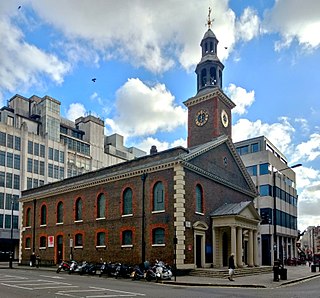
St Marylebone Parish Church is an Anglican church on the Marylebone Road in London. It was built to the designs of Thomas Hardwick in 1813–17. The present site is the third used by the parish for its church. The first was further south, near Oxford Street. The church there was demolished in 1400 and a new one erected further north. This was completely rebuilt in 1740–42, and converted into a chapel-of-ease when Hardwick's church was constructed. The Marylebone area takes its name from the church. Located behind the church is St Marylebone School, a Church of England school for girls.
St Peter, Vere Street, known until 1832 as the Oxford Chapel after its founder Edward Harley, 2nd Earl of Oxford and Earl Mortimer, is a former Anglican church off Oxford Street, London. It has sometimes been referred to as the Marybone Chapel or Marylebone Chapel.

Great Titchfield Street is a street in the West End of London. It runs north from Oxford Street to Greenwell Street, just short of the busy A501 Marylebone Road and Euston Road. It lies within the informally designated London area of Fitzrovia. In administrative terms it is in the City of Westminster. It lies within their designated East Marylebone Conservation Area in the former Metropolitan Borough of St Marylebone.
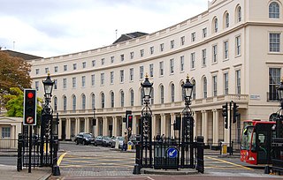
Park Crescent is at the north end of Portland Place and south of Marylebone Road in London. The crescent consists of elegant stuccoed terraced houses by the architect John Nash, which form a semicircle. The crescent is part of Nash's and wider town-planning visions of Roman-inspired imperial West End approaches to Regent's Park. It was originally conceived as a circus (circle) to be named Regent's Circus but instead Park Square was built to the north. The only buildings on the Regent's Park side of the square are small garden buildings, enabling higher floors of the Park Crescent buildings to have a longer, green northern view.

Langham Place is a short street in Westminster, central London, England. It connects Portland Place to the north with Regent Street to the south in London's West End. It is, or was, the location of many significant public buildings.

Marylebone is an area in the West End of London, in the City of Westminster. Oxford Street, Europe's busiest shopping street, forms its southern boundary.
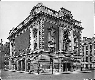
The Philharmonic Hall, 97 Great Portland Street, London, originally the St James's Hall, was built in 1907–08 to replace the St James's Hall that once stood in Regent Street. The building was then used by the BBC and known as Brock House. It is now leased to The Office Group.

Hinde Street Methodist Church in Hinde Street, Marylebone, London, is Grade II listed with Historic England. It was built 1807-10 and rebuilt in the 1880s.
Weymouth Street lies in the Marylebone district of the City of Westminster and connects Marylebone High Street with Great Portland Street. The area was developed in the late 18th century by Henrietta Cavendish Holles and her husband Edward Harley, 2nd Earl of Oxford. This part of Marylebone originally belonged to the Manor of Tyburn which existed at the time of the Domesday Book (1086).

New Cavendish Street is a street in the City of Westminster, London, that runs from Marylebone High Street in the west to Cleveland Street in the east.

Henrietta Place, originally known as Henrietta Street, is a street in Marylebone in the City of Westminster in central London that runs from Marylebone Lane in the east to Cavendish Square in the west. It is joined on the north side by Welbeck Street and Wimpole Street, and on the south side by Vere Street, Chapel Place, and Old Cavendish Street.
Harcourt House was a palatial residence built in about 1722 by Thomas Archer on Cavendish Square. The main structure was largely demolished in 1906 leaving only the southern wing on the corner with Margaret Street, now Flanders House. The southern wing of the building survives today as 1A Cavendish Square.

Wells Street is a street in the City of Westminster. It runs from Riding House Street in the north to Oxford Street in the south. It is crossed by Mortimer Street and Eastcastle Street. It is joined on its western side by Marylebone Passage and on the eastern side by Booth's Place and Wells Mews.
The London Organ School and College of Music was a music school established in 1865 by Frederick Scotson Clark. It later merged with other schools to become the London Academy of Music and Dramatic Art.

