Bristol Temple Meads is the oldest and largest railway station in Bristol, England. It is located 118 miles 31 chains away from London Paddington. It is an important transport hub for public transport in the city; there are bus services to many parts of the city and surrounding districts, with a ferry to the city centre. Bristol's other major station, Bristol Parkway, is a more recent station on the northern outskirts of the conurbation. It is the busiest station in South West England.

The Hungerford Bridge crosses the River Thames in London, and lies between Waterloo Bridge and Westminster Bridge. Owned by Network Rail Infrastructure Ltd it is a steel truss railway bridge flanked by two more recent, cable-stayed, pedestrian bridges that share the railway bridge's foundation piers, and which are named the Golden Jubilee Bridges.

The Hope Valley line is a trans-Pennine railway line in Northern England, linking Manchester with Sheffield. It was completed in 1894.

Downham Market railway station is on the Fen line in the east of England, serving the town of Downham Market, Norfolk. It is 86 miles 8 chains (138.6 km) measured from London Liverpool Street and is situated between Littleport and Watlington stations. Its three-letter station code is DOW.

Newport is the second-busiest railway station in Wales. It is situated in Newport city centre and is 133 miles 13 chains (214.3 km) from London Paddington measured via Bristol Parkway, and 158 miles 50 chains (255.3 km) via Stroud.
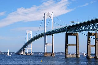
The Claiborne Pell Bridge, commonly known as the Newport Bridge, is a suspension bridge operated by the Rhode Island Turnpike and Bridge Authority that spans the East Passage of the Narragansett Bay in Rhode Island. The bridge, part of RI 138, connects the city of Newport on Aquidneck Island and the Town of Jamestown on Conanicut Island, and is named for longtime Rhode Island U.S. senator Claiborne Pell who lived in Newport. The Pell Bridge is in turn connected to the mainland by the Jamestown Verrazzano Bridge.
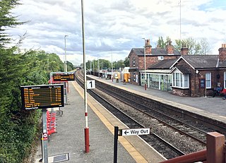
Garforth railway station serves the town of Garforth in West Yorkshire, England. It is one of the two stations in Garforth the other being East Garforth which is situated about 0.5 miles east from the main station and which was opened in 1987. It lies on the Selby Line. Garforth is 7.1 miles (11.5 km) east of Leeds and 16 miles (26 km) south-west of York. The station is served by Northern and TransPennine Express services.

Nailsea and Backwell railway station, on the Bristol to Exeter line, is in the village of Backwell, close to the town of Nailsea in North Somerset, England. It is 8 miles (13 km) west of Bristol Temple Meads railway station, and 126 miles (203 km) from London Paddington. The station, opened in 1841 by the Bristol and Exeter Railway, has two platforms but little in the way of facilities. It is managed by Great Western Railway, the seventh company to be responsible for the station, and the third franchise since privatisation in 1997. The company provides all train services at the station, mainly hourly services between Bristol Parkway and Weston-super-Mare, and between Cardiff Central and Taunton.

Temple Footbridge is a pedestrian only bridge near Hurley, Berkshire across the River Thames in England. It connects the Buckinghamshire and Berkshire banks. It crosses the Thames just above Temple Lock.

Clifton Bridge railway station is a former railway station in the Bower Ashton district of Bristol, England, near the River Avon. It was opened in 1867 by the Bristol and Portishead Pier and Railway Company as a single platform stop 3.4 miles (5.5 km) along the line from Bristol to Portishead. It was later taken over by the Great Western Railway and had a second platform added.

Pill railway station was a railway station on the Portishead Branch Line, 7.8 miles (12.6 km) west of Bristol Temple Meads, serving the village of Pill in North Somerset, England. The station was opened by the Bristol and Portishead Pier and Railway Company on 18 April 1867. It had two platforms, on either side of a passing loop, with a goods yard and signal box later additions. Services increased until the 1930s, at which point a half-hourly service operated. However the Portishead Branch was recommended for closure by the Beeching report, and the station was closed on 7 September 1964, although the line saw freight traffic until 1981. Regular freight trains through the station began to run again in 2002 when Royal Portbury Dock was connected to the rail network.

Reston is a railway station in the small village of Reston that serves the wider rural parish of Coldingham and nearby small town of Eyemouth in the eastern Scottish Borders council area. The station is a minor stop on the East Coast Main Line and opened on 23 May 2022 after a £20 million investment. The station is owned by Network Rail and managed by ScotRail, although the latter company does not provide any services to or from the station. It is the second railway station to have been located in the village, having replaced an earlier station that closed in 1964.
YTL Arena Bristol is a proposed 19,000-capacity indoor arena, to be located at the former Filton Airfield’s Brabazon hangar.

Temple Quay is an area of mixed-use development in central Bristol, England. The project was initiated by Bristol Development Corporation in 1989, under the name Quay Point until 1995. In that year it was handed over to English Partnerships, under whom development eventually started in 1998. It is bounded by Temple Way to the west and Bristol Temple Meads railway station to the southeast; to the northeast the development was bounded by Bristol Floating Harbour until 2002, when development of Temple Quay North started on the harbour's other side. In 2012 the whole area became part of Bristol Temple Quarter Enterprise Zone.

Finzels Reach is a 4.7-acre (1.9 ha) mixed use development site located in central Bristol, England, on a former industrial site, which occupies most of the south bank of Bristol Floating Harbour between Bristol Bridge and St Philip's Bridge, across the river from Castle Park.
The East Beach Bridge is a footbridge which crosses the River Lossie and connects Lossiemouth to the East Beach. The present bridge was opened in 2022 and replaced an older structure.
Bishopmill Bridge is a road bridge in Elgin, Moray, Scotland.

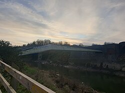
Brock's Bridge is a road bridge in Bristol, UK that crosses the River Avon. It was built to provide road access to a former railway depot that was the original planned site of the Bristol Arena.

Vauxhall Bridge is a footbridge in Bristol, England, that crosses the New Cut of the River Avon. At its northern end, the bridge also passes over the Bristol Harbour Railway line from Ashton Gate to Wapping Wharf, which runs along the bank of the New Cut at this point. The bridge was opened in 1900, replacing the Vauxhall ferry. On 30 December 1994, it was Grade II listed. The bridge closed for repairs on 2 October 2023, and is expected to remain closed for up to two years.
Kingsweston Iron Bridge is a footbridge in Sea Mills, Bristol, UK, that crosses the B4057.