
East Devon is a local government district in Devon, England. Its council is based in the town of Honiton, although Exmouth is the largest town. The district also contains the towns of Axminster, Budleigh Salterton, Cranbrook, Ottery St Mary, Seaton and Sidmouth, along with numerous villages and surrounding rural areas.

Purbeck was a local government district in Dorset, England. The district was named after the Isle of Purbeck, a peninsula that forms a large proportion of the district's area. However, it extended significantly further north and west than the traditional boundary of the Isle of Purbeck which is the River Frome. The district council was based in the town of Wareham, which is itself north of the Frome.

West Orchard is a small village and civil parish in the county of Dorset in southern England. It is situated in the Blackmore Vale in the North Dorset administrative district, approximately halfway between the towns of Shaftesbury and Sturminster Newton. It is separated from the adjacent settlement of East Orchard by a stream. In 2013 the civil parish had an estimated population of 50. For local government purposes the parish is grouped with the parishes of East Orchard and Margaret Marsh, to form a Group Parish Council.

Winterborne Houghton is a village and civil parish in north Dorset, England. It is situated in a winterbourne valley on the Dorset Downs, five miles southwest of Blandford Forum. In the 2011 census the parish had 82 households and a population of 183. In 2001 the population was 195.

Wootton Fitzpaine is a village and civil parish in the county of Dorset in South West England. It lies approximately 3 miles (4.8 km) north-east of Lyme Regis in a small side valley of the River Char, close to the Marshwood Vale. The civil parish covers an area of 3,307 acres (1,338 ha) and includes the ecclesiastical parish and small settlement of Monkton Wyld to the west. In the 2011 census the civil parish had 180 dwellings, 134 households and a population of 345.
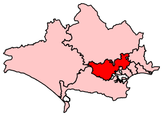
Mid Dorset and North Poole is a constituency represented in the House of Commons of the UK Parliament since 2015 by Michael Tomlinson, a Conservative.

Church Ope Cove is a small secluded beach on the sheltered eastern side of the Isle of Portland in Dorset, southern England, and is part of the Jurassic Coast. It is found close to the village of Wakeham. The beach has many unusual features for the Isle of Portland. The beach used to be sandy, but quarry debris now covers the sand, and has been worn into rounded pebbles. The pebbles cover a small stream which runs to the sea, which is one of the few active streams remaining on the Isle of Portland.

Coade stone or Lithodipyra or Lithodipra is stoneware that was often described as an artificial stone in the late 18th and early 19th centuries. It was used for moulding neoclassical statues, architectural decorations and garden ornaments of the highest quality that remain virtually weatherproof today.
Benjamin Ferrey FSA FRIBA was an English architect who worked mostly in the Gothic Revival.
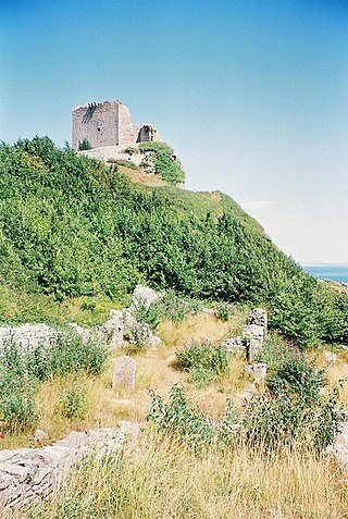
Rufus Castle, also known as Bow and Arrow Castle, is a partially ruined castle overlooking Church Ope Cove on Portland, England. Its name derives from King William II, known as William Rufus, for whom the original castle was built.
Charborough is an historic former parish and manor in Dorset, England. It survives today as a hamlet, situated on an affluent of the River Stour, 6 miles west of Wimborne Minster, but without any of its former administrative powers, and is today part of the parish of Morden. The surviving former parish church is dedicated to Saint Mary. The manor house survives as Charborough House.
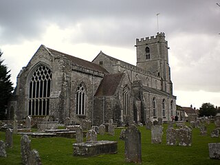
The parish church of Lady St. Mary, Wareham is a church of Anglo-Saxon origin in the town of Wareham, Dorset, in England. The church is notable as the possible burial place of King Beorhtric, and for the discovery of five stones with Brittonic inscriptions dating to the 7th to 9th centuries. A notable feature is the unique hexagonal lead font dating to around 1200. The Anglo-Saxon nave was demolished in 1842.

St. Peter's Church is a former Church of England church in The Grove, on the Isle of Portland, Dorset. Designed by Major-General Sir Edmund Du Cane, the church was built in 1870-72 and is now a Grade II* Listed building. The gate piers and boundary walls to the north and west of the church are also Grade II Listed, along with the church's vicarage. St. Peter's Church is included on English Heritage's "Heritage at Risk" register.

The George Inn is a Grade II-listed 18th-century public house on the Isle of Portland, Dorset, England. It is situated within the village of Easton, at the west end of the hamlet of Reforne. The pub is located close to St George's Church and St George's Centre.

Queen Anne House is an 18th-century detached house located within the village of Fortuneswell, on the Isle of Portland, Dorset, England. The house, together with its boundary wall and gate piers, has been a Grade II* listed building since May 1993.

St. John's Church is an Anglican Church of England church in Fortuneswell, on the Isle of Portland, Dorset. It was built between 1838–40 and has been a Listed Grade II building since January 1951. The churchyard walls, gate piers, railings, and steps of St. John's Church, dating from 1839–40, became Grade II Listed in September 1978. At this same time, two headstone monuments, about 5 metres north east from the west tower of the church became Grade II Listed.

The Church of St Luke, High Orchard, Gloucester, was a Church of England church built and endowed by the Reverend Samuel Lysons, rector of Rodmarton, who was also the first minister.

St. Andrew's Church is a Grade II listed Gothic Victorian church in Richmond Hill, Bournemouth, Dorset, England. A United Reformed church, it is noted for being the largest church in the town.
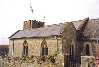
St Peter's Church is a Grade II listed church in the village of Langton Herring, Dorset, England. The church stands behind The Elm Tree Inn public house.
