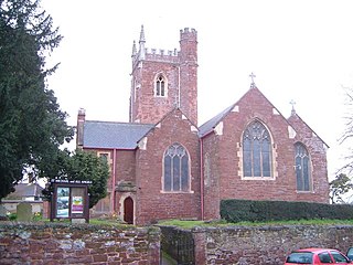
East Devon is a local government district in Devon, England. Its council is based in the town of Honiton, although Exmouth is the largest town. The district also contains the towns of Axminster, Budleigh Salterton, Cranbrook, Ottery St Mary, Seaton and Sidmouth, along with numerous villages and surrounding rural areas.

Teignbridge is a local government district in Devon, England. Its council is based in the town of Newton Abbot. The district also includes the towns of Ashburton, Buckfastleigh, Dawlish, Kingsteignton and Teignmouth, along with numerous villages and surrounding rural areas. Teignbridge contains part of the south Devon coastline, including the Dawlish Warren National Nature Reserve. Some of the inland western parts of the district lie within the Dartmoor National Park. It is named after the old Teignbridge hundred.

Heavitree is a historic village and former civil parish situated formerly outside the walls of the City of Exeter in Devon, England, and is today an eastern district of that city. It was formerly the first significant village outside the city on the road to London. It was the birthplace of the librarian Thomas Bodley, and the theologian Richard Hooker, and from the 16th century to 1818 was a site for executions within what is now the car park of the St Luke's Campus of the University of Exeter.

Exeter is a constituency composed of the cathedral city and county town of Devon represented in the House of Commons of the UK Parliament. The constituency has had a history of representatives from 1900 of Conservative, Liberal Party, Independent and Labour representation.

Beaford is a village and civil parish in the Torridge district of Devon, England. The village is about five miles south-east of Great Torrington, on the A3124 road towards Exeter. According to the 2001 census the parish had a population of 393, compared to 428 in 1901. The western boundary of the parish is formed by the River Torridge and it is surrounded, clockwise from the north, by the parishes of St Giles in the Wood, Roborough, Ashreigney, Dolton, Merton and Little Torrington.

Exmouth Town Football Club is a football club based in Exmouth, Devon, England. They are currently members of the Southern League Division One South and play at Southern Road.

Budleigh Salterton Association Football Club is a football club based in Budleigh Salterton, Devon, England. They are currently members of the Devon League and play at Greenway Lane.

Crediton United Association Football Club is a football club based in Crediton, Devon, England. They are currently members of the South West Peninsula League Premier Division East and play at Lords Meadow.

Tedburn St Mary is a village and civil parish in the Teignbridge district of Devon, England, approximately 8 miles west of Exeter. It has a population of approximately 1500. The village is the principal population centre of the electoral ward called Teignbridge North. The population of the ward at the 2011 census is 2,715.

St Thomas is an area of Exeter and formerly a 3,700-acre (15 km2) civil parish and registration district in Devon, England, on the western side of the River Exe, connected to Exeter by Exe Bridge. It has a number of pubs, places of worship, several schools and a large shopping precinct. The population, according to the 2001 census, is 6,246, increasing to 6,455 at the 2011 Census.

Alphington is a former manor and village, now a suburb of the City of Exeter in Devon. The ward of Alphington has a population of 8,250 according to the 2001 census, making it the third largest in Exeter, with the village itself accounting for about a quarter of this figure. The ward population increased to 8,682 at the 2011 census. It is surrounded on two sides by countryside, with the Marsh Barton trading estate to the east and Exeter City to the north. The Alphin Brook passes around the northern edge of Alphington. Alphington is on the south-western side of Exeter.

St Luke's Campus is a small university campus which is part of the University of Exeter. The School of Sport and Health Sciences, the Graduate School of Education, and the Medical School are all based at St Luke's.
There are 22 disused railway stations on the Bristol to Exeter line between Bristol Temple Meads and Exeter St Davids. The line was completed in 1844 at which time the temporary terminus at Beambridge was closed. The most recent closure was Tiverton Junction which was replaced by a new station} on a different site in 1986. 12 of the disused stations have structures that can still be seen from passing trains.
Millbrook House is a training centre for disabled people in Exeter, Devon, England founded in 1937 by Dame Georgiana Buller. It was the first school dedicated to occupational therapy training in the United Kingdom.

Shillingford St. George is a village on the outskirts of Exeter, East Devon, England. It is about 3 miles south of the City of Exeter.

West Exe School is a coeducational secondary school located in Exeter, with a catchment area covering St Thomas, Alphington, and some parts of Exwick.

Lanteglos is a coastal civil parish in south Cornwall, England, United Kingdom. It is on the east side of the tidal estuary of the River Fowey which separates it from the town and civil parish of Fowey. The South West Coast Path runs along the southern coasts of the parish and much of the southern part of the parish lies in the Polruan to Polperro Site of Special Scientific Interest managed by the National Trust.

Clyst St Lawrence is a village and civil parish about 8 miles north-east of the city of Exeter in the county of Devon, England. Historically it formed part of Cliston Hundred. The parish is in the East Devon district and is surrounded, clockwise from the north, by the parishes of Clyst Hydon, Whimple and the large parish of Broad Clyst. In 2001 its population was 105, little changed from the 113 people who lived there in 1901.

St Pancras Church is a small church situated in the middle of the Guildhall Shopping Centre in Exeter. The majority of the church dates from the thirteenth century, although the font is eleventh century. The church probably occupies the oldest Christian site in Exeter, and is usually open on weekdays. The church is designated by English Heritage as a Grade II* listed building.


