
In mechanics, acceleration is the rate of change of the velocity of an object with respect to time. Accelerations are vector quantities. The orientation of an object's acceleration is given by the orientation of the net force acting on that object. The magnitude of an object's acceleration, as described by Newton's Second Law, is the combined effect of two causes:
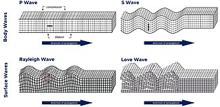
A seismic wave is a wave of acoustic energy that travels through the Earth or another planetary body. It can result from an earthquake, volcanic eruption, magma movement, a large landslide, and a large man-made explosion that produces low-frequency acoustic energy. Seismic waves are studied by seismologists, who record the waves using seismometers, hydrophones, or accelerometers. Seismic waves are distinguished from seismic noise, which is persistent low-amplitude vibration arising from a variety of natural and anthropogenic sources.

A seismic hazard is the probability that an earthquake will occur in a given geographic area, within a given window of time, and with ground motion intensity exceeding a given threshold. With a hazard thus estimated, risk can be assessed and included in such areas as building codes for standard buildings, designing larger buildings and infrastructure projects, land use planning and determining insurance rates. The seismic hazard studies also may generate two standard measures of anticipated ground motion, both confusingly abbreviated MCE; the simpler probabilistic Maximum Considered Earthquake, used in standard building codes, and the more detailed and deterministic Maximum Credible Earthquake incorporated in the design of larger buildings and civil infrastructure like dams or bridges. It is important to clarify which MCE is being discussed.
Seismic tomography is a technique for imaging the subsurface of the Earth with seismic waves produced by earthquakes or explosions. P-, S-, and surface waves can be used for tomographic models of different resolutions based on seismic wavelength, wave source distance, and the seismograph array coverage. The data received at seismometers are used to solve an inverse problem, wherein the locations of reflection and refraction of the wave paths are determined. This solution can be used to create 3D images of velocity anomalies which may be interpreted as structural, thermal, or compositional variations. Geoscientists use these images to better understand core, mantle, and plate tectonic processes.

Reflection seismology is a method of exploration geophysics that uses the principles of seismology to estimate the properties of the Earth's subsurface from reflected seismic waves. The method requires a controlled seismic source of energy, such as dynamite or Tovex blast, a specialized air gun or a seismic vibrator. Reflection seismology is similar to sonar and echolocation.
In probability and statistics, the parabolic fractal distribution is a type of discrete probability distribution in which the logarithm of the frequency or size of entities in a population is a quadratic polynomial of the logarithm of the rank. This can markedly improve the fit over a simple power-law relationship.

A P wave is one of the two main types of elastic body waves, called seismic waves in seismology. P waves travel faster than other seismic waves and hence are the first signal from an earthquake to arrive at any affected location or at a seismograph. P waves may be transmitted through gases, liquids, or solids.

In geophysics and reflection seismology, amplitude versus offset (AVO) or amplitude variation with offset is the general term for referring to the dependency of the seismic attribute, amplitude, with the distance between the source and receiver. AVO analysis is a technique that geophysicists can execute on seismic data to determine a rock's fluid content, porosity, density or seismic velocity, shear wave information, fluid indicators.
Exploration geophysics is an applied branch of geophysics and economic geology, which uses physical methods at the surface of the Earth, such as seismic, gravitational, magnetic, electrical and electromagnetic, to measure the physical properties of the subsurface, along with the anomalies in those properties. It is most often used to detect or infer the presence and position of economically useful geological deposits, such as ore minerals; fossil fuels and other hydrocarbons; geothermal reservoirs; and groundwater reservoirs. It can also be used to detect the presence of unexploded ordnance.
Seismic anisotropy is the directional dependence of the velocity of seismic waves in a medium (rock) within the Earth.
Systemic is a research project designed to search data for extrasolar planets using amateur astronomers. The project utilizes a downloaded console provided on the Systemic website, allowing users to sort through data sets in search of characteristics which may reveal the presence of a planet within a planetary system.
The plus-minus method, also known as CRM, is a geophysical method to analyze seismic refraction data developed by J. G. Hagedoorn. It can be used to calculate the depth and velocity variations of an undulating layer boundary for slope angles less than ~10°.
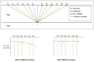
In reflection seismology, normal moveout (NMO) describes the effect that the distance between a seismic source and a receiver has on the arrival time of a reflection in the form of an increase of time with offset. The relationship between arrival time and offset is hyperbolic and it is the principal criterion that a geophysicist uses to decide whether an event is a reflection or not. It is distinguished from dip moveout (DMO), the systematic change in arrival time due to a dipping layer.
In geophysics, seismic inversion is the process of transforming seismic reflection data into a quantitative rock-property description of a reservoir. Seismic inversion may be pre- or post-stack, deterministic, random or geostatistical; it typically includes other reservoir measurements such as well logs and cores.

Seismic inversion involves the set of methods which seismologists use to infer properties through physical measurements. Surface-wave inversion is the method by which elastic properties, density, and thickness of layers in the subsurface are obtained through analysis of surface-wave dispersion. The entire inversion process requires the gathering of seismic data, the creation of dispersion curves, and finally the inference of subsurface properties.
The motion of an object moving in a curved path is called curvilinear motion. Example: A stone thrown into the air at an angle.
Semblance analysis is a process used in the refinement and study of seismic data. The use of this technique along with other methods makes it possible to greatly increase the resolution of the data despite the presence of background noise. The new data received following the semblance analysis is usually easier to interpret when trying to deduce the underground structure of an area. Weighted semblance can be used for increasing the resolution of traditional semblance or make traditional semblance capable of analyzing more complicated seismic data.

The preliminary reference Earth model (PREM) plots the average of Earth's properties by depth. It includes a table of Earth properties, including elastic properties, attenuation, density, pressure, and gravity.

The Adare Basin is a geologic structural basin located north-east of Cape Adare of Antarctica, for which its named, and north of the western Ross Sea. The Adare Basin is an extensional rift basin located along a seafloor spreading center that forms the failed arm of the Tertiary spreading ridge separating East and West Antarctica, known as the West Antarctic Rift System and similar in structure to the East Africa Rift System. Centrally located in the Adare Basin is the Adare Trough. The extension of this rift system is recorded in a series of magnetic anomalies which run along the seafloor at the extinct, north–south trending, Adare spreading axis. The Adare spreading system continues unbroken into the Northern Basin underlying the adjacent Ross Sea continental shelf.
Reinhard Bortfeld was a German geophysicist.