
Navigation is a field of study that focuses on the process of monitoring and controlling the movement of a craft or vehicle from one place to another. The field of navigation includes four general categories: land navigation, marine navigation, aeronautic navigation, and space navigation.

Celestial navigation, also known as astronavigation, is the ancient and modern practice of position fixing that enables a navigator to transition through a space without having to rely on estimated calculations, or dead reckoning, to know their position. Celestial navigation uses "sights", or angular measurements taken between a celestial body and the visible horizon. The Sun is most commonly used, but navigators can also use the Moon, a planet, Polaris, or one of 57 other navigational stars whose coordinates are tabulated in the nautical almanac and air almanacs.

A kamal is a celestial navigation device that determines latitude. The invention of the kamal allowed for the earliest known latitude sailing, and was thus the earliest step towards the use of quantitative methods in navigation. It originated with Arab navigators of the late 9th century, and was employed in the Indian Ocean from the 10th century. It was adopted by Indian navigators soon after, and then adopted by Chinese navigators some time before the 16th century.

A laser rangefinder is a rangefinder that uses a laser beam to determine the distance to an object. The most common form of laser rangefinder operates on the time of flight principle by sending a laser pulse in a narrow beam towards the object and measuring the time taken by the pulse to be reflected off the target and returned to the sender. Due to the high speed of light, this technique is not appropriate for high precision sub-millimeter measurements, where triangulation and other techniques are often used.

The term Jacob's staff, also known as cross-staff, a ballastella, a fore-staff, or a balestilha, is used to refer to several things. In its most basic form, a Jacob's staff is a stick or pole with length markings; most staffs are much more complicated than that, and usually contain a number of measurement and stabilization features. The two most frequent uses are:

The octant, also called reflecting quadrant, is a measuring instrument used primarily in navigation. It is a type of reflecting instrument.

Gun laying is the process of aiming an artillery piece, such as a gun, howitzer, or mortar, on land or at sea, against surface or air targets. It may be laying for direct fire, where the gun is aimed similarly to a rifle, or indirect fire, where firing data is calculated and applied to the sights. The term includes automated aiming using, for example, radar-derived target data and computer-controlled guns.

A coordinate measuring machine (CMM) is a device that measures the geometry of physical objects by sensing discrete points on the surface of the object with a probe. Various types of probes are used in CMMs, including mechanical, optical, laser, and white light. Depending on the machine, the probe position may be manually controlled by an operator or it may be computer controlled. CMMs typically specify a probe's position in terms of its displacement from a reference position in a three-dimensional Cartesian coordinate system. In addition to moving the probe along the X, Y, and Z axes, many machines also allow the probe angle to be controlled to allow measurement of surfaces that would otherwise be unreachable.

A level is an optical instrument used to establish or verify points in the same horizontal plane in a process known as levelling, and is used in conjunction with a levelling staff to establish the relative heights levels of objects or marks. It is widely used in surveying and construction to measure height differences and to transfer, measure, and set heights of known objects or marks.

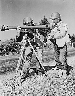
A height finder is a ground-based aircraft altitude measuring device. Early height finders were optical range finder devices combined with simple mechanical computers, while later systems migrated to radar devices. The unique vertical oscillating motion of height finder radars led to them also being known as nodding radar. Devices combining both optics and radar were deployed by the U.S. Military.
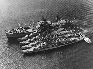
A destroyer tender, or destroyer depot ship in British English, is an auxiliary ship designed to provide maintenance support to a flotilla of destroyers or other small warships. The use of this class has faded from its peak in the first half of the 20th century as the roles of small combatants have evolved.
In naval gunnery, when long-range guns became available, an enemy ship would move some distance after the shells were fired. It became necessary to figure out where the enemy ship, the target, was going to be when the shells arrived. The process of keeping track of where the ship was likely to be was called rangekeeping, because the distance to the target—the range—was a very important factor in aiming the guns accurately. As time passed, train, the direction to the target, also became part of rangekeeping, but tradition kept the term alive.
Sextants for astronomical observations were devices depicting a sixth of a circle, used primarily for measuring the positions of stars. They are of significant historical importance, but have been replaced over time by transit telescopes, astrometry techniques, and satellites such as Hipparcos.
Reflecting instruments are those that use mirrors to enhance their ability to make measurements. In particular, the use of mirrors permits one to observe two objects simultaneously while measuring the angular distance between the objects. While reflecting instruments are used in many professions, they are primarily associated with celestial navigation as the need to solve navigation problems, in particular the problem of the longitude, was the primary motivation in their development.
A coincidence rangefinder is a type of rangefinder that uses mechanical and optical principles to allow an operator to determine the distance to a visible object.

Ship gun fire-control systems (GFCS) are fire-control systems to enable remote and automatic targeting of guns against surface ships, aircraft, and shore targets, with either optical or radar sighting.
Tree height is the vertical distance between the base of the tree and the tip of the highest branch on the tree, and is difficult to measure accurately. It is not the same as the length of the trunk. If a tree is leaning, the trunk length may be greater than the height of the tree. The base of the tree is where the projection of the pith (center) of the tree intersects the existing supporting surface upon which the tree is growing or where the acorn sprouted. If the tree is growing on the side of a cliff, the base of the tree is at the point where the pith would intersect the cliff side. Roots extending down from that point would not add to the height of the tree. On a slope this base point is considered as halfway between the ground level at the upper and lower sides of the tree. Tree height can be measured in a number of ways with varying degrees of accuracy.


