
St. Louis County is a county located in the Arrowhead Region of the U.S. state of Minnesota. As of the 2020 census, the population was 200,231. Its county seat is Duluth. It is the largest county in Minnesota by land area, and the largest in the United States by total area east of the Mississippi River. St. Louis County is included in the Duluth, MN–Superior, WI Metropolitan Statistical Area.
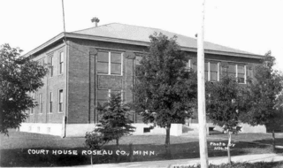
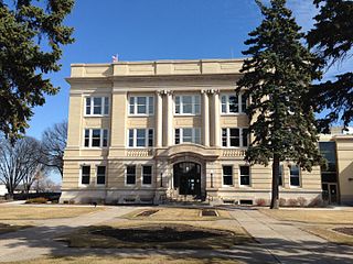
Roseau County is a county in the northwestern part of the U.S. state of Minnesota, along the Canada–US border. As of the 2020 census, the population was 15,331. Its county seat is Roseau. Roseau County borders the Canadian province of Manitoba.
Otter Tail County is a county in the U.S. state of Minnesota. As of the 2020 census, its population was 60,081. Its county seat is Fergus Falls. Otter Tail County comprises the Fergus Falls micropolitan statistical area. With 1,048 lakes in its borders, Otter Tail County has more lakes than any other county in the United States.

Nobles County is a county in the U.S. state of Minnesota. As of the 2020 census, the population was 22,290. Its county seat is Worthington. Nobles County comprises the Worthington, MN Micropolitan Statistical Area.

Mahnomen County is a county in the U.S. state of Minnesota. As of the 2020 census, the population was 5,411. Its county seat is Mahnomen.

Freeborn County is a county in the state of Minnesota. As of the 2020 census, the population was 30,895. Its county seat is Albert Lea. Freeborn County comprises the Albert Lea Micropolitan Statistical Area.

Cass County is a county in the central part of the U.S. state of Minnesota. As of the 2020 census, the population was 30,066. Its county seat is Walker. The county was formed in 1851, and was organized in 1897.

Becker County is a county in the U.S. state of Minnesota. As of the 2020 census, the population was 35,183. Its county seat is Detroit Lakes. Part of the White Earth Indian Reservation extends into the county. The county was created in 1858 and organized in 1871.
Lake View Township is a township in Becker County, Minnesota, United States. The population was 1,685 at the 2010 census.
Buzzle Township is a township in Beltrami County, Minnesota, United States. The population was 286 as of the 2000 census. Buzzle Township took its name from Buzzle Lake.
Roosevelt Township is a township in Beltrami County, Minnesota, United States. The population was 219 as of the 2000 census.

The Northwest Angle, known simply as the Angle by locals, and coextensive with Angle Township, is a pene-exclave of northern Lake of the Woods County, Minnesota. Except for surveying errors, it is the only place in the contiguous United States north of the 49th parallel, which forms the border between the U.S. and Canada from the Northwest Angle westward to the Strait of Georgia. The land area of the Angle is separated from the rest of Minnesota by Lake of the Woods, but shares a land border with Canada. It is one of six non-island locations in the 48 contiguous states that are practical exclaves of the U.S. It is the northernmost township in Minnesota and contains the northernmost point in the contiguous 48 states. The unincorporated community of Angle Inlet is in the Northwest Angle.

The Canada–United States border is the longest international border in the world. The boundary is 8,891 km (5,525 mi) long. The land border has two sections: Canada's border with the contiguous United States to its south, and with the U.S. state of Alaska to its west. The bi-national International Boundary Commission deals with matters relating to marking and maintaining the boundary, and the International Joint Commission deals with issues concerning boundary waters. The agencies responsible for facilitating legal passage through the international boundary are the Canada Border Services Agency (CBSA) and U.S. Customs and Border Protection (CBP).
Mille Lacs Indian Reservation is the popular name for the land-base for the Mille Lacs Band of Ojibwe in Central Minnesota, about 100 miles (160 km) north of Minneapolis-St. Paul. The contemporary Mille Lacs Band reservation has significant land holdings in Mille Lacs, Pine, Aitkin and Crow Wing counties, as well as other land holdings in Kanabec, Morrison, and Otter Tail Counties. Mille Lacs Indian Reservation is also the name of a formal Indian reservation established in 1855. It is one of the two formal reservations on which the contemporary Mille Lacs Band retains land holdings. The contemporary Mille Lacs band includes several aboriginal Ojibwe bands and villages, whose members reside in communities throughout central Minnesota.
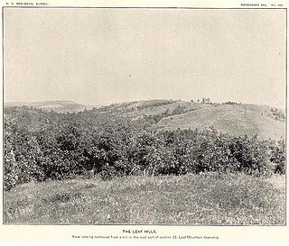
The Leaf Hills Moraines, sometimes called the Leaf Mountains, are a range of hills in west-central Minnesota. The land does not exhibit many characteristics of mountains, but nevertheless rises typically to a height of 100 to 300 feet above the surrounding farmland, occasionally reaching higher than 350 feet (107 m). The name of this range of hills is translated from the Ojibwe Gaaskibag-wajiwan, which was interpreted by Gilfillan as “Rustling Leaf Mountains.” The name is also shared by Leaf Mountain Township, the two Leaf Lakes ("Gaaskibag-wajiwi-zaaga'iganan"), and the Leaf River ("Gaaskibag-wajiwi-ziibi"), all named for the hills. In turn, the hills in Ojibwe are named after Inspiration Peak ("Gaaskibag-wajiw"), a prominent hill in this area.

Inspiration Peak is a glacial feature of the Leaf Hills Moraines and of Otter Tail County in the U.S. State of Minnesota and is the second highest peak in Otter Tail County. It is 22 miles (35 km) northwest of Alexandria. The peak rises about 310 feet (94 m) above the surrounding plains, to an elevation of about 1,727 feet (526 m) above sea level. It is the central feature of Inspiration Peak State Wayside, a small recreation area maintained by the Minnesota Department of Natural Resources, which manages it from nearby Lake Carlos State Park. The wayside has a paved parking lot and a picnic area. The hike to the top is a short but strenuous walk up a well-worn trail from the parking lot. Higher terrain is located about five miles northeast of Inspiration Peak. Pekan Peak in Section 32, Folden Township, Otter Tail County, discovered by John Sandy in February 2022, at coordinates 46°11′54.744″ N 95°30′4.248″ W (DMS), Latitude 46.19854 Longitude -95.50118 (DD), has an elevation of 1,800.05 feet, measured by LiDAR technology.
Oak Lake is a ghost town in section 24 of Audubon Township in Becker County, Minnesota, United States.

Wakarusa Township is a township in Douglas County, Kansas, USA. As of the 2010 census, its population was 2,318. It was named for the Wakarusa River which flows through Douglas County from Wabaunsee County to the Kansas River near Eudora.
Viola Township is a township in Osceola County, Iowa, United States. Viola Township is located on the Minnesota-Iowa border.
Union Township is a township in Woodbury County, Iowa, United States.


