Related Research Articles

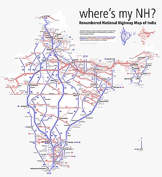
National Highway 16 also known as Kolkata - Chennai Highway is a major National Highway in India that runs along east coast of West Bengal, Odisha, Andhra Pradesh, and Tamil Nadu. It was previously known as National Highway 5.
Muniguda, located 60 km from Rayagada, is a town in the Rayagada district in the Indian state of Odisha
Bhaliapadar is a small village under Muniguda Block in the Rayagada district, Odisha India.
Hatamuniguda is an underdeveloped village of Rayagada district, Odisha, India - 765020. The village is 43 km far from its district main city Rayagada. Hatamuniguda is 258 km far from its state main city Bhubaneswar.
Bissam Cuttack is a Vidhan Sabha constituency of Rayagada district, Odisha.

National Highway 55 is a National Highway in India connecting Sambalpur and Cuttack in Indian state of Odisha. Starting from NH 53 in Maneswar, Sambalpur, it terminates at NH 16, in Manguli Square, Cuttack. it is also known as Cuttack - Sambalpur Highway. Before renumbering of national highways of India, route of NH-55 was part of old national highway 42. This national highway is 263 km (163 mi) long.
National Highway 49 is a primary National Highway in India. This highway runs from Bilaspur in the Indian state of Chhattisgarh to Kharagpur in West Bengal. Starting from NH 130 near Bilaspur, it terminates at NH 16 near Kharagpur, West Bengal. The highway is part of AH46 network in India. This national highway is 668 km (415 mi) long.

National Highway 59 is a National Highway in India connecting Khariar and Brahmapur in the state of Odisha. Before renumbering of national highways, route of NH-59 was part of old national highway 217. The Highway is connected with SH 42 of Odisha State near Bangomunda.
National Highway 220, commonly referred to as NH 220 is a national highway in India. It is a spur road of National Highway 20. NH-220 traverses the states of Jharkhand and Odisha in India. Prior to new numbering system of national highways adopted in 2018, the current NH 183 in Kerala was referred to as NH 220.

National Highway 57, previously numbered as NH 224, is a primary National Highway in India connecting Balangir and Khordha in the state of Odisha.

National Highway 153B, commonly referred to as NH 153B is a national highway in India. It is a spur road of National Highway 53. NH-153B traverses the state of Odisha in India.
National Highway 157, commonly referred to as NH 157 is a national highway in India. It is a spur road of National Highway 57. NH-157 traverses the state of Odisha in India.
National Highway 130C, commonly referred to as NH 130C is a national highway in India. It is a spur road of National Highway 30. NH-130C traverses the states of Chhattisgarh and Maharashtra in India.
National Highway 130CD, commonly referred to as NH 130CD is a national highway in India. It is a spur road of National Highway 30. NH-130CD traverses the states of Odisha and Chhattisgarh in India.
National Highway 157A, commonly referred to as NH 157A is a national highway in India. It is a secondary route of National Highway 57. NH-157A runs in the state of Odisha in India.
National Highway 126A, commonly referred to as NH 126A is a national highway in India. It is a secondary route of National Highway 26. NH-126A runs in the state of Odisha in India.
National Highway 655, commonly referred to as NH 655 is a national highway in India. It is a secondary route of National Highway 55. NH-655 runs in the state of Odisha in India.

National Highway 720, commonly referred to as NH 720, is a national highway in India. It is a secondary route of National Highway 20. NH-720 runs in the state of Odisha in India.
National Highway 143H, commonly referred to as NH 143H is a national highway in India. It is a secondary route of National Highway 43. NH-143H runs in the states of Odisha and Jharkhand in India.
Muniguda railway station is a railway station on the East Coast Railway network in the state of Odisha, India. It serves Muniguda town. Its code is MNGD. It has three platforms. Passenger, Express and Superfast trains halt at Muniguda railway station.
References
- ↑ Maps (Map). Google Maps.