Related Research Articles

Staten Island Mall is a shopping mall in New Springville, Staten Island, New York City, opened in 1973. It is the only indoor shopping mall in the borough. It is the largest retail center on the island and is the site of the island's third-largest public transit hub after the St. George Terminal and Eltingville Transit Center, with numerous bus routes that connect to the periphery of the mall area. It is the second largest shopping center in New York City. The mall features Primark, JCPenney, and Macy's, in addition to an 11-screen dine-in AMC Theatres.
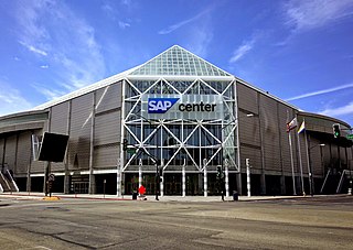
The SAP Center at San Jose is an indoor arena located in San Jose, California. Its primary tenant is the San Jose Sharks of the National Hockey League, for which the arena has earned the nickname "The Shark Tank".

State Farm Arena is a multi-purpose arena located in Atlanta, Georgia. The arena serves as the home venue for the Atlanta Hawks of the National Basketball Association (NBA). It also served as home to the Atlanta Thrashers of the National Hockey League from 1999 to 2011, before the team moved to Winnipeg, as well as the Atlanta Dream of the Women's National Basketball Association (WNBA) from 2008 to 2016 and 2019, and the temporary home of Georgia Tech basketball in 2011. It opened in 1999 as Philips Arena at a cost of $213.5 million, replacing the Omni Coliseum. It is owned by the Atlanta Fulton County Recreation Authority and operated by the Hawks, owned by Tony Ressler along with a group of investors including Grant Hill.

The Wells Fargo Center is a multi-purpose indoor arena located in Philadelphia. It serves as the home of the Philadelphia Flyers of the National Hockey League (NHL), the Philadelphia 76ers of the National Basketball Association (NBA), and the Philadelphia Wings of the National Lacrosse League (NLL). The arena lies at the southwest corner of the South Philadelphia Sports Complex, which includes Lincoln Financial Field, Citizens Bank Park, and Xfinity Live!.

Scotiabank Centre is the largest multi-purpose facility in Atlantic Canada, located in downtown Halifax, Nova Scotia, Canada. The main entrances to the building are located on Brunswick Street, at the corner of Duke Street and Carmichael Street, at the foot of Citadel Hill. The building's box office entrance is located on Carmichael Street.

St. George Cricket Grounds or more properly just St. George Grounds is a former baseball venue located on Staten Island, New York. St. George was the home park for the New York Metropolitans of the American Association for the 1886 and 1887 seasons. The grounds were also a part-time home to the New York Giants of the National League in 1889.
Credit Union 1 Arena is a multi-purpose arena located at 525 S. Racine Avenue on the Near West Side in Chicago, Illinois. It opened in 1982.
Staten Island Academy is a coeducational, college-preparatory day school located on a 14-acre (57,000 m2) campus in Staten Island, New York City, United States. Founded in 1884 by Anton Methfessel, it is the oldest independent school on Staten Island, and is the only independent school in the borough. It educates students from Pre-Kindergarten through Grade 12. The current enrollment is around 390 students, with a student to teacher ratio of 7:1. Eileen Corigliano is the current head of school. The school is composed of three divisions: Lower School, Pre-K-Gr. 4; Middle School, Gr. 5-8; Upper School, Gr. 9-12. The Head of Lower, Middle and Upper School is Eileen Corigliano. The campus has seven buildings: the Early Childhood Building, the Art Barn, Haugen Hall, Kearns Hall, Crowe Hall, Alumni Hall and the OJ Buck Gymnasium. The school's accreditations include the Middle States Association of Colleges and Schools, and the New York State Association of Independent Schools. It is chartered and registered by the Board of Regents, University of the State of New York.

Walter Brown Arena is a 3,806-seat multi-purpose arena in Boston, Massachusetts. It is home to the Boston University Terriers women's ice hockey team and hosted the men's team before they moved to Agganis Arena. It is named in honor of Walter A. Brown, the original owner of the Boston Celtics, former president of the Boston Bruins and second manager of the Boston Garden. The arena is part of the Harold Case Physical Education Center, which includes Case Gym directly above the arena, as well as the former home of student recreation before the opening of the John Hancock Student Village. The building lies in the general area of the left field pavilion seats at the former Braves Field, whose right field pavilion and a portion of the field have been converted to neighboring Nickerson Field.
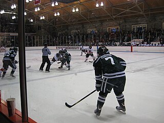
Hobey Baker Memorial Rink is a 2,092-seat hockey arena in Princeton, New Jersey. It is home to the Princeton University Tigers men's and women's ice hockey teams as well as the venue for club and intramural hockey teams, intramural broomball, figure skating and recreational skating. It is the only ice skating rink on the Princeton University campus. It is named in honor of former Princeton star Hobart A.H. "Hobey" Baker, '14. Baker was a football and hockey star who died shortly after World War I. In December 1921, it was decided to build an on-campus arena for the hockey team, and to name it after Baker. Efforts to modernize the arena began in the mid-1970s with major improvements including the addition of locker rooms, a skate sharpening room and a stick storage room in 1981, a new scoreboard and lighting improvements in 1984 and a renovation of the roof in 2002. It is the second-oldest arena still in use in NCAA Division I hockey, behind only Matthews Arena at Northeastern University; however, Northeastern has only played at Matthews Arena since 1930, giving Princeton the distinction of being the school that has played in its current home the longest.
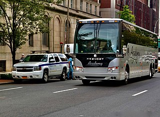
Academy Bus Lines is a bus company in New Jersey providing local bus services in northern New Jersey, line-run services to/from New York City from points in southern and central New Jersey, and contract and charter service in the eastern United States from Boston to Miami. In 2014, Academy acquired Go Buses, which currently operates bus service between Boston and Washington, D.C., and in southern Florida. On September 27, 2023, Academy acquired James River Transportation, which operates in Virginia. Academy is the third-largest motorcoach operator in the United States and Canada.
Oakland Park was a ballpark in The Heights neighborhood of Jersey City, New Jersey. It was the home of the minor league baseball club, the Jersey City Skeeters, from 1888 to 1890. The club briefly disbanded in July 1890, but the park continued to be used by other local teams for several years after. It hosted the New York Giants of Major League Baseball for their first two home games in 1889 following their eviction from the Polo Grounds.

The William G. Mennen Sports Arena, commonly referred to as Mennen Arena, is a multi-purpose arena in Morris Township, New Jersey primarily used for ice hockey and other skating activities. The building houses three regulation-sized ice rinks. The main rink has seating for 2,500 spectators.
The Jake Nevin Field House is an arena located at Villanova University in Villanova, Pennsylvania. The arena, built in 1932, is the former home of the Villanova men's basketball program prior to the construction of the venue now known as Finneran Pavilion in 1986. It currently houses the women's volleyball team, as well as the intramural sports program and the main athletic offices for the school.
Long Pond Park is a park preserve on the South Shore of Staten Island, New York City. It is approximately 115 acres (0.47 km2) in size and consists mainly of woodlands and wetlands that surround Long Pond, for which the park is named. Long Pond Park is roughly bounded by Hylan Boulevard on the south, Page Avenue on the west, Amboy Road on the north, and Richard Avenue on the east. It is an important stopping point for migrating birds in the Atlantic Flyway.

Conference House Park is a park in Tottenville, Staten Island, New York City. The park is located along the Arthur Kill coast where the kill opens into Raritan Bay. It contains clay bluffs, part of the terminal moraine, formed when the Wisconsin Glacier receded 10,000 years ago. Ward's Point, the southernmost point in New York state, is in the park.

Bloomingdale Park is a 138-acre (56 ha) park on the South Shore of Staten Island. It is located in the Prince's Bay neighborhood, and is bounded on the north by Ramona Avenue, on the west by Bloomingdale Road, on the east by Lenevar Avenue, and on the south by Drumgoole Road West and the Korean War Veterans Parkway. It is nearly bisected by Maguire Avenue, but the avenue's two spurs into the park from the north and south do not meet in the middle.
The Staten Island Cricket Club (SICC) is a cricket club on Staten Island, New York, United States, that was incorporated as the Staten Island Cricket and Base Ball Club on March 22, 1872. It became the first tennis venue in the United States.

The South Beach–Franklin Delano Roosevelt Boardwalk, alternately referred to as the FDR Boardwalk or the South Beach Boardwalk, is a boardwalk facing the Lower New York Bay on the East Shore of Staten Island, one of the five boroughs of New York City. The boardwalk is the main feature of a public park that stretches from Fort Wadsworth and the Verrazzano-Narrows Bridge to Miller Field, both part of the Gateway National Recreation Area. The park also contains numerous recreational facilities, including a skate park.
The Penn State Ice Pavilion was a 1,350-seat ice arena on the campus of The Pennsylvania State University located in University Park, Pennsylvania, United States. The ice arena included an NHL regulation sized 200' x 85' ice sheet as well as a 45' x 55' studio ice sheet.
References
- ↑ LeConey, Bill (April 5, 2004). "League to decide today if A.C. must forfeit game". Press of Atlantic City . p. D4. Retrieved January 5, 2024– via Newspapers.com.
- ↑ Jones-Gorman, Jessica (December 9, 2022). "Staten Island Skating Pavilion completes a major renovation: Here's a peek inside". SILive.com. Retrieved January 5, 2024.
40°32′38″N74°13′57″W / 40.54402°N 74.23255°W
| | This article about a sports venue in New York is a stub. You can help Wikipedia by expanding it. |
| | This article about a building or structure in Staten Island is a stub. You can help Wikipedia by expanding it. |
| | This article related to sports in New York City is a stub. You can help Wikipedia by expanding it. |