Related Research Articles

The Via Egnatia was a road constructed by the Romans in the 2nd century BC. It crossed Illyricum, Macedonia, and Thracia, running through territory that is now part of modern Albania, North Macedonia, Greece, and European Turkey as a continuation of the Via Appia.

Roman roads in Britannia were initially designed for military use, created by the Roman army during the nearly four centuries (AD 43–410) that Britannia was a province of the Roman Empire.

The Antonine Itinerary is an itinerarium, a register of the stations and distances along various roads. Seemingly based on official documents, possibly from a survey carried out under Augustus, it describes the roads of the Roman Empire. Owing to the scarcity of other extant records of this type, it is a valuable historical record.
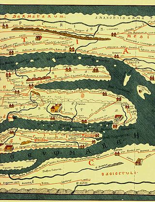
Tabula Peutingeriana, also referred to as Peutinger's Tabula or Peutinger Table, is an illustrated itinerarium showing the layout of the cursus publicus, the road network of the Roman Empire.
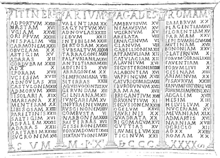
An itinerarium was an ancient Roman travel guide in the form of a listing of cities, villages (vici) and other stops on the way, including the distances between each stop and the next. Surviving examples include the Antonine Itinerary and the Bordeaux Itinerary.

Çorlu is a municipality and district of Tekirdağ Province, northwestern Turkey. Its area is 531 km2, and its population is 290,155 (2022). It is a rapidly growing industrial center built on flatland located on the motorway Otoyol 3 and off the highway D.100 between Istanbul and Turkey's border with Greece and Bulgaria. The nearest airport is Tekirdağ-Çorlu Airport (TEQ). It is the most populated city in Turkey entirely in Europe.
Tabarja is an ancient coastal village in Lebanon, situated in Kesrouan, 26 km (16 mi)
Zaliche or Zaliches (Ζαλίχης) was an ancient town in the late Roman province of Helenopontus.
A statio is the place where, in the Roman Rite, a devotion to the stations of the Cross is celebrated.
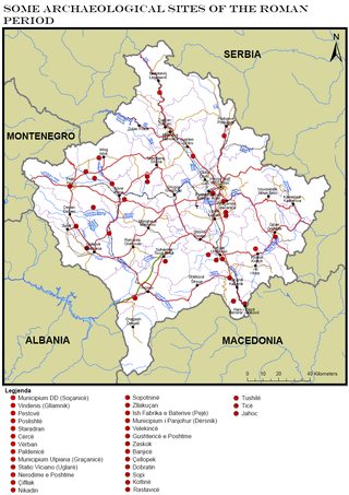
Part of a series of articles upon Archaeology of Kosovo

Imperia is a coastal city and comune in the region of Liguria, Italy. It is the capital of the Province of Imperia, and historically it was capital of the Intemelia district of Liguria. Benito Mussolini created the city of Imperia on 21 October 1923 by combining Porto Maurizio and Oneglia, as well as the surrounding village communes of Piani, Caramagna Ligure, Castelvecchio di Santa Maria Maggiore, Borgo Sant'Agata, Costa d'Oneglia, Poggi, Torrazza, Moltedo and Montegrazie.
Part of a series of articles upon Archaeology of Kosovo
Caenophrurium was a settlement in the Roman province of Europa, between Byzantium and Heraclea Perinthus. It appears in late Roman and early Byzantine accounts. Caenophrurium translates as the "stronghold of the Caeni", a Thracian tribe.
The Stadiasmus Maris Magni is an ancient Roman periplus or guidebook detailing the ports sailors encounter on the shores of the Mediterranean Sea. The stadiasmus provides distances, sailing directions and descriptions of specific ports. It was written in Ancient Greek and survives in fragments. The work was written by an anonymous author and is dated to the second half of the third century AD. The most complete Greek text together with a Latin translation was published in 1855 by Karl Müller as part of his work Geographi Graeci Minores.
Travel in classical antiquity over long distances was a specialised undertaking. Most travel was done in the interest of warfare, diplomacy, general state building, or trade. Social motivations for travel included visiting religious sites, festivals such as the Olympics, and health-related reasons. Most travel was difficult and expensive, due to the danger of violence, the scarcity of well-maintained roads, and the variability of travel times on water, as ancient ships were subject to the vagaries of both the wind and the tides.
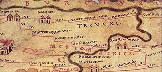
The Roman road from Trier to Cologne is part of the Via Agrippa, a Roman era long distance road network, that began at Lyon. The section from Augusta Treverorum (Trier) to the CCAA (Cologne), the capital of the Roman province of Germania Inferior, had a length of 66 Roman leagues. It is described in the Itinerarium Antonini, the itinerarium by Emperor Caracalla (198–217), which was revised in the 3rd century, and portrayed in the Tabula Peutingeriana or Peutinger Table, the Roman map of the world discovered in the 16th century, which shows the Roman road network of the 4th century.

Tocolsida is a site in modern Morocco, with the remains of an ancient castra from the Roman Province of Mauretania Tingitana, Roman Empire.
Barate, Barata (Βάρατα), or Baratta (Βάραττα), was a town of ancient Lycaonia, on the road from Iconium to Tyana, 50 M.P. from the former. In some itineraria the name is also spelt Barathra. It was inhabited during Roman and Byzantine times.
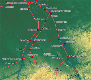
Sablones was a Roman settlement in the province of Germania Inferior, probably near modern-day Kaldenkirchen in Germany, just across the border from Venlo in the Netherlands. The statio is mentioned in the Roman travel guide Antonine Itinerary (Itinerarium Antonini) between Meridacium and Mediolanum and was located on the Roman road from Coriovallum (Heerlen) to Colonia Ulpia Traiana (Xanten).

The Temple of Jupiter Apenninus or Temple of Jupiter Poeninus was an Umbrian-Roman temple that lay at the foot of Monte Catria, near the modern village of Scheggia, between today's Umbria and Marche regions, in Italy. The temple stood near the ancient Via Flaminia, 200 km from Rome, where the road crossed the Apennines. The structure, once one of the most important Umbrian shrines, has now completely disappeared.