Stavanger/Sandnes

Last updated
Stavanger/Sandnes
Urban area
Stavanger-sandnes tettsted 2005.jpg
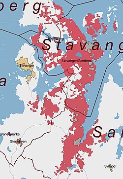
The red areas are included in Stavanger/Sandnes
Coordinates: 58°57′54″N05°43′04″E / 58.96500°N 5.71778°E / 58.96500; 5.71778 Coordinates: 58°57′54″N05°43′04″E / 58.96500°N 5.71778°E / 58.96500; 5.71778
Country Norway
Region Western Norway
County Rogaland
District Jæren
Area
[1]
  Total80.09 km2 (30.92 sq mi)
Population
 (2021) [1]
  Total229,911
  Density2,871/km2 (7,440/sq mi)
Time zone UTC+01:00 (CET)
  Summer (DST) UTC+02:00 (CEST)

Stavanger/Sandnes is the third largest urban area in Norway. It consists of the densely built-up areas in the municipalities of Stavanger, Sandnes, Sola, and Randaberg, most of which are located on the Stavanger Peninsula, its surrounding islands, and the mainland south of the peninsula. Stavanger/Sandnes is the central part of the Stavanger Region.

On 1 January 2021, the 80.09-square-kilometre (30.92 sq mi) urban area had a population of 229,911. This gives the urban area a population density of 2,871 inhabitants per square kilometre (7,440/sq mi). [1] The area has had a big growth in population, and is one of the fastest growing urban areas in Norway. It is expected that larger portions of Sola municipality will grow together with the urban area in the future.

Population

Population by municipality [2]
NamePopulation in this urban areaTotal municipal population
Stavanger129,300132,102
Sandnes58,69473,624
Sola13,84625,708
Randaberg9,03410,556

Related Research Articles

<span class="mw-page-title-main">Rogaland</span> County of Norway

Rogaland is a county in Western Norway, bordering the North Sea to the west and the counties of Vestland to the north, Vestfold og Telemark to the east and Agder to the east and southeast. In 2020, it had a population of 479,892. The administrative centre of the county is the city of Stavanger, which is one of the largest cities in Norway.

<span class="mw-page-title-main">Stavanger</span> City in Rogaland, Norway

Stavanger is a city and municipality in Norway. It is the fourth largest city and third largest metropolitan area in Norway and the administrative center of Rogaland county. The municipality is the fourth most populous in Norway. Located on the Stavanger Peninsula in southwest Norway, Stavanger counts its official founding year as 1125, the year the Stavanger Cathedral was completed. Stavanger's core is to a large degree 18th- and 19th-century wooden houses that are protected and considered part of the city's cultural heritage. This has caused the town center and inner city to retain a small-town character with an unusually high ratio of detached houses, and has contributed significantly to spreading the city's population growth to outlying parts of Greater Stavanger.

<span class="mw-page-title-main">Sandnes</span> Municipality in Rogaland County, Norway

Sandnes is a city and municipality in Rogaland, Norway. It lies immediately south of Stavanger, the 4th largest city in Norway and together, the Stavanger/Sandnes area is the third-largest urban area in Norway. The urban city of Sandnes lies in the extreme western part of the vast municipality and it makes up about 5% of the total land area of the municipality.

<span class="mw-page-title-main">Sola, Norway</span> Municipality in Rogaland, Norway

Sola is a municipality and a Seaside resort in Rogaland county, Norway. It is located in the traditional district of Jæren. The administrative centre of the municipality is the village of Solakrossen. Other villages include Tananger, Hålandsmarka, Sørnes, and Stenebyen. Stavanger Airport is located in Sola, just a short distance from the large Stavanger/Sandnes metropolitan area.

<span class="mw-page-title-main">Randaberg</span> Municipality in Rogaland, Norway

Randaberg is a municipality in Rogaland county, Norway. It is located in the traditional district of Jæren, at the northern end of the Stavanger Peninsula. The administrative centre of the municipality is the village of Randaberg.

<span class="mw-page-title-main">Meland</span> Former municipality in Hordaland, Norway

Meland is a former municipality in the Nordhordland district in the old Hordaland county, Norway. The municipality existed from 1923 until its dissolution on 1 January 2020 when it was merged into the new Alver Municipality in Vestland county. The municipality was located about 30 minutes north of the city of Bergen in Western Norway. The island municipality was mostly located on the island of Holsnøy, where the administrative centre of Frekhaug is located. Other villages in Meland include Hjartås, Holme, Io, Krossneset, Meland, and Rossland.

<span class="mw-page-title-main">Kleppe</span> Village in Western Norway, Norway

Kleppe is the administrative centre of Klepp municipality in Rogaland county, Norway. The village is located about halfway between the lakes Orrevatnet and Frøylandsvatnet. The village of Bore lies about 3 kilometres (1.9 mi) northwest of Kleppe and the village of Klepp stasjon lies about 3 kilometres (1.9 mi) to the east. The town of Bryne lies about 5 kilometres (3.1 mi) to the south and the city of Sandnes is located about 12 kilometres (7.5 mi) to the northeast. Klepp Church is located in Kleppe.

<span class="mw-page-title-main">Bryne</span> Town in Western Norway, Norway

Bryne is a town in Time municipality in Rogaland county, Norway. The city is the administrative centre of the municipality of Time and it is also one of the 50 largest towns/cities in Norway. Bryne's location in the region of Stavanger/Sandnes and its road and rail links have made Bryne a popular area for commuters. The city is expanding rapidly and there have been reports of problems with schooling capacity. Bryne Church is located in the centre of the city and Time Church is located 1 kilometre (0.62 mi) east of the city.

<span class="mw-page-title-main">Jæren</span> District in Rogaland, Norway

Jæren is a traditional district in Rogaland county, Norway. The other districts in Rogaland are Dalane, Ryfylke, and Haugalandet. Jæren is one of the 15 districts that comprise Western Norway.

<span class="mw-page-title-main">Varhaug</span> Village in Western Norway, Norway

Varhaug is the administrative centre of Hå municipality in Rogaland county, Norway. The village is located in the district of Jæren and it is the second largest village in Hå municipality after Nærbø. It was also the administrative centre for the former municipality of Varhaug from 1894 until its dissolution in 1964.

<span class="mw-page-title-main">Ålgård</span> Village in Western Norway, Norway

Ålgård is the administrative centre of Gjesdal municipality in Rogaland county, Norway. The village is located along the European route E39 highway, about 10 kilometres (6.2 mi) southeast of the city of Sandnes in the Jæren district of the county. The village includes the neighborhoods of Ålgård, Bærland, Fiskebekk, Opstad and Solås. The large lake Edlandsvatnet lies on the south side of the village, emptying into the river Figgjoelva which runs northwest to Sandnes.

<span class="mw-page-title-main">Tananger</span> Village in Western Norway, Norway

Tananger is a large village and urban area in Sola municipality in Rogaland county, Norway. The urban area is located on the west side of the Stavanger Peninsula between the North Sea and the Hafrsfjorden. It lies about 10 kilometres (6.2 mi) southwest of the city centre of Stavanger. Tananger Chapel and Tananger Church are both located here.

Hålandsmarka is a village in Sola municipality in Rogaland county, Norway. The village is located in the southwestern part of the municipality, about 1 kilometre (0.62 mi) west of the village of Stenebyen. Hålandsmarka is known for a great seaside view of most of the Rogaland coastline, on good days you will be able to see areas as far as 70 kilometres (43 mi) away.

<span class="mw-page-title-main">Hetland</span> Former municipality in Rogaland, Norway

Hetland is a former municipality in Rogaland county, Norway. The municipality existed from 1838 until 1965 when it was dissolved. The municipality included the Stavanger Peninsula and the land surrounding both sides of the Gandsfjorden, but not the area around the head of the fjord. It originally encompassed the land surrounding the city of Stavanger in the present-day municipalities of Randaberg and Stavanger and part of the municipality of Sandnes. The main church for Hetland was Hetland Church. Upon its dissolution in 1965, the 92-square-kilometre (36 sq mi) municipality had 24,173 residents.

Vatne is a village in Sandnes municipality in Rogaland county, Norway. The village lies in the borough of Hana, just about 3 kilometres (1.9 mi) northeast of the centre of the city of Sandnes. The Vatneleiren military base is located in Vatne.

<span class="mw-page-title-main">Høle</span> Borough in Western Norway, Norway

Høle is a previous borough and a village in the eastern part of Sandnes municipality in Rogaland county, Norway, located along the Høgsfjorden. The area was historically a part of the municipality of Høle. Høle Church and Høle School are both located in the village.

<span class="mw-page-title-main">Hommersåk</span> Village in Western Norway, Norway

Hommersåk is a village in Sandnes municipality in Rogaland county, Norway. The village is located in the borough of Riska in the northern part of the municipality. It is situated about 12 kilometres (7.5 mi) northeast of the centre of the city of Sandnes, along the shore of the Riskafjorden, an arm off the main Gandsfjorden. The 2.28-square-kilometre (560-acre) village has a population (2019) of 6,425 and a population density of 2,818 inhabitants per square kilometre (7,300/sq mi).

<span class="mw-page-title-main">Hinna</span> Borough in Western Norway, Norway

Hinna is a borough of the city of Stavanger which lies in the southwestern part of the large municipality of Stavanger in Rogaland county, Norway. The borough includes the southernmost part of the city, bordering the city of Sandnes. The borough of Hillevåg lies to the north, the municipality of Sola lies to the west, and the Gandsfjorden lies to the east. Hillevåg was a part of the old municipality of Hetland until 1965. The borough has residential areas as well as some industrial areas, especially relating to the oil industry. The 15-square-kilometre (3,700-acre) borough has a population (2016) of 22,581. This gives the borough a population density of 1,505 inhabitants per square kilometre (3,900/sq mi).

<span class="mw-page-title-main">Forus</span> Industrial district of Stavanger, Norway

Forus is an industrial district in the city of Stavanger which lies in the southwestern part of the large municipality of Stavanger in Rogaland county, Norway. It is located in the borough of Hinna, along the Gandsfjorden and it stretches south and west to the municipalities of Sandnes and Sola. The name Forus originates from an old farm located in this area, part of which is currently used for harness racing.

<span class="mw-page-title-main">Solakrossen</span> Village in Western Norway, Norway

Solakrossen or Sola is the administrative center of Sola municipality in Rogaland county, Norway. The village is located at the south end of the Hafrsfjorden on the Stavanger Peninsula, just northwest of the city of Sandnes. The large Stavanger Airport, Sola is located on the west side of the village. The village of Sørnes lies just to the north. Sola Church lies on the far western edge of Solakrossen. The population of Solakrossen is about 10,000, but the population is not separately tracked since it is part of the Stavanger/Sandnes urban area. The newspaper Solabladet has been published in Solakrossen since 1991.

References

  1. 1 2 3 "04859: Area and population of urban settlements (US) 2000 - 2021". Statistics Norway. 1 January 2021. Retrieved 19 April 2022.{{cite web}}: CS1 maint: url-status (link)
  2. "Urban settlements. Population and area, by municipality". Statistics Norway. 1 January 2015. Retrieved 19 April 2022.