The Rock River is a tributary of the Mississippi River, approximately 299 miles (481 km) long, in the U.S. states of Wisconsin and Illinois. The river was known as the Sinnissippi to Sauk and Fox Indians; the name means "rocky waters".

Lake Wisconsin is a reservoir on the Wisconsin River in southern Wisconsin in the United States. It is located in Columbia and Sauk counties, approximately 5 mi (8 km) southeast of Baraboo and 25 mi (40 km) NNW of Madison. Today it is home to the Wisconsin wine appellation of the Lake Wisconsin AVA.

Rock Island State Park is a state park of the state of Wisconsin, in the United States, located on Rock Island in Lake Michigan off the tip of the Door Peninsula. The only public transportation to the island is by the passenger ferry Karfi from Washington Island. However, there is mooring and dock space for people with their own boats, and during winter the island is accessible via snowmobile and foot traffic. No "wheeled vehicles" are allowed to be brought onto the island by visitors, although park staff use them routinely.

Lake Menomin is a reservoir on the Red Cedar River, in Dunn County, Wisconsin, USA.
The Enbridge Pipeline System is an oil pipeline system which transports crude oil and dilbit from Canada to the United States. The system exceeds 5,000 kilometres (3,100 mi) in length including multiple paths. More than 3,000 kilometres (1,900 mi) of the system is in the United States while the rest is in Canada and serves the Athabasca oil sands production facilities. Main parts of the system are 2,306-kilometre-long (1,433 mi) Canadian Mainline and 3,057-kilometre-long (1,900 mi) Lakehead System. On average, it delivers 1.4 million barrels per day of crude oil and other products to the major oil refineries in the American Midwest and the Canadian province of Ontario. The Canadian portion is owned by Enbridge, while the U.S. portion is partly owned by that company through Enbridge Energy Partners, LP, formerly known as Lakehead Pipe Line Partners and Lakehead Pipe Line Company.

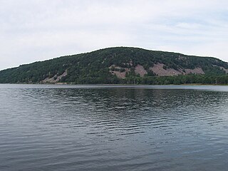
Devil's Lake is an endorheic lake in the South Range of the Baraboo Range, about two miles south of Baraboo, Wisconsin, in Sauk County, Wisconsin, USA. The lake is one of the primary attractions of Devil's Lake State Park. It is also a popular recreation destination for watercraft, fishing, hiking, and climbing.

Lake Poygan, located in the U.S. state of Wisconsin near the village of Winneconne, is an expansive widening of the Wolf River totaling over 14,000 acres (57 km²). Lake Poygan is part of the Winnebago Pool or Wolf Chain, a series of interconnected lakes fed by both the Fox and Wolf rivers. The eastern third of the lake is often referred to as Lake Winneconne. In the Menominee language it is called Pawāhekaneh, "Wild Rice Threshing Lake", referring to the traditional importance of wild rice cultivation to the local economy.

The Wisconsin Department of Natural Resources (WDNR) is an agency of the state of Wisconsin charged with conserving and managing Wisconsin's natural resources. The Wisconsin Natural Resources Board has the authority to set policy for the WDNR. The WDNR is led by the Secretary, who is appointed by the Governor of Wisconsin. The WDNR develops regulations and guidance in accordance with laws passed by the Wisconsin Legislature. It administers wildlife, fish, forests, endangered resources, air, water, waste, and other issues related to natural resources. The central office of the WDNR is located in downtown Madison, near the state capitol.

Rock Island is a wooded island off the tip of Wisconsin's Door Peninsula at the mouth of Green Bay, in Door County, Wisconsin. The 974.87-acre (394.5 ha) uninhabited island is almost entirely owned by the Wisconsin Department of Natural Resources, which maintains Rock Island State Park. It is the northernmost part of the town of Washington.

Wyalusing State Park is a 2,628-acre (1,064 ha) Wisconsin state park at the confluence of the Mississippi and Wisconsin rivers in the town of Wyalusing, just south of Prairie du Chien.
Wyalusing means "home of the warrior" in the Lenape language spoken by Munsee-Delaware tribes who settled in the area in the 19th century after being displaced from farther east. 500-foot-high (150 m) bluffs dotted with prehistoric Native American mounds look out over the river valleys. Two park resources have been recognized nationally: the Wyalusing Hardwood Forest is a National Natural Landmark and the Wyalusing State Park Mounds Archaeological District is on the National Register of Historic Places.

Newport State Park is a 2,373-acre (960 ha) Wisconsin state park at the tip of Door Peninsula near Ellison Bay, Wisconsin. Protecting 11 miles (18 km) of shoreline on Lake Michigan, Newport is Wisconsin's only wilderness-designated state park. In 2017, the International Dark-Sky Association named Newport a Dark-sky preserve. The park is open year-round and can be accessed via Wisconsin state highway 42.

Buena Vista Marsh is a state wildlife area in Portage County, Wisconsin, United States.
The Platte River is a tributary of the Mississippi River in southwestern Wisconsin in the United States. Its watershed lies almost entirely within Grant County, with only a small portion in neighboring Iowa County, and its main tributary is the Little Platte River. It is about 47 mi (76 km) long.

Tom Doyle Lake is a lake located in Newbold, within Oneida County, Wisconsin. The lake is 108 acres in size with a maximum depth of 30 feet.
Holcombe Flowage is a reservoir on the Chippewa River in Chippewa County and Rusk County, Wisconsin. The dam stands between the towns of Birch Creek and Lake Holcombe, just west of the settlement of Holcombe, Wisconsin, in Chippewa County, where most of the reservoir lies. A small part of the reservoir also extends northward into the Town of Willard in Rusk County.

Lake Altoona, is a man-made lake in Eau Claire County, Wisconsin, United States, bordering the city of Altoona, Wisconsin, and to the east of Eau Claire.

Fourmile Island Rookery is a Wisconsin Department of Natural Resources-designated State Natural Area located within Horicon State Wildlife Area. It features a narrow, forested 15-acre island that serves as one of the largest heron and gull rookeries in the Midwest.
Crystal Lake is one of at least 22 lakes of that name in the state of Wisconsin. It has a surface area of about 93 acres, and is located just south of Big Muskellunge Lake, in Vilas County in the Northern Highland region of Wisconsin. The nearest community is Sayner, about 5 miles to the east. Visitors have access to the lake from a public boat landing, public beaches and the Northern Highland-American Legion State Forest. Fish include panfish, largemouth bass, and trout.

The Southern Unit of the Kettle Moraine State Forest includes more than 22,000 acres of land throughout southern Wisconsin and spans several state parks and natural areas. The area also features varied environments from restored prairie, forests, and lakes, along with providing a multitude of recreational opportunities such as hiking, birdwatching, fishing, camping, and hunting. The Kettle Moraine Scenic Drive also extends within this region as well as through a larger portion of the state.

The Gandy Dancer State Trail is a 98 mile recreational trail spanning through Wisconsin and Minnesota. The trail is managed by Polk, Burnett, and Douglas County in Wisconsin and the Minnesota Department of Natural Resources in Minnesota.


