
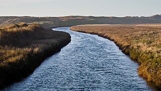
The Santa Clara River is 83 mi (134 km) long, and is one of the most dynamic river systems in Southern California. The river drains parts of four ranges in the Transverse Ranges System north and northwest of Los Angeles, then flows west onto the Oxnard Plain and into the Santa Barbara Channel of the Pacific Ocean.

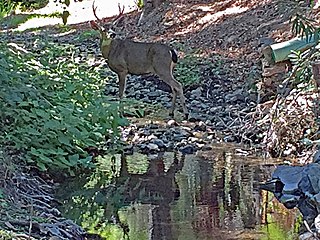
The rainbow trout is a trout and species of salmonid native to cold-water tributaries of the Pacific Ocean in Asia and North America. The steelhead is an anadromous (sea-run) form of the coastal rainbow trout(O. m. irideus) or Columbia River redband trout (O. m. gairdneri) that usually returns to fresh water to spawn after living two to three years in the ocean. Freshwater forms that have been introduced into the Great Lakes and migrate into tributaries to spawn are also called steelhead.

→

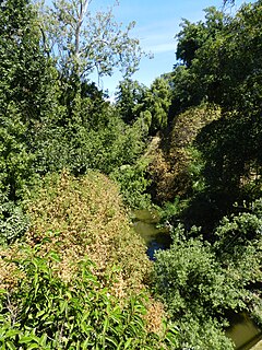
Stevens Creek is a creek in Santa Clara County, California. The creek originates in the Santa Cruz Mountains on the western flank of Black Mountain in the Monte Bello Open Space Preserve near the terminus of Page Mill Road at Skyline Boulevard. It flows southeasterly through the Stevens Creek County Park before turning northeast into Stevens Creek Reservoir. It then continues north for 12.5 miles through Cupertino, Los Altos, Sunnyvale and Mountain View before emptying into the San Francisco Bay at the Whisman Slough, near Google's main campus.

Jedediah Smith Redwoods State Park is a state park of California, United States, preserving old-growth redwoods along the Smith River. It is located along U.S. Route 199 approximately 9 miles (14 km) east of Crescent City. The park is named after explorer Jedediah Smith, and is one of four parks cooperatively managed as Redwood National and State Parks. The 10,430-acre (4,220 ha) park was established in 1939 and designated part of the California Coast Ranges International Biosphere Reserve in 1983.

Malibu Creek is a year-round stream in western Los Angeles County, California. It drains the southern Conejo Valley and Simi Hills, flowing south through the Santa Monica Mountains, and enters Santa Monica Bay in Malibu, California. The Malibu Creek watershed drains 109 square miles (280 km2) and its tributary creeks reach as high as 3,000 feet (910 m) into Ventura County, California. The creek's mainstem begins south of Westlake Village at the confluence of Triunfo Creek and Lobo Canyon Creek, and flows 13.4 miles (21.6 km) to Malibu Lagoon.

Alameda Creek is a large perennial stream in the San Francisco Bay Area. The creek runs for 45 miles (72 km) from a lake northeast of Packard Ridge to the eastern shore of San Francisco Bay by way of Niles Canyon and a flood control channel. Along its course, Alameda Creek provides wildlife habitat, water supply, a conduit for flood waters, opportunities for recreation, and a host of aesthetic and environmental values. The creek and three major reservoirs in the watershed are used as water supply by the San Francisco Public Utilities Commission, Alameda County Water District and Zone 7 Water Agency. Within the watershed can be found the highest peaks and tallest waterfall in the East Bay, over a dozen regional parks, and notable natural landmarks such as the cascades at Little Yosemite and the wildflower-strewn grasslands and oak savannahs of Sunol Preserve. After an absence of half a century, ocean-run steelhead trout will soon be able to return to Alameda Creek to mingle with remnant rainbow trout populations. Completion of a series of dam removal and fish passage projects, along with improved stream flows for cold-water fish and planned habitat restoration, will improve and restore habitat conditions for migratory fish. Steelhead trout and chinook salmon will soon be able to access up to twenty miles of spawning and rearing habitat in Alameda Creek and its tributaries. http://alamedacreek.org/learn-more/overview-watershed.php

The Los Gatos Creek runs 24 miles (39 km) in California through Santa Clara Valley Water District's Guadalupe Watershed from the Santa Cruz Mountains northward through the Santa Clara Valley until its confluence with the Guadalupe River in downtown San Jose. The Guadalupe River then continues onward into San Francisco Bay.

San Francisquito Creek is a creek that flows into southwest San Francisco Bay in California, United States. Historically it was called the Arroyo de San Francisco by Juan Bautista de Anza in 1776. San Francisquito Creek courses through the towns of Portola Valley and Woodside, as well as the cities of Menlo Park, Palo Alto, and East Palo Alto. The creek and its Los Trancos Creek tributary define the boundary between San Mateo and Santa Clara counties.

San Leandro Creek is a 21.7-mile-long (34.9 km) year-round natural stream in the hills above Oakland in Alameda County and Contra Costa County of the East Bay in northern California.

Arroyo Corte Madera del Presidio is a 4.1-mile-long (6.6 km) year-round stream in southern Marin County, California, United States. This watercourse is also known as Corte Madera Creek, although the actual stream of that name flows into San Francisco Bay further north at Point San Quentin. This watercourse has a catchment basin of about 8 square miles (21 km2) and drains the south-eastern slopes of Mount Tamalpais and much of the area in and around the town of Mill Valley; this stream discharges to Richardson Bay.

Wildcat Creek is a 13.4-mile-long (21.6 km) creek which flows through Wildcat Canyon situated between the Berkeley Hills and the San Pablo Ridge, emptying into San Pablo Bay in Contra Costa County, northern California.

Pinole Creek is a stream in western Contra Costa County, in the East Bay region of the San Francisco Bay Area, California.
Pescadero Creek is a major stream in Santa Cruz and San Mateo counties in California, United States. At 26.6 miles (42.8 km), it is the longest stream in San Mateo County and flows all year from springs in the Santa Cruz Mountains. Its source is at 1,880 feet (570 m) above sea level on the western edge of Castle Rock State Park, with additional headwaters in Portola Redwoods State Park, and its course traverses Pescadero Creek County Park and San Mateo County Memorial Park before entering Pescadero Marsh Natural Preserve at Pescadero State Beach and thence to the Pacific Ocean 14.4 miles (23 km) south of Half Moon Bay.

Uvas Creek is a 29.5-mile-long (47.5 km) mainly southward-flowing stream originating on Loma Prieta peak of the Santa Cruz Mountains, in Santa Clara County, California, United States. The creek descends through Uvas Canyon County Park into Uvas Reservoir near Morgan Hill, and on through Uvas Creek Preserve and Christmas Hill Park in Gilroy. Upon passing U.S. Highway 101 it is known as Carnadero Creek, shortly before the confluence with the Pajaro River at the Santa Clara County - San Benito County boundary.
Permanente Creek is a 13.3-mile-long (21.4 km) stream originating on Black Mountain in Santa Clara County, California, United States. It is the namesake for the Kaiser Permanente health maintenance organization. Named by early Spanish explorers as Arroyo Permanente or Rio Permanente because of its perennial flow, the creek descends the east flank of Black Mountain then courses north through Los Altos and Mountain View culminating in southwest San Francisco Bay historically at the Mountain View Slough but now partly diverted via the Permanente Creek Diversion Channel to Stevens Creek and the Whisman Slough in San Francisco Bay.

Marsh Creek is a stream in east Contra Costa County, California in Northern California which rises on the eastern side of Mount Diablo and flows 30 miles (48 km) to the Sacramento–San Joaquin River Delta at Oakley, California, near Big Break Regional Shoreline. The creek flows through Marsh Creek State Park (California), where water is impounded to form Marsh Creek Reservoir, then through the city of Brentwood, California.
San Lorenzo Creek is a 10.7-mile-long (17.2 km) year-round natural stream flowing through Hayward, California and other neighboring unincorporated communities into San Francisco Bay at the Hayward Regional Shoreline.
Cordilleras Creek is a 3.8-mile-long (6.1 km) northward-flowing stream originating in the Pulgas Ridge Open Space Preserve in the foothills of the Santa Cruz Mountains. It forms the border between San Carlos and Redwood City in San Mateo County, California, United States before entering Smith Slough where its waters course to Steinberger Slough and thence to San Francisco Bay.

North Fork Pacheco Creek is a 19 miles (31 km) tributary stream of Pacheco Creek, in Santa Clara County, California. Originally it was considered the upper reach of Pacheco Creek. Its source is at an elevation of 2,360 feet (720 m) at 37°11′17″N121°25′42″W on a mountain side in Henry W. Coe State Park and is the headwaters of the Pajaro River watershed.