Steenderen

Last updated
Steenderen
Steenderen, dorpszicht met kerk1+2 foto7 2012-04-20 18.02.jpg
Steenderen, view to the village with two church towers
Steenderen vlag.svg
Steenderen wapen.svg
2010-NL-P05-Gelderland-positiekaart-gemnamen.jpg
Red pog.svg
Steenderen
Location in the province of Gelderland
Netherlands location map.svg
Red pog.svg
Steenderen
Steenderen (Netherlands)
Coordinates: 52°3′52″N6°11′12″E / 52.06444°N 6.18667°E / 52.06444; 6.18667
Country Netherlands
Province Gelderland
Municipality Bronckhorst
Area
[1]
  Total50.21 km2 (19.39 sq mi)
Elevation
[2]
10 m (30 ft)
Population
 (2021) [1]
  Total4,655
  Density93/km2 (240/sq mi)
Time zone UTC+1 (CET)
  Summer (DST) UTC+2 (CEST)
Postal code
7221-7229 [1]
Dialing code 0575

Steenderen is a former municipality and a village in the eastern Netherlands. It has been part of the new municipality of Bronckhorst since 2005. [3]

Contents

History

It was first mentioned in 1046 as Stenere, and means "stone buildings on a sandy ridge". [4] In 1217, a parish church is established. The Dutch Reformed Church has elements dating from the 14th century. In 1782, it suffered a fire after a lightning strike, and was rebuilt. The church was restored between 1966 and 1972. [5] In 1840, it was home to 486 people. [3]

The grist mill Bronkhorstermolen dates from 1844 and was restored in 1960. [5] The potato and chips factory Aviko was founded in Steenderen in 1962. In 2019, a 35 metres (115 ft) refrigerator tower was constructed, giving Steenderen three towers. [3]

Former population centres

Related Research Articles

<span class="mw-page-title-main">Ruurlo</span> Village in Gelderland, Netherlands

Ruurlo is a village and former municipality in the province of Gelderland in the eastern part of the Netherlands.

<span class="mw-page-title-main">Vorden</span> Former municipality and village in Gelderland, Netherlands

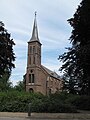
Vorden is a former municipality and a town in the eastern Netherlands, about 10 kilometres south-east of Zutphen. On 1 January 2005 the municipality merged with Hummelo en Keppel, Steenderen, Hengelo en Zelhem, to form the new municipality Bronckhorst.

<span class="mw-page-title-main">Oirschot</span> Municipality in North Brabant, Netherlands

Oirschot is a municipality and a town in the southern Netherlands. It is situated 12 kilometres (7.5 mi) from the city of Eindhoven and 20 kilometres (12 mi) from the city of Tilburg in the province North Brabant (Noord-Brabant). The municipality had a population of 18,842 in 2021.

<span class="mw-page-title-main">Sint-Oedenrode</span> Town in North Brabant, Netherlands

Sint-Oedenrode is a town in the province of North Brabant.

<span class="mw-page-title-main">Bronkhorst</span> Small city in Gelderland, Netherlands

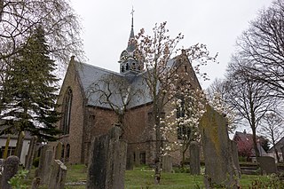
Bronkhorst is a village in the municipality of Bronckhorst, Gelderland, the Netherlands. Technically, it is a city and with only 157 inhabitants (2010), it is one of the smallest cities in the Netherlands.

<span class="mw-page-title-main">Bronckhorst</span> Municipality in Gelderland, Netherlands

Bronckhorst is a municipality in Gelderland, the Netherlands. The municipality is the result of a merger of the former municipalities Hengelo, Hummelo en Keppel, Steenderen, Vorden and Zelhem, on 1 January 2005. The municipality is named after the medieval castle of the Bronckhorst family, who once ruled this area.

<span class="mw-page-title-main">Sint Maartensbrug</span> Village in North Holland, Netherlands

Sint Maartensbrug is a village in the Dutch province of North Holland. It is a part of the municipality of Schagen, and lies about 14 km northwest of Heerhugowaard.

<span class="mw-page-title-main">Sint-Annaland</span> Village in Zeeland, Netherlands

Sint-Annaland is a village in the Dutch province of Zeeland. It is a part of the municipality of Tholen, and lies about 18 km northwest of Bergen op Zoom.

<span class="mw-page-title-main">Clinge</span> Village in Zeeland, Netherlands

Clinge is a village in the Dutch province of Zeeland. It is a part of the municipality of Hulst, and lies about 28 km southwest of Bergen op Zoom. Clinge is located on the Dutch-Belgian border and joins with the Belgian town of De Klinge, in the Belgian municipality of Sint-Gillis-Waas. This border can normally be crossed freely.

<span class="mw-page-title-main">Dreumel</span> Village in Gelderland, Netherlands

Dreumel is a village in the Dutch province of Gelderland. It is a part of the municipality of West Maas en Waal, and lies about 4 km south of Tiel.

<span class="mw-page-title-main">Sint Pancras</span> Village in North Holland, Netherlands

Sint Pancras is a town in the northwestern Netherlands. It is located in the municipality of Dijk en Waard, North Holland, about 5 km northeast of Alkmaar.

<span class="mw-page-title-main">Roggel</span> Village in Limburg, Netherlands

Roggel is a village in the Dutch province of Limburg. It is located in the municipality of Leudal.

<span class="mw-page-title-main">Sint Geertruid</span> Village in Limburg, Netherlands

Sint Geertruid is a village in the Dutch province of Limburg. It is located the municipality of Eijsden-Margraten.

<span class="mw-page-title-main">Halsteren</span> Town in North Brabant, Netherlands

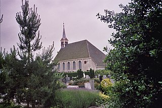
Halsteren is a town in the Dutch province of North Brabant. It is located in the municipality of Bergen op Zoom, about 1 km north of that city. Halsteren has an old church from the 14th century and a new church, built in 1919. A little village called Polder was located between Halsteren and Tholen in the Middle Ages.

<span class="mw-page-title-main">Moergestel</span> Village in North Brabant, Netherlands

Moergestel is a village in the Dutch province of North Brabant. It is located in the municipality of Oisterwijk, about 7 km East of Tilburg.

<span class="mw-page-title-main">Sint Anthoniepolder</span> Hamlet in South Holland, Netherlands

Sint Anthoniepolder is a hamlet in the Dutch province of South Holland. It is located about 14 km south of the city of Rotterdam, in the municipality of Hoeksche Waard.

<span class="mw-page-title-main">Sintjohannesga</span> Village in Friesland, Netherlands

Sintjohannesga is a village in De Fryske Marren municipality in the province of Friesland, the Netherlands. It had a population of around 1280 in 2017.

<span class="mw-page-title-main">Astene</span> Village in East Flanders, Belgium

Astene is a village and deelgemeente (sub-municipality) in the municipality of Deinze in the Belgian province of East Flanders. The village is located along the Leie River and about 13 kilometres (8.1 mi) south-west of Ghent.

<span class="mw-page-title-main">Ooij, Berg en Dal</span> Village in Gelderland, Netherlands

Ooij is a village in the eastern Netherlands. It is located in the municipality of Berg en Dal, Gelderland.

<span class="mw-page-title-main">Sint Jansklooster</span> Village in Overijssel, Netherlands

Sint Jansklooster is a village in the municipality Steenwijkerland of the Dutch province of Overijssel. It started as a monastery. The village is located near the Weerribben-Wieden National Park, and organises an annual bloemencorso.

References

  1. 1 2 3 "Kerncijfers wijken en buurten 2021". Central Bureau of Statistics. Retrieved 20 March 2022.
  2. "Postcodetool for 7221AA". Actueel Hoogtebestand Nederland (in Dutch). Het Waterschapshuis. Retrieved 20 March 2022.
  3. 1 2 3 "Steenderen". Plaatsengids (in Dutch). Retrieved 20 March 2022.
  4. "Steenderen - (geografische naam)". Etymologiebank (in Dutch). Retrieved 20 March 2022.
  5. 1 2 Ronald Stenvert & Sabine Broekhoven (2000). "Steenderen" (in Dutch). Zwolle: Waanders. p. 293. ISBN   90 400 9406 3 . Retrieved 20 March 2022.