
Northville is a village in the northern part of the town of Northampton in Fulton County, New York, United States, northeast of Gloversville. The population was 993 at the 2020 census. It lies within Adirondack Park and serves as the southern terminus for the Northville-Placid Trail.

Edinburg is a town in northwestern Saratoga County, New York, United States. It is located in the Adirondack Park. The Batchellerville Bridge crosses Great Sacandaga Lake, connecting parts of the town on either shore.

Hadley is a town in Saratoga County, New York, United States. The population was 1,971 at the 2000 census. The town was named after Hadley, Massachusetts.

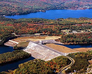
The Great Sacandaga Lake is a large lake situated in the Adirondack Park in northern New York in the United States. The lake has a surface area of about 41.7 square miles (108 km2) at capacity, and the length is about 29 miles (47 km). The word Sacandaga means "Land of the Waving Grass" in the native Mohawk language. The lake is located in the northern parts of Fulton County and Saratoga County near the southern border of the Adirondack Park. A small portion also extends northward into southern Hamilton County. The broader, south end of the lake is northeast of the City of Johnstown and the City of Gloversville. Great Sacandaga Lake is a reservoir created by damming the Sacandaga River. The primary purpose for the creation of the reservoir was to control flooding on the Hudson River and the Sacandaga River, floods which had a historically significant impact on the surrounding communities.

The Sacandaga River is a 64-mile-long (103 km) river in the northern part of New York in the United States. Its name comes from the Native American Sa-chen-da'-ga, meaning "overflowed lands".

The Bhima River is a major river in Western and South India. It flows southeast for 861 kilometres (535 mi) through Maharashtra, Karnataka, and Telangana states, before joining the Krishna River. After the first sixty-five kilometers in a narrow valley through rugged terrain, the banks open up and form a fertile agricultural area which is densely populated.

The Croton River is a river in southern New York with three principal tributaries: the West Branch, Middle Branch, and East Branch. Their waters, all part of the New York City water supply system, join downstream from the Croton Falls Reservoir. Together, their waters and the reservoirs linked to them represent the northern half of the New York City water system's Croton Watershed.

The Conklingville Dam, in Hadley, Saratoga County, New York, is an earthen dam which holds back the Great Sacandaga Lake.
The Rocky River is very short and small tributary of the Housatonic River in the U.S. state of Connecticut. It flows into the Housatonic River from the west just upstream from New Milford at 41°35′00″N73°26′23″W

The Mill River is a 16.3-mile (26.2 km) river in the town of Fairfield, Connecticut. It flows into Long Island Sound at Southport harbor.

Renuka Sagara, also known as Malaprabha reservoir and Navilutheertha reservoir, is a dam and impounding reservoir constructed across the Malaprabha River in the Krishna River basin. It is situated at Navilatirtha village in Savadatti Taluk Taluk of Belagavi district in North Karnataka, India. The dam is 43.13 metres high and has 4 vertical crest gates; it impounds a large reservoir with a gross surface area of 54.97 square kilometres, and storage capacity of 37.73 thousand million cubic feet. It is an earthen and masonry dam which caters to the irrigation needs for over 1,961.30 square kilometres, and hydroelectric power generation.

The Kohanza Reservoir was a reservoir in Danbury, Connecticut. Construction was completed in 1866. It was the first of many reservoirs built to supply Danbury's hat factories. The dam broke on January 31, 1869. The ensuing flood of ice and water killed 11 people in half an hour, and caused major damage to many homes and farms, as well as uprooting trees and moving boulders.
The Stony River is a 26.7-mile-long (43.0 km) tributary of the North Branch Potomac River in Grant County in West Virginia's Eastern Panhandle. The Stony River joins with the North Branch at the Mineral County border. Its source lies north of the Dolly Sods Wilderness on the Tucker County border in the Allegheny Front. Tributaries of the Stony River include Mud Run, Red Sea Run, Morgan Run, Helmick Run, Fourmile Run, Laurel Run, and Mill Run.

The Spier Falls Dam is a hydroelectric dam on the Hudson River between the towns of Moreau and Lake Luzerne, New York.
Shadehill is an unincorporated community in Perkins County, in the U.S. state of South Dakota.
The Franklin Falls Dam is located on the Pemigewasset River in the city of Franklin, New Hampshire, in the United States. The dam was constructed between 1939 and 1943 by the Army Corps of Engineers and extends for 0.75 miles (1.21 km) across the river. During its construction, the neighboring residents of the town of Hill were forced to relocate to higher ground due to rising water levels created by the dam. The reservoir formed by the dam has a permanent pool covering 440 acres (180 ha), and the total flood storage capacity is 2,800 acres (1,100 ha). The total area of the project, including surrounding managed lands, is 3,683 acres (1,490 ha). The stretch of the Pemigewasset River potentially impounded by the dam extends 12.5 miles (20 km) north to Ayers Island Dam in the town of Bristol, and the watershed flowing to the dam extends north all the way into the White Mountains.

The Hudson River–Black River Regulating District (HRBRRD) is a New York state public-benefit corporation that traces its formation to the creation of the Black River Regulating District in 1919, and the Hudson River Regulating District in 1922 in response to the severe historical flooding of the cities of Albany, Green Island, Rensselaer, Troy, and Watervliet by the Sacandaga River and Hudson River and its tributaries. The HRBRRD, formed in 1959 by combining the two entities, collects excess runoff to reduce flooding impacts in the Hudson River and Black River basins, and releases this captured water gradually during periods of low river flow to maintain water quality in each river basin. This system was designed to reduce damage from spring storms and snowmelt, including disease and destruction of life and property, and to improve river navigation and public sanitation. The HRBRRD was also formed with hydroelectric generation in mind. It owns and operates several dams—including the Conklingville Dam which formed the Great Sacandaga Lake—and reservoirs.
The Muscoot River is a short tributary of the Croton River in Putnam and Westchester counties in the state of New York. Approximately 6 mi (9.7 km) long and running north-to-south, it lies within the Croton River watershed and is part of the New York City water supply system's Croton Watershed.