Conklingville Dam

Last updated
Conklingville Dam
Conklingville Dam.jpg
A photo of the dam from County Route 7
New York Adirondack.svg
Red pog.svg
Location of Conklingville Dam in New York Adirondack Park
CountryUnited States
Location New York
Coordinates 43°19′05″N73°55′24″W / 43.3180°N 73.9234°W / 43.3180; -73.9234 Coordinates: 43°19′05″N73°55′24″W / 43.3180°N 73.9234°W / 43.3180; -73.9234
Purpose Flood control
StatusOperational
Construction began1927
Opening dateMarch 27, 1930
Construction cost$12 million
Owner(s)Hudson River-Black River Regulating District
Dam and spillways
Type of dam Earth fill dam
Impounds Sacandaga River
Height (foundation)95 feet (29 m)
Reservoir
Creates Great Sacandaga Lake
Total capacity29,920,000,000 cubic feet (847,000,000 m3)
Catchment area 1,044 square miles (2,700 km2)
Surface area41.7 square miles (108 km2)
Maximum length20 miles (32 km)
Maximum width5 miles (8.0 km)
Installed capacity22 kilowatt-hours (79 MJ)

The Conklingville Dam, in Hadley, Saratoga County, New York, is an earthen dam which holds back the Great Sacandaga Lake (in the town of Day, New York).

Hadley, New York Town in New York, United States

Hadley is a town in Saratoga County, New York, United States. The population was 1,971 at the 2000 census. The town was named after Hadley, Massachusetts.

Saratoga County, New York County in the United States

Saratoga County is a county in the U.S. state of New York. As of the 2017 U.S. Census estimate, the county's population was 229,869, representing a 4.7% increase from the 2010 population of 219,607, representing one of the fastest growth rates in the northeastern United States and the fastest-growing county in Upstate New York. The county seat is Ballston Spa. Saratoga County is included in the Capital District, encompassing the Albany-Schenectady-Troy, New York Metropolitan Statistical Area.

Embankment dam large artificial dam

An embankment dam is a large artificial dam. It is typically created by the placement and compaction of a complex semi-plastic mound of various compositions of soil, sand, clay, or rock. It has a semi-pervious waterproof natural covering for its surface and a dense, impervious core. This makes such a dam impervious to surface or seepage erosion. Such a dam is composed of fragmented independent material particles. The friction and interaction of particles binds the particles together into a stable mass rather than by the use of a cementing substance.

Contents

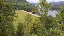
The dam, completed in 1930, is owned by the Hudson River-Black River Regulating District. It stands 95 feet high, impounds a maximum of 792,000 acre-feet; the lake has a perimeter of 129 miles (208 km), and an area of 42 square miles (11,000 ha). [1] The hydroelectric plant is named for Elmer West, a builder of the Spier Falls Dam located downstream on the Hudson. [2] [3]

Spier Falls Dam

The Spier Falls Dam is a hydroelectric dam on the Hudson River between the towns of Moreau, New York and Lake Luzerne, New York.

History

At the end of the Wisconsin Glacial Episode a glacial moraine blocked the outflow of the Sacandaga River, forming "Glacial Lake Sacandaga". The rising water eventually found an outlet over a small divide at Conklingville. The outlet gradually eroded, draining the lake. The Conklingville dam was proposed to block this outlet, and nearly restore the configuration of the glacial lake. [4]

Moraine Glacially formed accumulation of unconsolidated debris

A moraine is any glacially formed accumulation of unconsolidated glacial debris that occurs in both currently and formerly glaciated regions on Earth, through geomorphological processes. Moraines are formed from debris previously carried along by a glacier and normally consisting of somewhat rounded particles ranging in size from large boulders to minute glacial flour. Lateral moraines are formed at the side of the ice flow and terminal moraines at the foot, marking the maximum advance of the glacier. Other types of moraine include ground moraines, till-covered areas with irregular topography, and medial moraines which are formed where two glaciers meet.

The Sacandaga River was subject to periodic severe floods. A dam had been considered since the 1860s, both for flood control and, later, for power generation. In 1913 the "most disastrous [flood] in history" caused major damage to towns on the Hudson River below the Sacandaga: Albany, Green Island, Rensselaer, Troy, and Watervliet. In 1922 New York established the "Hudson River Regulating District" (now the "Hudson River-Black River Regulating District") "To regulate the flow of the Hudson and Sacandaga Rivers as required by the public welfare including health and safety." The financing was done through a combination of contributions from industries that would use the generated power (95.5%), and from the communities flooded in 1913. The dam was designed by Edward Haynes Sargent. The first bids were received in 1927. The project was projected to be completed in 1929, but various setbacks, including a flood that year, delayed completion until March 27, 1930. [2] The cost of the dam was $12 million. [2]

Sacandaga River river in the United States of America

The Sacandaga River is a 64-mile-long (103 km) river in the northern part of New York in the United States. Its name comes from the Native American Sa-chen-da'-ga, meaning "overflowed lands".

Hudson River river in New York State, draining into the Atlantic at New York City

The Hudson River is a 315-mile (507 km) river that flows from north to south primarily through eastern New York in the United States. The river originates in the Adirondack Mountains of Upstate New York, flows southward through the Hudson Valley to the Upper New York Bay between New York City and Jersey City. It eventually drains into the Atlantic Ocean at New York Harbor. The river serves as a political boundary between the states of New Jersey and New York at its southern end. Further north, it marks local boundaries between several New York counties. The lower half of the river is a tidal estuary, deeper than the body of water into which it flows, occupying the Hudson Fjord, an inlet which formed during the most recent period of North American glaciation, estimated at 26,000 to 13,300 years ago. Tidal waters influence the Hudson's flow from as far north as the city of Troy.

Albany, New York Capital of New York

Albany is the capital of the U.S. state of New York and the seat of Albany County. Albany is located on the west bank of the Hudson River approximately 10 miles (16 km) south of its confluence with the Mohawk River and approximately 135 miles (220 km) north of New York City.

Residents of the valley were bitterly opposed to the dam. In addition to lawsuits there is a story that a group of witches put a curse on the dam in an attempt to get it to fail. [5] More prosaically, the Fonda, Johnstown and Gloversville Railroad instituted a protracted lawsuit over the flooding of its tracks and finally won a judgement to $1.6 million. [6]

Fonda, Johnstown and Gloversville Railroad

The Fonda, Johnstown and Gloversville Railroad (FJ&G) was formerly a 132-mile steam engine and electric interurban railroad that connected its namesake towns in east central New York State to Schenectady, New York. It had a successful and profitable transportation business from 1870 until the 1980s carrying workers, salesmen, and executives of the very large number of glove manufacturing companies in the area to the New York Central (NYC) station at Schenectady. From here they could catch trains south to New York City (NYC) or west to Chicago. It also handled freight and had freight interchange with both the New York Central and the Delaware and Hudson railroads. Passenger business declined starting before the Great Depression and particularly during it. Following a determined and expensive effort to recapture passenger business by acquiring five ultra modern high-speed Bullet interurban cars in 1932, the FJ&G abandoned passenger service in 1938. Freight business continued on for a few more decades, was later taken over by the Delaware and Otsego Railroad management and then eventually abandoned.

Uses

The primary purpose of the dam was flood control, and the water level on the lake is still carefully regulated to prevent flooding while maintaining adequate flow downstream on the Hudson. The secondary purpose was power generation. As of 2016 the dam generates 22 Megawatts. [7] The third purpose was recreation. The Great Sacandaga Lake supports boating, fishing, swimming, and water sports. Many summer rentals of homes and boats are available.

Related Research Articles

Dartmouth Dam reservoir in Australia

Dartmouth Dam is a large rock-fill embankment dam with an uncontrolled chute spillway across the Mitta Mitta, Gibbo, and Dart rivers, the Morass Creek and a number of small tributaries. The dam is located near Mount Bogong in the north-east of the Australian state of Victoria. The dam's purpose includes irrigation, the generation of hydro-electric power, water supply and conservation. The impounded reservoir is called Dartmouth Reservoir, sometimes called Lake Dartmouth. The Dartmouth Power Station, a hydro-electric power station that generates power to the national grid, is located near the dam wall.

Dam A barrier that stops or restricts the flow of surface or underground streams

A dam is a barrier that stops or restricts the flow of water or underground streams. Reservoirs created by dams not only suppress floods but also provide water for activities such as irrigation, human consumption, industrial use, aquaculture, and navigability. Hydropower is often used in conjunction with dams to generate electricity. A dam can also be used to collect water or for storage of water which can be evenly distributed between locations. Dams generally serve the primary purpose of retaining water, while other structures such as floodgates or levees are used to manage or prevent water flow into specific land regions. The earliest known dam is the Jawa Dam in Jordan, dating to 3,000 BC.

Northville, Fulton County, New York Village in New York, United States

Northville is a village in Fulton County, New York. The population was 1,099 at the 2010 census. The village is in the northern part of the town of Northampton and is northeast of Gloversville.

Mohawk River river in New York state, United States

The Mohawk River is a 149-mile-long (240 km) river in the U.S. state of New York. It is the largest tributary of the Hudson River. The Mohawk flows into the Hudson in Cohoes, New York, a few miles north of the city of Albany. The river is named for the Mohawk Nation of the Iroquois Confederacy. It is a major waterway in north-central New York.

Spillway structure for controlled release of flows from a dam or levee

A spillway is a structure used to provide the controlled release of flows from a dam or levee into a downstream area, typically the riverbed of the dammed river itself. In the United Kingdom, they may be known as overflow channels. Spillways ensure that the water does not overflow and damage or destroy the dam.

Great Sacandaga Lake

The Great Sacandaga Lake is a large lake situated in the Adirondack Park in northern New York in the United States. The lake has a surface area of about 41.7 square miles (108 km2) at capacity, and the length is about 29 miles (47 km). The word Sacandaga means "Land of the Waving Grass" in the local native language. The lake is located in the northern parts of Fulton County and Saratoga County near the south border of the Adirondack Park. A small part of it also extends northward into southern Hamilton County. The broader, south end of the lake is northeast of the City of Johnstown and the City of Gloversville. Great Sacandaga Lake is a reservoir created by damming the Sacandaga River. The primary purpose for the creation of the reservoir was to control flooding on the Hudson River and the Sacandaga River, floods which had a historically significant impact on the surrounding communities.

Table Rock Lake reservoir on Missouri-Arkansas border

Table Rock Lake is an artificial lake or reservoir in the Ozarks of southwestern Missouri and northwestern Arkansas. The lake is impounded by Table Rock Dam constructed from 1954 to 1958 on the White River by the U.S. Army Corps of Engineers.

Dworshak Dam dam on the North Fork Clearwater River in Clearwater County, Idaho, USA

Dworshak Dam is a concrete gravity dam in the western United States, on the North Fork Clearwater River in Clearwater County, Idaho. The dam is located approximately four miles (6 km) northwest of Orofino and impounds the Dworshak Reservoir for flood control and hydroelectricity generation. With a height of 717 feet (219 m), Dworshak is the third tallest dam in the United States and the tallest straight-axis concrete dam in the Western Hemisphere. Construction of the dam by the U.S. Army Corps of Engineers (USACE) began in 1966 and was completed in 1973.

American Falls Dam architectural structure

The American Falls Dam is a concrete gravity-type dam located near the town of American Falls, Idaho, on river mile 714.7 of the Snake River. The dam and reservoir are a part of the Minidoka Project on the Snake River Plain and are used primarily for flood control, irrigation, and recreation. When the original dam was built by the Bureau of Reclamation, the residents of American Falls were forced to relocate three-quarters of their town to make room for the reservoir. A second dam was completed in 1978 and the original structure was demolished. Although the dam itself is located in Power County, its reservoir also stretches northeastward into both Bingham County and Bannock County.

Reservoir A storage space for fluids

A reservoir is, most commonly, an enlarged natural or artificial lake, pond or impoundment created using a dam or lock to store water.

Haditha Dam lake in Iraq

The Haditha Dam or Qadisiya Dam is an earth-fill dam on the Euphrates, north of Haditha (Iraq), creating Lake Qadisiyah. The dam is just over 9 kilometres (5.6 mi) long and 57 metres (187 ft) high. The purpose of the dam is to generate hydroelectricity, regulate the flow of the Euphrates and provide water for irrigation. It is the second-largest hydroelectric contributor to the power system in Iraq behind the Mosul Dam.

Douglas Dam

Douglas Dam is a hydroelectric dam on the French Broad River in Sevier County, Tennessee, in the southeastern United States. The dam is operated by the Tennessee Valley Authority (TVA), which built the dam in record time in the early 1940s to meet emergency energy demands at the height of World War II. Douglas Dam is a straight reinforced concrete gravity-type dam 1705 feet long and 202 feet high, impounding the 28,420-acre (11,500 ha) Douglas Lake. The dam was named for Douglas Bluff, a cliff overlooking the dam site prior to construction.

Run-of-the-river hydroelectricity hydro power station with no or only very small reservoir for storage

Run-of-river hydroelectricity (ROR) or run-of-the-river hydroelectricity is a type of hydroelectric generation plant whereby little or no water storage is provided. Run-of-the-river power plants may have no water storage at all or a limited amount of storage, in which case the storage reservoir is referred to as pondage. A plant without pondage is subject to seasonal river flows, thus the plant will operate as an intermittent energy source. Conventional hydro uses reservoirs, which regulate water for flood control and dispatchable electrical power.

Longyangxia Dam concrete dam on Yellow River in Qinghai, China

The Longyangxia Dam is a concrete arch-gravity dam at the entrance of the Longyangxia canyon on the Yellow River in Gonghe County, Qinghai Province, China. The dam is 178 metres (584 ft) tall and was built for the purposes of hydroelectric power generation, irrigation, ice control and flood control. The dam supports a 1,280 MW power station with 4 x 320 MW generators that can operate at a maximum capacity of 1400 MW. Controlling ice, the dam controls downstream releases to reservoirs lower in the river, allowing them to generate more power instead of mitigating ice. Water in the dam's 24.7 billion m3 reservoir provides irrigation water for up to 1,000,000 hectares of land.

Grand Ethiopian Renaissance Dam dam

The Grand Ethiopian Renaissance Dam, formerly known as the Millennium Dam and sometimes referred to as Hidase Dam, is a gravity dam on the Blue Nile River in Ethiopia that has been under construction since 2011. It is in the Benishangul-Gumuz Region of Ethiopia, about 15 km (9 mi) east of the border with Sudan. At 6.45 gigawatts, the dam will be the largest hydroelectric power plant in Africa when completed, as well as the 7th largest in the world. As of August 2017, the work stood at 60% completion. Once completed, the reservoir will take from 5 to 15 years to fill with water.

Hiyoshi Dam

Hiyoshi Dam (日吉ダム) is a dam in Nantan, Kyoto Prefecture, Japan. The dam construction started in 1992 and was completed in 1996.

Hudson River-Black River Regulating District

The Hudson River-Black River Regulating District (HRBRRD) is a New York state public-benefit corporation that was established in 1922 in response to the severe historical flooding of the cities of Albany, Green Island, Rensselaer, Troy, and Watervliet by the Sacandaga River and Hudson River and its tributaries. The HRBRRD was created to collect excess runoff to prevent flooding in the Hudson River and Black River basins, and to release this captured water gradually during periods of low river flow to maintain water quality in each river basin. This system was designed to reduce damage from spring storms and snowmelt, including disease and destruction of life and property, and to improve river navigation and public sanitation. The HRBRRD was also formed with hydroelectric generation in mind. It owns and operates several dams - including the Conklingville Dam which formed the Great Sacandaga Lake - and reservoirs.

References

  1. "Conklingville NPDP ID : NY00146 (copy at Archive.org)". National Performance of Dams Program. Archived from the original on 2016-03-06. Retrieved Sep 27, 2016.
  2. 1 2 3 "Sacandaga Reservoir". The Town of Edinburg. Retrieved Sep 27, 2016.
  3. "Upper Hudson River Watershed". Hudson River-Black River Regulating District. Retrieved Sep 27, 2016.
  4. New York State Museum Bulletin, Issues 193-196. 1917. p. 66. Retrieved Sep 29, 2016.
  5. Hall-Saladino, Samantha. "Bone Yard Gang had role in reservoir effort". Leader-Herald. Retrieved Sep 29, 2016.
  6. "Flood on the Tracks" . Retrieved Sep 29, 2016.
  7. "NY Power Plants". PowerplantJobs.com. Retrieved Sep 27, 2016.