Hughes Hall is a constituent college of the University of Cambridge in England. It is the oldest of the University of Cambridge's postgraduate colleges. The college also admits undergraduates, though undergraduates admitted by the college must be aged 21 or over. There is no age requirement for postgraduate students. The majority of Hughes Hall students are postgraduate, although nearly one-fifth of the student population comprises individuals aged 21 and above who are studying undergraduate degree courses at the university.
Cambourne is a town and civil parish in Cambridgeshire, England, in the district of South Cambridgeshire. It is a new settlement and lies on the A428 road between Cambridge, 9 miles (14 km) to the east, and St Neots and Bedford to the west. It comprises the three areas of Great Cambourne, Lower Cambourne and Upper Cambourne. The area is close to Bourn Airfield.
Woughton is a civil parish in south central Milton Keynes, Buckinghamshire, England. The parish council uses the term Community Council.
Stoneygate is part of the City of Leicester, England.

Pollokshields is an area in the Southside of Glasgow, Scotland. Its modern boundaries are largely man-made, being formed by the M77 motorway to the west and northwest with the open land of Pollok Country Park and the Dumbreck neighbourhood beyond, by the Inverclyde Line railway and other branches which separate its territory from the largely industrial areas of Kinning Park, Kingston and Port Eglinton, and by the Glasgow South Western Line running from the east to south, bordering Govanhill, Strathbungo, Crossmyloof and Shawlands residential areas. There is also a suburban railway running through the area.

The Ascension Parish Burial Ground, formerly known as the burial ground for the parish of St Giles and St Peter's, is a cemetery off Huntingdon Road in Cambridge, England. Many notable University of Cambridge academics are buried there, including three Nobel Prize winners.
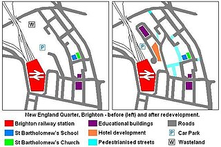
The New England Quarter is a mixed-use development in the city of Brighton and Hove, England. It was built between 2004 and 2008 on the largest brownfield site in the city, adjacent to Brighton railway station. Most parts of the scheme have been finished, but other sections are still being built and one major aspect of the original plan was refused planning permission.
Teesdale Business Park is a major business park on the former site of Head Wrightsons' Teesdale works in Thornaby-on-Tees, North Yorkshire, England. The park was redeveloped by the Teesside Development Corporation. The area is immediately north of Thornaby railway station.
Huntingdon Road is a major arterial road linking central Cambridge, England with Junction 14 of the M11 motorway and the A14 northwest from the city centre. The road, designated the A1307, follows the route of the Roman Via Devana, and is named after the town of Huntingdon, northwest of Cambridge.

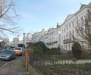
Roundhill Crescent is a late-19th-century housing development in Round Hill, an inner suburb of the English coastal city of Brighton and Hove. Partly developed in the 1860s with large terraced houses on a steeply sloping open hillside, the crescent—which "curves and changes height dramatically along its length"—was finished two decades later and now forms the centrepiece of the Round Hill conservation area. Smaller houses completed the composition in the 1880s, and England's first hospital for the treatment of mental illness was founded in the crescent in 1905. The five original sets of houses from the 1860s have been listed at Grade II by English Heritage for their architectural and historical importance, and the crescent occupies a prominent place on Brighton's skyline.

Montpelier is an inner suburban area of Brighton, part of the English city and seaside resort of Brighton and Hove. Developed together with the adjacent Clifton Hill area in the mid-19th century, it forms a high-class, architecturally cohesive residential district with "an exceptionally complete character". Stucco-clad terraced housing and villas predominate, but two of the city's most significant Victorian churches and a landmark hospital building are also in the area, which lies immediately northwest of Brighton city centre and spreads as far as the ancient parish boundary with Hove.
Montpelier Crescent is a mid 19th-century crescent of 38 houses in the Montpelier suburb of the English coastal city of Brighton and Hove. Built in five parts as a set-piece residential development in the rapidly growing seaside resort, the main part of the crescent was designed between 1843 and 1847 by prominent local architect Amon Henry Wilds and is one of his most distinctive compositions. Extra houses were added at both ends of the crescent in the mid-1850s. Unlike most other squares, terraces and crescents in Brighton, it does not face the sea—and the view it originally had towards the South Downs was blocked within a few years by a tall terrace of houses opposite. Montpelier was an exclusive and "salubrious" area of Brighton, and Montpelier Crescent has been called its "great showpiece". Wilds's central section has been protected as Grade II* listed, with the later additions listed separately at the lower Grade II. The crescent is in one of the city's 34 conservation areas, and forms one of several "outstanding examples of late Regency architecture" within it.

Vernon Terrace is a mid 19th-century residential development in the Montpelier suburb of Brighton, part of the English coastal city of Brighton and Hove. Construction of the first section started in 1856, and the 37-house terrace was complete in the early 1860s. Architecturally, the houses divide into five separate compositions, although all are in a similar late Regency/Italianate style. This was characteristic of houses of that era in Brighton, and especially in the Montpelier area—where the Regency style persisted much later than elsewhere. Standing opposite is the landmark Montpelier Crescent, which had a view of the South Downs until Vernon Terrace blocked it. Three groups of houses in the terrace have been listed at Grade II by English Heritage for their architectural and historical importance.

Adelaide Crescent is a mid-19th-century residential development in Hove, part of the English city and seaside resort of Brighton and Hove. Conceived as an ambitious attempt to rival the large, high-class Kemp Town estate east of Brighton, the crescent was not built to its original plan because time and money were insufficient. Nevertheless, together with its northerly neighbour Palmeira Square, it forms one of Hove's most important architectural set-pieces. Building work started in 1830 to the design of Decimus Burton. The adjacent land was originally occupied by "the world's largest conservatory", the Anthaeum; its collapse stopped construction of the crescent, which did not resume until the 1850s. The original design was modified and the crescent was eventually finished in the mid-1860s. Together with the Kemp Town and Brunswick Town estates, the crescent is one of the foremost pre-Victorian residential developments in the Brighton area: it has been claimed that "outside Bath, [they] have no superior in England". The buildings in the main part of Adelaide Crescent are Grade II* listed. Some of the associated buildings at the sea-facing south end are listed at the lower Grade II.
David Wyn Roberts was a British architect and educator, who designed more university buildings for Cambridge University than any other architect. With a modernist practice based in Cambridge, he also designed many city housing projects, schools, and private residences.

Livat Hammersmith, formerly known as the Kings Mall, is a retail, residential and office complex located off King Street in Hammersmith in the London Borough of Hammersmith and Fulham. Along with the other Livat Centres, it is operated by the Ingka Centres division of INGKA Holding.

The North West Cambridge Development is a University of Cambridge site to the north west of Cambridge city centre in England. The development is meant to alleviate overcrowding and rising land prices in Cambridge. The first phase resulted from a £350 million investment by the university. The development opened to the public for the Open Cambridge event on 9 September 2017.
31 Madingley Road is a Modernist red-brick house in Madingley Road, west Cambridge, England, designed by Marshall Sisson for the classical archaeologist A. W. Lawrence in 1931–32. It is one of the first Modernist-style houses in Cambridge, and is listed at grade II.

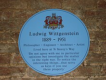
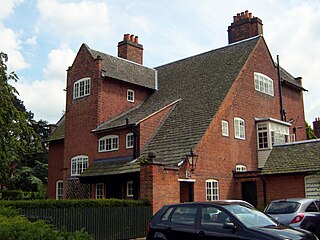
48 Storey's Way is an Arts and Crafts house in west Cambridge, England, designed by M. H. Baillie Scott for Herbert Ainslie Roberts, a university administrator, and built in 1912–13. The architectural historian Alan Powers considers it an archetype of the English Arts and Crafts movement, although it is a late example of that movement. It is listed at grade II*.

There are 833 listed buildings in the district of Cambridge, England. This list summarises the 87 in the west and north-west suburbs, in the area west of the Backs and broadly between Huntingdon Road, Queen's Road, Barton Road and the M11. This was the West Fields, which largely passed into the ownership of the Cambridge colleges, particularly St John's, after enclosure in 1805, and was little developed until after 1870; the older population centres of Castle Hill and Newnham are excluded from this list. The major roads are Madingley Road running east–west and Grange Road running north–south. There are 18 buildings listed at grade II*, with the remainder at grade II; there are no grade-I-listed buildings in this area.