
The Cavendish Laboratory is the Department of Physics at the University of Cambridge, and is part of the School of Physical Sciences. The laboratory was opened in 1874 on the New Museums Site as a laboratory for experimental physics and is named after the British chemist and physicist Henry Cavendish. The laboratory has had a huge influence on research in the disciplines of physics and biology.

Coton is a small village and civil parish about three miles west of Cambridge in Cambridgeshire, England and about the same distance east of the Prime Meridian. It is in the district of South Cambridgeshire. The parish covers an area of 392 hectares. In the 2001 census it had a population of 773, with approximately 336 dwellings and 322 households. The population at the 2011 census was 910.

Lucy Cavendish College is a constituent college of the University of Cambridge.

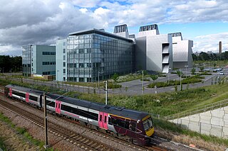
West Cambridge is a university site to the west of Cambridge city centre in England. As part of the West Cambridge Master Plan, several of the University of Cambridge's departments have relocated to the West Cambridge site from the centre of town due to overcrowding. A number of other research institutions also have buildings on the site.

The Mullard Radio Astronomy Observatory (MRAO) is located near Cambridge, UK and is home to a number of the largest and most advanced aperture synthesis radio telescopes in the world, including the One-Mile Telescope, 5-km Ryle Telescope, and the Arcminute Microkelvin Imager. It was founded by the University of Cambridge and is part of the Cambridge University, Cavendish Laboratories, Astrophysics Department.

Girton is a village and civil parish of about 1,600 households, and 4,500 people, in Cambridgeshire, England. It lies about 2 miles (3 km) to the northwest of Cambridge, and is the home of Girton College, a constituent college of the University of Cambridge.

Hills Road Sixth Form College is a public sector co-educational sixth form college in Cambridge, England, providing full-time A-level courses for approximately 2400 sixth form students from the surrounding area and a variety of courses to around 4,000 part-time students of all ages in the adult education programme, held as daytime and evening classes.
John James StevensonFRSE FSA FRIBA, usually referred to as J. J. Stevenson, was a British architect of the late-Victorian era. Born in Glasgow, he worked in Glasgow, Edinburgh and London. He is particularly associated with the British Queen Anne revival style.
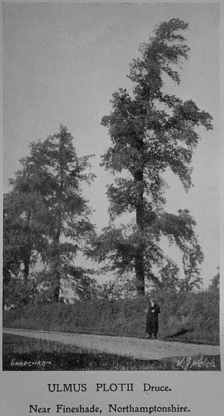
The field elm cultivar Ulmus minor 'Plotii', commonly known as Lock elm or Lock's elm, Plot's elm or Plot elm, and first classified as Ulmus sativaMill. var. Lockii and later as Ulmus plotii by Druce in 1907-11, is endemic mainly to the East Midlands of England, notably around the River Witham in Lincolnshire, in the Trent Valley around Newark-on-Trent, and around the village of Laxton, Northamptonshire. Ronald Melville suggested that the tree's distribution may be related to river valley systems, in particular those of the Trent, Witham, Welland, and Nene. Two further populations existed in Gloucestershire. It has been described as Britain's rarest native elm, and recorded by The Wildlife Trust as a nationally scarce species.
Conduit Head is a 1910 house located off the Madingley Road (A1303) on the western outskirts of Cambridge, England. Built in 1910, it was designed by Harry Redfern for Francis Darwin, and was built for Darwin's daughter Frances on the occasion of her marriage to F. M. Cornford. The architectural historians Simon Bradley and Nikolaus Pevsner describe the house as "gabled, rural and relaxed".
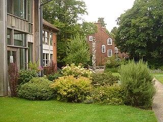
Marshall House has been the President's Lodge at Lucy Cavendish College, Cambridge, England, since 2001. It was designed by the Scottish architect J. J. Stevenson and built in 1886. It is a Grade II listed building.
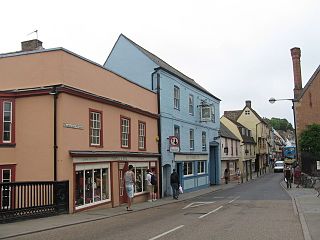
Magdalene Street is a street in the north of central Cambridge, England. It runs between Castle Street, by Castle Hill, at the junction with Northampton Street and Chesterton Lane, then Chesterton Road, to the northwest and Bridge Street at the junction with Thompson's Lane to the southeast.
Grange Road is a street in Cambridge, England. It stretches north–south, meeting Madingley Road (A1303) at a T-junction to the north and Barton Road (A603) to the south. It runs approximately parallel with the River Cam to the east. Grange Road is almost one mile long and has 17th-century origins. It contains several colleges of the University of Cambridge.

Northampton Street is a street in the north of central Cambridge, England. It runs between Madingley Road and Queen's Road to the west and Castle Street, by Castle Hill, Chesterton Lane, and Magdalene Street to the east.

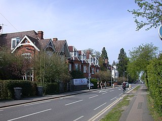
Victoria Road is a residential road in the north of Cambridge, England. The road is designated the A1134. At the western end, the road links with Histon Road, Huntingdon Road, Mount Pleasant, and Castle Street.In 1950, there were plans to improve this junction, but they never came to fruition. At the eastern end it links with Chesterton Road (A1303) and also links to Milton Road, the A1134, then A1309, northeast out of the city, also linking with the A14.
Cambridge is a university town and the administrative centre of the county of Cambridgeshire, England. It lies in East Anglia about 50 miles (80 km) north of London. Its main transport links are the M11 road to London, the A14 east–west road and the West Anglia Main Line railway to London.

The following is a timeline of the history of the city of Cambridge, England.

Wilberforce Road is a street in the western outskirts of Cambridge, England, which runs north–south for 550 metres, connecting Madingley Road with Adams Road, which runs eastwards to Grange Road. The road was built in 1933, although several of its buildings date from earlier in the 20th century. It was named after William Wilberforce, the anti-slavery campaigner. Wilberforce Road falls within the conservation area of West Cambridge. As of 2022, the usage is a mix of private housing and buildings and sports facilities associated with the university and colleges, including the Centre for Mathematical Sciences. There are two listed buildings, Emmanuel College's sports pavilion (1910) and the Modernist-style number 9 (1936–37).

Salix, Conduit Head Road, originally known as Brandon Hill or Brandon House, is a grade-II-listed Modernist house in west Cambridge, England. Built in 1933–34 by H. C. Hughes for the physicist, Mark Oliphant, the L-shaped house is in the International Modern style, in brick covered with white-painted render, with a flat roof and a roof terrace. It features multiple prominent corner windows.


