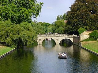
The River Cam is the main river flowing through Cambridge in eastern England. After leaving Cambridge, it flows north and east before joining the River Great Ouse to the south of Ely, at Pope's Corner. The total distance from Cambridge to the sea is about 40 mi (64 km) and is navigable for punts, small boats, and rowing craft. The Great Ouse also connects to England's canal system via the Middle Level Navigations and the River Nene. In total, the Cam runs for around 69 kilometres (43 mi) from its furthest source to its confluence with the Great Ouse.

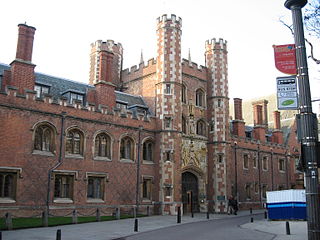
Magdalene College is a constituent college of the University of Cambridge. The college was founded in 1428 as a Benedictine hostel, in time coming to be known as Buckingham College, before being refounded in 1542 as the College of St Mary Magdalene.

Duroliponte or Durolipons was a small town in the Roman province of Britannia on the site of what is now the city of Cambridge.

Jesus Lock is a lock on the River Cam in the north of central Cambridge, England. This is Lock No. 1 on the navigable portion of the River Cam. It was built in 1836 and is the only lock in the city. Jesus Green Lock Cottage, the former lock-keeper's cottage, is by the lock on Jesus Green. It is owned by the Conservators of the River Cam and is rented out to students.

Northampton St. John's Street was a railway station and the northern terminus of the Midland Railway's former Bedford to Northampton Line which served the town of Northampton in Northamptonshire, England from 1872 to 1939. Its closure came about as a cost-cutting measure implemented by the London, Midland and Scottish Railway which diverted services to the nearby Northampton Castle station. After closure the elegant station building was used as offices and the line for the storage of rolling stock; the site was cleared in 1960 to make way for a car park. The car park has now been built on and is the location of St Johns Halls of Residence for The University of Northampton.

Jesus Green is a park in the north of central Cambridge, Cambridgeshire, England, north of Jesus College. Jesus Ditch runs along the southern edge Jesus Green. On the northern edge of Jesus Green is the River Cam, with Chesterton Road on the opposite side. To the east is Victoria Avenue and beyond that Midsummer Common, common land that is still used for grazing. Victoria Avenue crosses the Cam at Victoria Bridge, connecting to Chesterton Road, at the northeastern corner of Jesus Green.

Madingley Road is a major arterial road linking central Cambridge, England with Junction 13 of the M11 motorway. It passes by West Cambridge, a major new site where some University of Cambridge departments are being relocated.
St John's Street is a historical street in central Cambridge, England. The street links with Bridge Street, Round Church Street, and Sidney Street to the north. It continues to the south as Trinity Street, then King's Parade and Trumpington Street. This thoroughfare is the main area for some of the most historic University of Cambridge colleges.
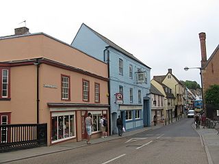
Magdalene Street is a street in the north of central Cambridge, England. It runs between Castle Street, by Castle Hill, at the junction with Northampton Street and Chesterton Lane, then Chesterton Road, to the northwest and Bridge Street at the junction with Thompson's Lane to the southeast.

Queen's Road is a major road to the west of central Cambridge, England. It links with Madingley Road and Northampton Street to the north and with Sidgwick Avenue, Newnham Road and Silver Street to the south.
Bridge Street is a historic street in the north of central Cambridge, England. It runs between Magdalene Street at the junction with Thompson's Lane to the northwest and Sidney Street at the junction with Jesus Lane to the southeast. Bridge Street used to continue over the Great Bridge on the River Cam, hence the name, but this part is now known as Magdalene Street after Magdalene College, which fronts onto the street.
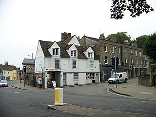
Castle Street is a street in the north of central Cambridge, England. To the southeast is a junction with Northampton Street, Magdalene Street, and Chesterton Lane. To the northwest is a junction with Mount Pleasant, Huntingdon Road, Histon Road, and Victoria Road.

Market Hill is the location of the marketplace in central Cambridge, England. Operating as a marketplace since Saxon times, a daily outdoor market with stalls continues to run there.

Petty Cury is a pedestrianised shopping street in central Cambridge, England. It connects Market Hill, the location of Cambridge's central outdoor market, and Guildhall Street to the west with the shopping streets of Sidney Street and St Andrew's Street to the east. Hobson Street leads off north on the opposite side of the street at the eastern end, on the corner of Christ's College, one of the historic University of Cambridge colleges.

Chesterton Road is a road in the north of Cambridge, England.

Elizabeth Way is a road in northeast Cambridge, England. It is designated the A1134 and forms part of Cambridge's inner ring road. At the northern end is a roundabout forming a junction with Milton Road. Near the north end is another roundabout linking with Chesterton Road to the west. At the southern end there is a roundabout that links with East Road and Newmarket Road.

Victoria Road is a residential road in the north of Cambridge, England. The road is designated the A1134. At the western end, the road links with Histon Road, Huntingdon Road, Mount Pleasant, and Castle Street.In 1950, there were plans to improve this junction, but they never came to fruition. At the eastern end it links with Chesterton Road (A1303) and also links to Milton Road, the A1134, then A1309, northeast out of the city, also linking with the A14.

The School of Pythagoras is the oldest building in St John's College, Cambridge, and the oldest secular building in Cambridge, England. It is a Grade I listed building. To the north is Northampton Street.
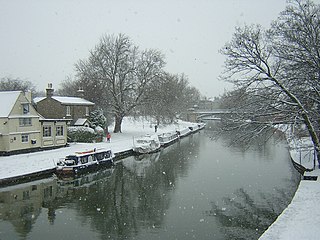
Victoria Bridge is a single-arch road bridge across the River Cam in Cambridge, England. It carries Victoria Avenue. Immediately to the north is Chesterton Road and a major junction with Victoria Road and Milton Road.
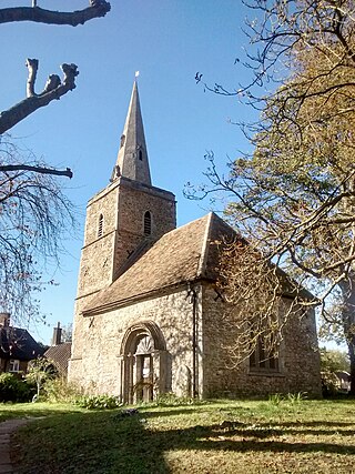
The Church of St Peter is a redundant Church of England (Anglican) church in Cambridge, in the Parish of the Ascension of the Diocese of Ely, located on Castle Street between Honey Hill and Kettle's Yard. The church is now in the care of the Churches Conservation Trust.

