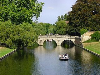
The River Cam is the main river flowing through Cambridge in eastern England. After leaving Cambridge, it flows north and east before joining the River Great Ouse to the south of Ely, at Pope's Corner. The total distance from Cambridge to the sea is about 40 mi (64 km) and is navigable for punts, small boats, and rowing craft. The Great Ouse also connects to England's canal system via the Middle Level Navigations and the River Nene. In total, the Cam runs for around 69 kilometres (43 mi) from its furthest source to its confluence with the Great Ouse.

A hillfort is a type of fortified refuge or defended settlement located to exploit a rise in elevation for defensive advantage. They are typical of the late European Bronze Age and Iron Age. Some were used in the post-Roman period. The fortification usually follows the contours of a hill and consists of one or more lines of earthworks or stone ramparts, with stockades or defensive walls, and external ditches. If enemies were approaching, the civilians would spot them from a distance.

Maiden Castle is an Iron Age hillfort 1.6 mi (2.6 km) southwest of Dorchester, in the English county of Dorset. Hill forts were fortified hill-top settlements constructed across Britain during the Iron Age.

The Fosse Way was a Roman road built in Britain during the first and second centuries AD that linked Isca Dumnoniorum (Exeter) in the southwest and Lindum Colonia (Lincoln) to the northeast, via Lindinis (Ilchester), Aquae Sulis (Bath), Corinium (Cirencester), and Ratae Corieltauvorum (Leicester).

Ordu Province is a province and metropolitan municipality of Turkey, located on the Black Sea coast. Its area is 5,914 km2, and its population is 763,190 (2022). Its adjacent provinces are Samsun to the northwest, Tokat to the southwest, Sivas to the south, and Giresun to the east. Its license-plate code is 52. The capital of the province is the city of Ordu.

Belvoir Castle, also called Coquet by the Crusaders, also Kochav HaYarden and Kawkab al-Hawa, is a Crusader castle in northern Israel, on a hill on the eastern edge of the Issachar Plateau, on the edge of Lower Galilee 20 kilometres (12 mi) south of the Sea of Galilee. Gilbert of Assailly, Grand Master of the Knights Hospitaller, began construction of the castle in 1168. The castle ruin is located in Belvoir National Park, officially Kochav HaYarden National Park. It is the best-preserved Crusader castle in Israel.

Kōchi Castle is an Edo Period Japanese castle in the city of Kōchi, Kōchi Prefecture, Japan. It is located at Otakayama hill, at the center of Kōchi city, which in turn is located at the center of the Kōchi Plain, the most prosperous area of former Tosa Province on the island of Shikoku. From 1601 to 1871, it was the center of Tosa Domain, ruled by the tozama Yamauchi clan under the Tokugawa Shogunate. The castle site has been protected as a National Historic Site since 1959, with the area under protection expanded in 2014.

Lydney Park is a 17th-century country estate surrounding Lydney House, located at Lydney in the Forest of Dean district in Gloucestershire, England. It is known for its gardens and Roman temple complex.

British Camp is an Iron Age hill fort located at the top of Herefordshire Beacon in the Malvern Hills. The hill fort is protected as a Scheduled Ancient Monument and is owned and maintained by Malvern Hills Conservators. The fort is thought to have been first constructed in the 2nd century BC. A Norman castle was built on the site.

Fleam Dyke is a linear earthwork between Fulbourn and Balsham in Cambridgeshire, initiated some time between AD 330 and AD 510. It is three miles long and seven metres high from ditch to bank, and its ditch faces westwards, implying invading Saxons as its architects. Later, it formed a boundary of the Anglo-Saxon administrative division of Flendish Hundred. At a prominent point, the earthwork runs beside Mutlow Hill, crowned by a 4000-year-old Bronze Age burial mound.

Duroliponte or Durolipons was a small town in the Roman province of Britannia on the site of what is now the city of Cambridge.

Oshida or Mount Khwaja or Mount Khwajeh is a flat-topped black basalt hill rising up as an island in the middle of Lake Hamun, in the Iranian province of Sistan and Baluchestan.
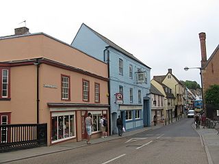
Magdalene Street is a street in the north of central Cambridge, England. It runs between Castle Street, by Castle Hill, at the junction with Northampton Street and Chesterton Lane, then Chesterton Road, to the northwest and Bridge Street at the junction with Thompson's Lane to the southeast.

Northampton Street is a street in the north of central Cambridge, England. It runs between Madingley Road and Queen's Road to the west and Castle Street, by Castle Hill, Chesterton Lane, and Magdalene Street to the east.

Hills Road is an arterial road in southeast Cambridge, England. It runs between Regent Street at the junction with Lensfield Road and Gonville Place to the northwest and a roundabout by the Cambridge Biomedical Campus, continuing as Babraham Road to the southeast.
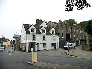
Castle Street is a street in the north of central Cambridge, England. To the southeast is a junction with Northampton Street, Magdalene Street, and Chesterton Lane. To the northwest is a junction with Mount Pleasant, Huntingdon Road, Histon Road, and Victoria Road.

Huntingdon Road is a major arterial road linking central Cambridge, England with Junction 14 of the M11 motorway and the A14 northwest from the city centre. The road, designated the A1307, follows the route of the Roman Via Devana, and is named after the town of Huntingdon, northwest of Cambridge.
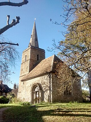
The Church of St Peter is a redundant Church of England (Anglican) church in Cambridge, in the Parish of the Ascension of the Diocese of Ely, located on Castle Street between Honey Hill and Kettle's Yard. The church is now in the care of the Churches Conservation Trust.
Warham Camp is an Iron Age circular hill fort with a total diameter of 212 metres near Warham, south of Wells-next-the-Sea in Norfolk. It is a scheduled monument dated to between 800BC and 43AD, and a 5.1-hectare (13-acre) biological Site of Special Scientific Interest, located within the Norfolk Coast Area of Outstanding Natural Beauty. The University of East Anglia has described it as the best-preserved hill fort in Norfolk.

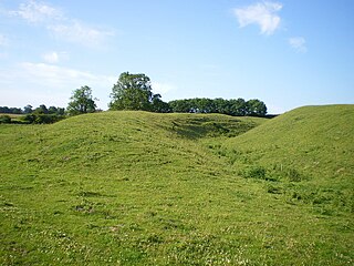
Wandlebury Hill Fort, also known as the Wandlebury Ring, is an Iron Age hillfort located on Wandlebury Hill in the Gog Magog Hills, Cambridgeshire, England, to the southeast of Cambridge. Now a country park, it was the most important of three hillforts in the downs.

