Castle Street, Cambridge

Last updated

The Museum of Cambridge, on the corner of Castle Street and Northampton Street. Cambridge & County Folk Museum - geograph.org.uk - 631123.jpg
The Museum of Cambridge, on the corner of Castle Street and Northampton Street.
View down Castle Street with the Cambridge Castle gate from Memorials of Cambridge by Le Keux (1845). Le Keux Castle Street.jpg
View down Castle Street with the Cambridge Castle gate from Memorials of Cambridge by Le Keux (1845).

Castle Street is a street in the north of central Cambridge, England. [1] [2] To the southeast is a junction with Northampton Street, Magdalene Street, and Chesterton Lane (leading to Chesterton Road). To the northwest is a junction with Mount Pleasant, Huntingdon Road (leading northwest out of Cambridge), Histon Road (leading north out of Cambridge), and Victoria Road. [3]

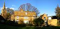
To the northeast is St Giles' Church, Castle Hill, the location of Cambridge Castle, and the Cambridgeshire Shire Hall. To the southwest is St Peter's Church and Honey Hill. On the corner of Castle Street and Northampton Street is the Museum of Cambridge, formerly the Cambridge & County Folk Museum. [4] Also here is Kettle's Yard, a former home and now a modern art gallery and place for reflection. [5]

St Giles' Church, St Peter's Church and Castle Street Methodist Church are beside the street. [6] The Castle Inn public house is also located here. [2]

Related Research Articles

<span class="mw-page-title-main">Cambridge</span> City in Cambridgeshire, England

Cambridge is a university city and the county town in Cambridgeshire, England. It is located on the River Cam approximately 55 miles (89 km) north of London. As of the 2021 United Kingdom census, the population of Cambridge was 145,700. Cambridge became an important trading centre during the Roman and Viking ages, and there is archaeological evidence of settlement in the area as early as the Bronze Age. The first town charters were granted in the 12th century, although modern city status was not officially conferred until 1951.

<span class="mw-page-title-main">Kettle's Yard</span> Art museum & house in Cambridge, England

Kettle's Yard is an art gallery and house in Cambridge, England. The director of the art gallery is Andrew Nairne. Both the house and gallery reopened in February 2018 after an expansion of the facilities.

<span class="mw-page-title-main">Bramhope</span> Village and civil parish in West Yorkshire, England

Bramhope is a village and civil parish in the City of Leeds metropolitan borough, West Yorkshire, England, north of Holt Park and north east of Cookridge.

Histon is a village and civil parish in the South Cambridgeshire district, in the county of Cambridgeshire, England. It is immediately north of Cambridge – and is separated from the city – by the A14 road which runs east–west. In 2011 the parish had a population of 4655. Histon forms part of the Cambridge built-up area.

<span class="mw-page-title-main">A505 road</span> Road in southern England

The A505 is an A-class road in England. It follows part of the route of the Icknield Way and the corresponding Icknield Way Path and runs from Leighton Buzzard in Bedfordshire to the A11 Abington Interchange North in Cambridgeshire.

<span class="mw-page-title-main">Duroliponte</span>

Duroliponte or Durolipons was a small town in the Roman province of Britannia on the site of what is now the city of Cambridge.

The Cambridge and St Ives branch was a railway built by the Wisbech, St Ives & Cambridge Junction Railway in the late 1840s. The railway ran from Cambridge in the south, through Fenland countryside to the market town of St Ives; more specifically, the line ran from Chesterton Junction, where it met the present-day Fen line north of the River Cam.

<span class="mw-page-title-main">Arbury</span> Human settlement in England

Arbury is a district and electoral ward of the city of Cambridge, England. The ward borders the following other wards : Histon, King's Hedges, West Chesterton, Market and Castle.

<span class="mw-page-title-main">Magdalene Street</span> Street in Cambridge, England

Magdalene Street is a street in the north of central Cambridge, England. It runs between Castle Street, by Castle Hill, at the junction with Northampton Street and Chesterton Lane, then Chesterton Road, to the northwest and Bridge Street at the junction with Thompson's Lane to the southeast.

<span class="mw-page-title-main">Northampton Street, Cambridge</span> Street in the north of central Cambridge, England

Northampton Street is a street in the north of central Cambridge, England. It runs between Madingley Road and Queen's Road to the west and Castle Street, by Castle Hill, Chesterton Lane, and Magdalene Street to the east.

<span class="mw-page-title-main">Huntingdon Road</span>

Huntingdon Road is a major arterial road linking central Cambridge, England with Junction 14 of the M11 motorway and the A14 northwest from the city centre. The road is designated the A1307, follows the route of the Roman Via Devana, and is named after the town of Huntingdon, northwest of Cambridge.

<span class="mw-page-title-main">Victoria Road, Cambridge</span>

Victoria Road is a residential road in the north of Cambridge, England. The road is designated the A1134. At the western end, the road links with Histon Road, Huntingdon Road, Mount Pleasant, and Castle Street.In 1950, there were plans to improve this junction, but they never came to fruition. At the eastern end it links with Chesterton Road (A1303) and also links to Milton Road, the A1134, then A1309, northeast out of the city, also linking with the A14.

<span class="mw-page-title-main">Histon Road</span>

Histon Road is an arterial road linking central Cambridge, England with the A14 road north of the city. The road is designated the B1049. At the southern end, the road links with Huntingdon Road (A1307), Victoria Road (A1134), Mount Pleasant, and Castle Street. At the northern end of the road it continues just south of the A14 as Cambridge road into the village of Impington.

<span class="mw-page-title-main">St Peter's Church, Cambridge</span>

The Church of St Peter is a redundant Church of England (Anglican) church in Cambridge, in the Parish of the Ascension of the Diocese of Ely, located on Castle Street between Honey Hill and Kettle's Yard. The church is now in the care of the Churches Conservation Trust.

<span class="mw-page-title-main">St Giles' Church, Cambridge</span> Church in Cambridge , United Kingdom

The Church of St Giles is a Grade II*-listed church in Cambridge, England. It is a Church of England parish church in the Parish of the Ascension of the Diocese of Ely, located on the junction of Castle Street and Chesterton Road. It was completed and consecrated by the Bishop of Ely in 1875, to replace an earlier church founded in 1092. The church, which added "with St Peter" to its appellation when the neighbouring St Peter's Church became redundant, is home to both an Anglican and a Romanian Orthodox congregation and is used as a venue for concerts and other events. It also serves as a main location of the Cambridge Churches Homeless Project.

References

  1. Castle Street, Cambridge Online.
  2. 1 2 Locale Castle Street, The Open Guide to Cambridge.
  3. Cambridge 1950: Histon Road — Huntingdon Road — Victoria Road junction, Cambridge 1950.
  4. "the folk museum is changing its name!". www.folkmuseum.org. Archived from the original on 7 August 2013. Retrieved 17 November 2013.
  5. Kettle's Yard, Castle Street, Cambridge Archived 24 October 2008 at archive.today , doNOWdo.
  6. Castle Street Methodist Church.

Coordinates: 52°12′39″N0°06′50″E / 52.21092°N 0.114°E / 52.21092; 0.114