Related Research Articles

William Light, also known as Colonel Light, was a British-Malayan naval and army officer. He was the first Surveyor-General of the new British Province of South Australia, known for choosing the site of the colony's capital, Adelaide, and for designing the layout of its streets, six city squares, gardens and the figure-eight Adelaide Park Lands, in a plan later sometimes referred to as Light's Vision.

This article details the History of Adelaide from the first human activity in the region to the 20th century. Adelaide is a planned city founded in 1836 and the capital of South Australia.

The Supreme Court of South Australia is the superior court of the Australian state of South Australia. The Supreme Court is the highest South Australian court in the Australian court hierarchy. It has unlimited jurisdiction within the state in civil matters, and hears the most serious criminal matters. The Court is composed of a Chief Justice and as many other judges as may be required.

Light Square, also known as Wauwi, is one of five public squares in the Adelaide city centre. Located in the centre of the north-western quarter of the Adelaide city centre, its southern boundary is Waymouth Street, while Currie Street crosses its northern tip, isolating about a quarter of its land. Morphett Street runs through the centre in a north–south direction.
Hindmarsh Square/Mukata is one of five public squares in the Adelaide city centre, South Australia. It is located in the centre of the north-eastern quarter of the city, and surrounds the intersection of Grenfell and Pulteney Streets, near the eastern end of the Rundle Mall. Pirie Street forms the southern boundary of the square.

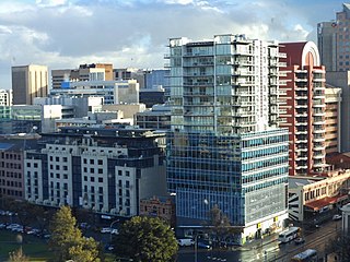
Adelaide city centre is the inner city locality of Greater Adelaide, the capital city of South Australia. It is known by locals simply as "the City" or "Town" to distinguish it from Greater Adelaide and from the City of Adelaide local government area. The population was 15,115 in the 2016 census.

Hurtle Square, also known as Tangkaira, is one of five public squares in the Adelaide city centre, South Australia. Located in the centre of the south-eastern quarter of the city, it surrounds the intersection of Halifax and Pulteney Streets. Its north edge is bounded by Carrington Street.

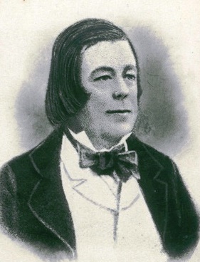
Sir John William Jeffcott was the first judge of the Supreme Court of South Australia. He also served as Chief Justice of Sierra Leone.

Sir James Hurtle Fisher was a lawyer and prominent South Australian pioneer. He was the first Resident Commissioner of the colony of South Australia, the first Mayor of Adelaide and the first resident South Australian to be knighted.

Pulteney Street is a main road which runs north-south through the middle of the eastern half of the Adelaide city centre, in Adelaide, South Australia. It runs north-south from North Terrace, through Hindmarsh and Hurtle Squares, to South Terrace, where it becomes Unley Road. It is the only one of the city centre's major north-south thoroughfares that does not continue northwards over North Terrace.

Sir John Morphett was a South Australian pioneer, landowner and politician. His younger brother George Morphett was also an early settler in South Australia.
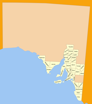
The lands administrative divisions of South Australia are the cadastral units of counties and hundreds in South Australia. They are located only in the south-eastern part of the state, and do not cover the whole state. 49 counties have been proclaimed across the southern and southeastern areas of the state historically considered to be arable and thus in need of a cadastre. Within that area, a total of 540 hundreds have been proclaimed, although five were annulled in 1870, and, in some cases, the names reused elsewhere.

Thomas Gilbert (1786–1873), a pioneer in South Australia, was its first Colonial Storekeeper and its first Postmaster. He was also a fourth-generation mathematical instrument maker and optician in England, his family being highly regarded in this field at the time.

John Barton Hack was an early settler in South Australia; a prominent farmer, businessman and public figure. He lost his fortune in the financial crisis of 1840 and despite his best efforts, never regained anything like his former influence and prosperity. His son Theodore Hack, younger brother Stephen Hack and nephew Wilton Hack were all figures of some significance in the history of the Colony.
Thomas Bewes Strangways, generally called "Bewes Strangways" and "T. Bewes Strangways", was an explorer, early settler and Colonial Secretary of South Australia.

North Adelaide is a predominantly residential precinct and suburb of the City of Adelaide in South Australia, situated north of the River Torrens and within the Adelaide Park Lands.
William Williams was an early settler in the Province of South Australia, known for establishing the Walkerville Brewery and for his work on the Kaurna language. He was Deputy Colonial Storekeeper for some time.
Strangways Terrace is a street in North Adelaide, South Australia. It is the southwestern boundary between the built environment and the Adelaide parklands including the Adelaide Golf Links.
O'Connell Street is the main north–south route through North Adelaide, South Australia and is heavily-trafficked by north-suburban commuters to Adelaide city centre. At its northern end it intersects with Barton Terrace West and the commencement of Prospect and Main North roads. At its southern end it abuts Brougham Gardens and intersects with Brougham Place and the commencement of King William Road. It is considered to be one of two major shopping and dining strips within North Adelaide, the other being Melbourne Street.
Jeffcott Street is a north–south street through the largest section of North Adelaide, South Australia. It goes around the sides of Wellington Square. The southern end continues south as Montefiore Road over a bridge over the River Torrens and Adelaide Metro railyards to connect with the northern end of Morphett Street.
References
- 1 2 3 4 Elton, Jude (29 December 2022). "Street Naming Committee". SA History Hub.
- 1 2 3 "Nomenclature of the Streets of Adelaide and North Adelaide" (PDF). State Library of South Australia . Retrieved 29 December 2022.
- ↑ Manning, Geoff. "Streets by name". Manning Index of South Australian History. State Library of South Australia . Retrieved 29 December 2022.
- ↑ "Kermode, Robert Quayle (1812–1870)". Australian Dictionary of Biography. Retrieved 22 February 2015.