
Transportation in the Philippines covers the transportation methods within the archipelagic nation of over 7,600 islands. From a previously underdeveloped state of transportation, the government of the Philippines has been improving transportation through various direct infrastructure projects, and these include an increase in air, sea, road, and rail transportation and transport hubs.
Act, ACT, or The Act may refer to:

Epifanio de los Santos Avenue, commonly referred to by its acronym EDSA, is a limited-access circumferential highway around Manila, the capital city of the Philippines. It passes through 6 of Metro Manila's 17 local government units or cities, namely, from north to south, Caloocan, Quezon City, San Juan, Mandaluyong, Makati, and Pasay.

Tarlac City, officially the City of Tarlac, is a 1st class city and the capital of the province of Tarlac, Philippines. According to the 2020 census, it has a population of 385,398 people making it the most populous in the province.
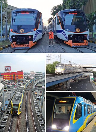
Rail transportation in the Philippines is currently used mostly to transport passengers within Metro Manila and provinces of Laguna and Quezon, as well as a commuter service in the Bicol Region. Freight transport services once operated in the country, but these services were halted. However, there are plans to restore old freight services and build new lines. From a peak of 1,100 kilometers (680 mi), the country currently has a railway footprint of 533.14 kilometers (331.28 mi), of which only 129.85 kilometers (80.69 mi) are operational as of 2024, including all the urban rail lines. World War II, natural calamities, underspending, and neglect have all contributed to the decline of the Philippine railway network. In the 2019 Global Competitiveness Report, the Philippines has the lowest efficiency score among other Asian countries in terms of efficiency of train services, receiving a score of 2.4, and ranking 86th out of 101 countries globally. The government is currently expanding the railway network up to 1,900 kilometers (1,200 mi) by 2022 through numerous projects.

The Strong Republic Transit System (SRTS) was a program initiated by President Gloria Macapagal Arroyo on June 14, 2003, aimed at integrating the various rail lines providing public transport in Metro Manila, Philippines. It aimed to provide a "reliable, seamless and integrated mass transit system that would be at par with international standards" by unifying existing rail infrastructure under one transit system and fare structure. The Manila Light Rail Transit System (Line 1 and Line 2), the Manila Metro Rail Transit System (Line 3) and the Philippine National Railways (PNR) Northrail and Southrail lines were covered by the SRTS project.

The Philippine Nautical Highway System, also the Road Roll-on/Roll-off Terminal System (RRTS) or simply the RoRo System, is an integrated network of highway and vehicular ferry routes which forms the backbone of a nationwide vehicle transport system in the Philippines. It is a system of roads and ports developed by the Philippine government to connect the major islands of Luzon, the Visayas and Mindanao. The 919-kilometer (571 mi) nautical highway was opened to the public on April 12, 2003 as the Strong Republic Nautical Highway (SRNH).

Commonwealth Avenue, formerly known as Don Mariano Marcos Avenue, is a 12.4-kilometer (7.7 mi) highway located in Quezon City, Philippines. It spans six to eighteen lanes, making it the widest road in the country. The avenue is one of the major roads in Metro Manila and is designated as part of Radial Road 7 (R-7) of the older Manila arterial road system and National Route 170 (N170) of the Philippine highway network.
Google Maps Navigation is a mobile application developed by Google for the Android and iOS operating systems that later integrated into the Google Maps mobile app. The application uses an Internet connection to a GPS navigation system to provide turn-by-turn voice-guided instructions on how to arrive at a given destination. The application requires a connection to Internet data and normally uses a GPS satellite connection to determine its location. A user can enter a destination into the application, which will plot a path to it. The app displays the user's progress along the route and issues instructions for each turn.

The transportation system in Metro Manila covers the road network, rail network, ferries, ports and airports located within the metropolitan Manila area. Road transportation in Metro Manila is diverse, composed of many types of private and public transport vehicles. These include taxis, buses, jeepneys, tricycles and pedicabs. In some areas, especially in Divisoria and large public markets, two-stroke motors are fitted in the pedicabs and are used for goods transport. Regardless of modernity, horse-drawn kalesas are still used in the streets of Binondo and Intramuros. Ridesharing services such as Grab also operate within Metro Manila.

The visa policy of Lebanon deals with the requirements which a foreign national wishing to enter the Republic of Lebanon must meet to be permitted to travel to, enter and remain in the country.

Visitors to Nicaragua must obtain a visa from one of the Nicaraguan diplomatic missions, unless they come from one of the visa exempt countries or countries that can obtain a visa on arrival. All visitors must hold a passport valid for 6 months.

Visitors to Egypt must obtain a visa from one of the Egyptian diplomatic missions unless they come from one of the visa exempt countries or countries that are eligible for visa on arrival.
The Philippine highway network is a network of national roads owned and maintained by the Department of Public Works and Highways (DPWH) and organized into three classifications according to their function or purpose: national primary, secondary, and tertiary roads. The national roads connecting major cities are numbered from N1 to N83. They are mostly single and dual carriageways linking two or more cities.
The Philippine expressway network, also known as the High Standard Highway Network, is a controlled-access highway network managed by the Department of Public Works and Highways (DPWH) which consists of all expressways and regional high standard highways in the Philippines.
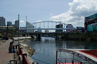
The Guadalupe Bridge is a road bridge crossing the Pasig River in Metro Manila, Philippines, linking the cities of Makati and Mandaluyong. It serves as a conduit for EDSA and the MRT Line 3.

Tandang Sora Avenue is a major east-west thoroughfare bisecting Quezon City in Metro Manila, Philippines. It is a two-to-six-lane highway and municipal road that runs for 9.6 kilometers (6.0 mi) from its eastern terminus at Magsaysay Avenue in Pansol and U.P. Campus in Diliman to its western terminus at Quirino Highway in Baesa and Talipapa in Novaliches, crossing Barangays Culiat, New Era, Pasong Tamo, Tandang Sora, and Sangandaan.
National Route 170 (N170) is a national secondary road of the Philippine highway network. It passes through the northern part of Metro Manila, traversing through the cities of Quezon City, Manila, and Pasay.