
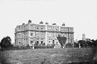
Stubbers was a stately home in North Ockendon, Essex, England. The house was demolished in 1955 and the grounds became the Stubbers Activity Centre in 2011.
Stubbers was a stately home in North Ockendon, Essex, England. The house was demolished in 1955 and the grounds became the Stubbers Activity Centre in 2011.
The earliest reference to the estate subsequently known as Stubbers was in 1334. The name comes from William Stubber who owned the house in the 15th century. [1] In the early 17th century it was the home of William Coys, a well known botanist, who established a walled garden that subsequently provided plants for the establishment of Kew Gardens. [2] The garden contained 342 plant species and in 1604 a yucca plant bloomed there, for the first time in England. [3] In the book Early English Botanists Coys is attributed with compiling a list of his plants for John Goodyer of Hampshire, this being described as the oldest known list of plants from an English garden giving their scientific names. [4]
In 1689, the estate was bought by Sir William Russell, a London draper who included King Charles II among his acquaintances. [4] Stubbers remained in the Russel family for nearly 300 years, and Humphry Repton was commissioned to suggest how the gardens could be landscaped for which he produced a "Red Book". [5] On Repton's advice, the Coys garden was removed. [6] Writing in 1951, before the house was demolished, Glynn Morgan described the southern facade as "attractive". [7] To the east of the house was a dovecote with 662 nesting boxes.

The house was demolished in 1955 and the grounds are now the site of an activity centre. [8] In August 2011, it was announced that Havering Council had agreed to sell the land to the activity centre. [9]
51°32′18″N0°16′02″E / 51.5384146°N 0.267266°E [1]

Cranham is a residential area of east London, and part of the London Borough of Havering. It is located 17.5 miles (28 km) east-northeast of Charing Cross and comprises an extensive built-up area to the north and a low density conservation area to the south surrounded by open land. It was historically a rural village in the county of Essex and formed an ancient parish. It is peripheral to London, forming the eastern edge of the urban sprawl. The economic history of Cranham is characterised by a shift from agriculture to housing development. As part of the suburban growth of London in the 20th century, Cranham significantly increased in population, becoming part of Hornchurch Urban District in 1934 and has formed part of Greater London since 1965. The 2011 Census population of Cranham was included in Upminster.

Hornchurch is a suburban town in East London in the London Borough of Havering. It is located 15.2 miles (24.5 km) east-northeast of Charing Cross. It comprises a number of shopping streets and a large residential area. It historically formed a large ancient parish in the county of Essex that became the manor and liberty of Havering. The economic history of Hornchurch is underpinned by a shift away from agriculture to other industries with the growing significance of nearby Romford as a market town and centre of administration. As part of the suburban growth of London in the 20th century, Hornchurch significantly expanded and increased in population, becoming an urban district in 1926 and has formed part of Greater London since 1965. It is the location of Queen's Theatre, Havering Sixth Form College and Havering College of Further and Higher Education.

Upminster is a suburban town in East London, England, within the London Borough of Havering. Located 16.5 miles (26.6 km) east-northeast of Charing Cross, it is one of the locally important district centres identified in the London Plan.

The London Borough of Havering in East London, England, forms part of Outer London. It has a population of 259,552 inhabitants; the principal town is Romford, while other communities include Hornchurch, Upminster, Collier Row and Rainham. The borough is mainly suburban, with large areas of protected open space. Romford is a major retail and night time entertainment centre, and to the south the borough extends into the London Riverside redevelopment area of the Thames Gateway. The name Havering is a reference to the Royal Liberty of Havering which occupied the area for several centuries. The local authority is Havering London Borough Council. It is the easternmost London borough.

Emerson Park is a suburban neighbourhood in the London Borough of Havering, east London. The neighbourhood developed as two large housing estates built on the 550 acres (2.2 km2) estate of Nelmes manor in the parish of Hornchurch. Emerson Park estate to the south started construction in 1895 and Great Nelmes estate to the north was begun in 1901. It is located north of the Romford–Upminster line and a station opened at Emerson Park in 1909. The mansion of Nelmes survived until it was demolished in 1967 to avoid preservation by the Civic Amenities Act and was replaced with a small housing estate called The Witherings. Emerson Park is located 15 miles (24.1 km) northeast of Charing Cross in Central London.

Humphry Repton was the last great designer of the classic phase of the English landscape garden, often regarded as the successor to Capability Brown. His style is thought of as the precursor of the more intricate and eclectic styles of the 19th century. His first name is often incorrectly spelt "Humphrey".

Russell Square is a large garden square in Bloomsbury, in the London Borough of Camden, built predominantly by the firm of James Burton. It is near the University of London's main buildings and the British Museum. Almost exactly square, to the north is Woburn Place and to the south-east is Southampton Row. Russell Square tube station sits to the north-east.
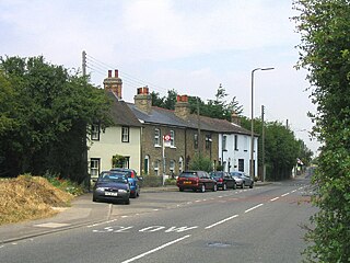
North Ockendon is the easternmost settlement of Greater London, England, and part of the London Borough of Havering. It is 18 miles (29 km) east-northeast of Central London and consists of a dispersed settlement within the Metropolitan Green Belt. It was historically an ancient parish in the county of Essex, which was abolished for civil purposes in 1936. North Ockendon is the only inhabited area in Greater London outside the M25 London Orbital Motorway. North Ockendon is north of South Ockendon, in Thurrock, Essex.
South Ockendon is a town, former civil parish and Church of England parish within the Thurrock borough in Essex in the East of England, United Kingdom. It is located on the border with Greater London, just outside the M25 motorway. The area to the north is North Ockendon. In 2019 it had an estimated population of 22,303 and in the 2021 United Kingdom census it had a population of 22,442
Langtons House and Langtons Gardens are a grade II listed 18th century house and landscaped gardens located in Hornchurch, in the London Borough of Havering, Greater London. The house and gardens became local authority property in 1929 and are currently used as the borough register office and a public park. Langtons House was used as the council offices of Hornchurch Urban District Council from 1929 to 1965.

Mottisfont Abbey is a historical priory and country estate in Hampshire, England. Sheltered in the valley of the River Test, the property is now operated by the National Trust. 393,250 people visited the site in 2019. The site includes the historic house museum which features regularly changing art exhibitions, gardens, including a walled rose garden which is home to the National Plant Collection of ancestral rose species and 19th-century rose cultivars, and a riverside walk. It is a Grade I listed building.

Blaise Castle is a folly built in 1766 near Henbury in Bristol, England. The castle sits within the Blaise Castle Estate, which also includes Blaise Castle House, a Grade II* listed 18th-century mansion house. The folly castle is also Grade II* listed and ancillary buildings including the orangery and dairy also have listings. Along with Blaise Hamlet, a group of nine small cottages around a green built in 1811 for retired employees, and various subsidiary buildings, the parkland is listed Grade II* on the Register of Historic Parks and Gardens of special historic interest in England.

Cassiobury Park is the principal public park in Watford, Hertfordshire, in England. It was created in 1909 from the purchase by Watford Borough Council of part of the estate of the Earls of Essex around Cassiobury House which was subsequently demolished in 1927. It comprises over 190 acres (77 ha) and extends from the A412 Rickmansworth Road in the east to the Grand Union Canal in the west, and lies to the south of the Watford suburb of Cassiobury, which was also created from the estate. The western part is a 62-acre (25.1 ha) Local Nature Reserve managed by the Herts and Middlesex Wildlife Trust. The park hosts the free, weekly timed parkrun 5 km event every Saturday morning at 9 am, starting on the field near the Shepherds Road entrance to the park, and finishing by the bandstand.

Bedfords Park is public open space of 215 acres or approximately 87½ hectares near Havering-atte-Bower in the London Borough of Havering in England. It is one of three large parklands around Havering-atte-Bower; the others are Havering Country Park and Pyrgo Park.

Hylands House is a Grade II* neo-classical villa situated within Hylands Park a 232-hectare park southwest of Chelmsford in Essex in South East England. It is owned and operated by Chelmsford City Council.
Gidea Hall was a manor house in Gidea Park, the historic parish and Royal liberty of Havering-atte-Bower, whose former area today is part of the north-eastern extremity of Greater London.

Stratton Park, in East Stratton, Hampshire, was an English country house, built on the site of a grange of Hyde Abbey after the dissolution of the monasteries; it was purchased with the manor of Micheldever in 1546 by Thomas Wriothesley, 1st Earl of Southampton. The last earl of Southampton made Stratton Park one of his chief seats, and his son-in-law, Sir William Russell, pulled down part of the hamlet and added it to his deer park in the 1660s. The Russell heirs eventually sold the estate in 1801 to Sir Francis Baring, Bt, of the Baring banking family. Baring remodeled the manor house in a neoclassical style, to designs by George Dance the Younger, 1803–06,' including an imposing stone Doric-columned portico and stuccoed brick main block and wings. The pleasure grounds and landscape park were laid out and planted, starting ca 1803 by Humphry Repton, and described by William Cobbett, in Rural Rides: in the counties of Surrey, Kent, Sussex, Hants, when Stratton Park held the living of Micheldever and included Micheldever Wood, which Cobbett said "contains a thousand acres [4 km2], and which is one of the finest oak-woods in England." In the late nineteenth century Thomas Baring, 1st Earl of Northbrook laid out more formally structured gardens, with hardy plantings by Gertrude Jekyll. The park has been Grade II registered since 1984.

Panshanger was a large country house located between the outer edge of Hertford and Welwyn Garden City in Hertfordshire, England.

Wall Hall, originally known as Aldenham Abbey, is a country house at Aldenham in Hertfordshire, England. The main house and several ancillary buildings are Grade II listed. The gardens and parkland are also on the Register of Historic Parks and Gardens of Special Historic Interest in England.