
Lake Michigan is one of the five Great Lakes of North America. It is the second-largest of the Great Lakes by volume and the third-largest by surface area, after Lake Superior and Lake Huron. To the east, its basin is conjoined with that of Lake Huron through the 3+1⁄2-mile (5.6-kilometer) wide, 295-foot deep Straits of Mackinac, giving it the same surface elevation as its easterly counterpart; the two are geologically a single lake.

Lake Superior is the largest freshwater lake in the world by surface area and the third-largest by volume, holding 10% of the world's surface fresh water. Located in central North America, it is the northernmost and westernmost of the Great Lakes of North America, straddling the Canada–United States border with the Canadian province of Ontario to the north and east and the U.S. states of Minnesota to the west and Wisconsin and Michigan to the south. It drains into Lake Huron via St. Marys River, then through the lower Great Lakes to the St. Lawrence River and ultimately the Atlantic Ocean.

Lake Agassiz was a large proglacial lake that existed in central North America during late Pleistocene, fed by meltwater from the retreating Laurentide Ice Sheet at the end of the last glacial period. At its peak, the lake's area was larger than all of the modern Great Lakes combined.
The Red River is a river in the north-central United States and central Canada. Originating at the confluence of the Bois de Sioux and Otter Tail rivers between the U.S. states of Minnesota and North Dakota, it flows northward through the Red River Valley, forming most of the border of Minnesota and North Dakota and continuing into Manitoba. It empties into Lake Winnipeg, whose waters join the Nelson River and ultimately flow into Hudson Bay.

Lake Travis is a reservoir on the Colorado River in central Texas in the United States.

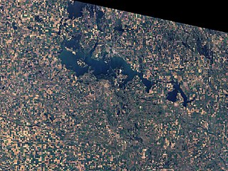
Lake Minnetonka is a lake located about 16 miles (26 km) west-southwest of Minneapolis, Minnesota. Lake Minnetonka has about 23 named bays and areas. The lake lies within Hennepin and Carver counties and is surrounded by 13 incorporated municipalities. At 14,528 acres (5,879 ha), it is Minnesota's ninth largest lake. It is a popular spot for local boaters, sailors, and fishermen.

The Yellowstone River is a tributary of the Missouri River, approximately 692 miles (1,114 km) long, in the Western United States. Considered the principal tributary of upper Missouri, via its own tributaries it drains an area with headwaters across the mountains and high plains of southern Montana and northern Wyoming, and stretching east from the Rocky Mountains in the vicinity of Yellowstone National Park. It flows northeast to its confluence with the Missouri River on the North Dakota side of the border, about 25 miles west of present-day Williston.
Devils Lake is a lake in the U.S. state of North Dakota. It is the largest natural body of water and the second-largest body of water in North Dakota after Lake Sakakawea. It can reach a level of 1,458 ft (444 m) before naturally flowing into the Sheyenne River via the Tolna Coulee. On June 27, 2011, it reached an unofficial historical high elevation of 1,454.3 ft (443.3 m). The cities of Devils Lake and Minnewaukan take their name from the lake as does the Spirit Lake Reservation, which is located on the lake's southern shores.

Otsego Lake is a 4,046-acre (16.37 km2) lake located in Otsego County in the U.S. state of New York. It is the source of the Susquehanna River and largest lake in Otsego County. The Village of Cooperstown is located at the lake's southern end. Glimmerglass State Park is located on the lake's northeastern shore, and includes Hyde Hall, a large mansion constructed in 1817, that overlooks the lake. The Glimmerglass Opera, opened in June 1987, is located on the western shore.

The Fort Peck Dam is the highest of six major dams along the Missouri River, located in northeast Montana in the United States, near Glasgow, and adjacent to the community of Fort Peck. At 21,026 feet (6,409 m) in length and over 250 feet (76 m) in height, it is the largest hydraulically filled dam in the United States, and creates Fort Peck Lake, the fifth largest artificial lake in the U.S., more than 130 miles (210 km) long, 200 feet (61 m) deep, and it has a 1,520-mile (2,450 km) shoreline which is longer than the state of California's coastline. It lies within the Charles M. Russell National Wildlife Refuge. The dam and the 134-mile-long (216 km) lake are owned and operated by the U.S. Army Corps of Engineers and exist for the purposes of hydroelectric power generation, flood control, and water quality management.

Lake Wawasee, formerly Turkey Lake, is a natural lake southeast of Syracuse in Kosciusko County, Indiana, United States. It is the largest natural lake wholly contained within Indiana. It is located just east of Indiana State Road 13.

Lake Allatoona is a U.S. Army Corps of Engineers reservoir on the Etowah River in northwestern part of the State of Georgia. This reservoir is mostly in southeastern Bartow County and southwestern Cherokee County. A small portion is located in Cobb County near Acworth.

Interstate Park comprises two adjacent state parks on the Minnesota–Wisconsin border, both named Interstate State Park. They straddle the Dalles of the St. Croix River, a deep basalt gorge with glacial potholes and other rock formations. The Wisconsin park is 1,330 acres (538 ha) and the Minnesota park is 298 acres (121 ha). The towns of Taylors Falls, Minnesota and St. Croix Falls, Wisconsin are adjacent to the park. Interstate Park is within the Saint Croix National Scenic Riverway and the Ice Age National Scientific Reserve. The western terminus of the Ice Age National Scenic Trail is on the Wisconsin side. On the Minnesota side, two areas contain National Park Service rustic style buildings and structures that are listed on the National Register of Historic Places.

Lake Shetek is the largest lake in southwestern Minnesota, United States, and the headwaters of the Des Moines River. It is located in The Lakes, an unincorporated community in Murray County a few miles north-northwest of Currie. The name Shetek is derived from "pelican" in the Ojibwe language.

Judge C. R. Magney State Park is a state park in the U.S. state of Minnesota, on the North Shore of Lake Superior. It was named for Clarence R. Magney, a former mayor of Duluth and justice of the Minnesota Supreme Court, who was instrumental in getting 11 state parks and scenic waysides established along the North Shore. The park is best known for the Devil's Kettle, an unusual waterfall and rock formation in which half of the Brule River disappears into a pothole.

The Traverse Gap is an ancient river channel occupied by Lake Traverse, Big Stone Lake and the valley connecting them at Browns Valley, Minnesota. It is located on the border of the U.S. states of Minnesota and South Dakota. Traverse Gap has an unusual distinction for a valley: it is crossed by a continental divide, and in some floods water has flowed across that divide from one drainage basin to the other. Before the Anglo-American Convention of 1818 it marked the border between British territory in the north and U.S. – or earlier, French – territory in the south.
The Loch Raven Reservoir is a reservoir that provides drinking water for the City of Baltimore and most of Baltimore County, Maryland. It is fed by the Big Gunpowder Falls river, and has a capacity of 23 billion US gallons (87,000,000 m3) of water.

Carters Lake is a man-made reservoir located on the Coosawattee River in the Blue Ridge Mountains in Gilmer and Murray counties in the U.S. state of Georgia. It is the state's deepest lake.

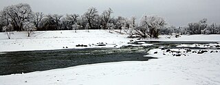
The 2009 Red River flood along the Red River of the North in North Dakota and Minnesota in the United States and Manitoba in Canada brought record flood levels to the Fargo-Moorhead area. The flood was a result of saturated and frozen ground, spring snowmelt exacerbated by additional rain and snow storms, and virtually flat terrain. Communities along the Red River prepared for more than a week as the U.S. National Weather Service continuously updated the predictions for the city of Fargo, North Dakota, with an increasingly higher projected river crest. Originally predicted to reach a level of near 43 feet (13 m) at Fargo by March 29, the river in fact crested at 40.84 feet (12.45 m) at 12:15 a.m. March 28, and started a slow decline. The river continued to rise to the north as the crest moved downstream.
The Old Settler's Pavilion near Pekin, North Dakota, in Stump Lake Park upon Stump Lake, was built in 1920. It has also been known as Stump Lake Park Pavilion.

