A cave or cavern is a natural void in the ground, specifically a space large enough for a human to enter. Caves often form by the weathering of rock and often extend deep underground. The word cave can also refer to much smaller openings such as sea caves, rock shelters, and grottos, though strictly speaking a cave is exogene, meaning it is deeper than its opening is wide, and a rock shelter is endogene.
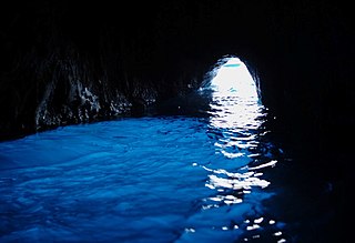
The Blue Grotto is a sea cave on the coast of the island of Capri, southern Italy. Sunlight, passing through an underwater cavity and shining through the seawater, creates a blue reflection that illuminates the cavern. The cave extends some 50 metres into the cliff at the surface, and is about 150 metres (490 ft) deep, with a sandy bottom.

A grotto is a natural or artificial cave used by humans in both modern times and antiquity, and historically or prehistorically. Naturally occurring grottoes are often small caves near water that are usually flooded or liable to flood at high tide. Sometimes, artificial grottoes are used as garden features. The Grotta Azzurra at Capri and the grotto at the villa of Tiberius in the Bay of Naples are examples of popular natural seashore grottoes.

The Longmen Grottoes or Longmen Caves are some of the finest examples of Chinese Buddhist art. Housing tens of thousands of statues of Buddha and his disciples, they are located 12 kilometres (7.5 mi) south of present-day Luoyang in Henan province, China. The images, many once painted, were carved as outside rock reliefs and inside artificial caves excavated from the limestone cliffs of the Xiangshan (香山) and Longmenshan, running east and west. The Yi River flows northward between them and the area used to be called Yique. The alternative name of "Dragon's Gate Grottoes" derives from the resemblance of the two hills that check the flow of the Yi River to the typical "Chinese gate towers" that once marked the entrance to Luoyang from the south. There are as many as 100,000 statues within the 2,345 caves, ranging from 1 inch (25 mm) to 57 feet (17 m) in height. The area also contains nearly 2,500 stelae and inscriptions, hence the name “Forest of Ancient Stelae", as well as over sixty Buddhist pagodas. Situated in a scenic natural environment, the caves were dug from a 1 kilometre (0.62 mi) stretch of cliff running along both banks of the river. 30% date from the Northern Wei and 60% from the Tang dynasty, caves from other periods accounting for less than 10% of the total. Starting with the Northern Wei Dynasty in 493 AD, patrons and donors included emperors, Wu Zetian, members of the royal family, other rich families, generals, and religious groups.

The Yungang Grottoes, formerly the Wuzhoushan Grottoes, are ancient Chinese Buddhist temple grottoes near the city of Datong in the province of Shanxi. They are excellent examples of rock-cut architecture and one of the three most famous ancient Buddhist sculptural sites of China. The others are Longmen and Mogao.

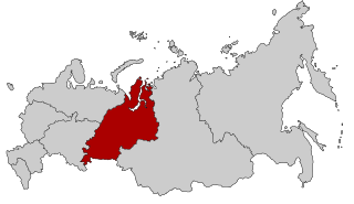
The Chusovaya River is a river flowing in Perm Krai, Sverdlovsk Oblast and Chelyabinsk Oblast of Russia. A tributary of the Kama River, which in turn is a tributary of the Volga River, it discharges into the Chusovskoy Cove of the Kamsky Reservoir. The river is remarkable in that it originates on the eastern slopes of the Ural Mountains in Asia, crosses the mountains, and mostly runs on their western slopes in Europe. The Chusovaya River is widely used as a source of water. In particular, its water is taken from the Volchikhinsky Reservoir, 37 square kilometres (14 sq mi), to the Verkhneisetsky Reservoir to supply the major city of Yekaterinburg. Fifteen smaller reservoirs are spread over about 150 tributaries of the river.

Kungur is a town in the southeast of Perm Krai, Russia, located in the Ural Mountains at the confluence of the Iren and Shakhva Rivers into the Sylva River. Population: 66,074 (2010 Census); 68,943 (2002 Census); 81,402 (1989 Census); 64,800 (1959); 36,000 (1939).

The Jeita Grotto is a system of two separate, but interconnected, karstic limestone caves spanning an overall length of nearly 9 kilometres (5.6 mi). The caves are situated in the Nahr al-Kalb valley within the locality of Jeita, 18 kilometres (11 mi) north of the Lebanese capital Beirut. Though inhabited in prehistoric times, the lower cave was not rediscovered until 1836 by Reverend William Thomson; it can only be visited by boat since it channels an underground river that provides fresh drinking water to more than a million Lebanese.
Sakmara River is a river in Russia that drains the southern tip of the Ural Mountains south into the Ural River. It is 760 kilometres (470 mi) long. It is a tributary of the Ural River, which it meets in Orenburg. The source of the Sakmara River is in the Republic of Bashkortostan. Other towns along the Sakmara are Yuldybayevo (Bashkortostan), Kuvandyk, and railway station Saraktash clouse to the Wozdwizhenskaya Fortress.
For the defunct "Ural Automobiles and Motors" see Amur (company)

Imienko is a settlement in the administrative district of Gmina Połczyn-Zdrój, within Świdwin County, West Pomeranian Voivodeship, in north-western Poland. It lies approximately 11 kilometres (7 mi) south-west of Połczyn-Zdrój, 15 km (9 mi) south-east of Świdwin, and 97 km (60 mi) east of the regional capital Szczecin.
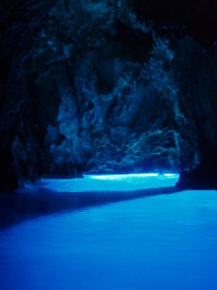
The Blue Grotto or Blue Cave, is a waterlogged sea cave located in a small bay called Balun, on the east side of the island of Biševo and about 4.5 nautical miles (8.3 km) from Komiža, in the Croatian Adriatic. It is situated in the central Dalmatian archipelago, 5 km south-west of the island of Vis. The grotto is one of the best known natural beauty spots on the Adriatic and a popular show cave because of the glowing blue light that appears at certain times of day.
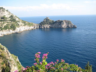
The Grotta dello Smeraldo is a cave, partly inundated by the sea and located in Conca dei Marini, Italy, on the Amalfi Coast.
Quri Qale Cave or QuraQala is a cave located northwest of Ravansar, Iran, and is one of the longest caves in western Asia. First explored in the 1950s, in 1989 it was further opened by an Iranian team. It contains three main chambers, with calcite crystals, stalactites and waterfalls. It is known for its colony of mouse ear bats, and for a number of archaeological finds, including silver plates dating the late Sassanian period.

Les Grottes Pétrifiantes de Savonnières, also known as the caves gouttières, are two grottoes located in Savonnières, Indre-et-Loire, France.

Kurgazak Cave is a cave in the Ural Mountains, in the Ay River valley. Located in the Chelyabinsk oblast, Russia, and between the villages Mezhevoy Alexeevka is a natural monument. The first mention of the cave belongs to the second half of the 18th century, when it was described by Peter Simon Pallas academician.

Kapova cave is a limestone karst cave in the Burzyansky District of Bashkortostan, Russia, ca. 200 km (120 mi) south-east of Ufa, in the southern Ural mountains. Located on the Belaya River in the natural reserve Shulgan-Tash, the cave is best known for the 16,000 years old Upper Paleolithic rock paintings and drawings.

Bashkiriya National Park, covers a large contiguous forest on the southern end of the Ural Mountains. The park is an important buffer between the industrialized flatlands to the west, and the mountainous and sparsely-populated Shulgan-Tash nature reserve and Altyn-Solok entomological reserve to the east and north. Bashkirya National Park lies between the Nugush River, and the southern bend of the Belaya River. The park features deep river valley cuts in a karst topography. It is known for a natural bridge across the river Kuperlya. The park is situated across three districts of the Republic of Bashkortostan.

The Pair-non-Pair Cave is located near the village of Prignac-et-Marcamps, Aquitaine:Gironde (33) department in France. Only discovered in 1881 it is known for remarkable prehistoric parietal engravings - petroglyphic representations of wild animals, "which rank among the most ancient examples of art made by prehistoric" humans, dating back to between 30.000 and 25.000 BP, the Aurignacian cultural period of the Upper Paleolithic.