Notes
- ↑ "Sukleji Dam Project". WAPDA, Govt of Pakistan. Retrieved 6 July 2012.
28°47′N67°24′E / 28.783°N 67.400°E
| | This Balochistan location article is a stub. You can help Wikipedia by expanding it. |
Sukleji River is a river in Balochistan Province, in southwestern Pakistan.
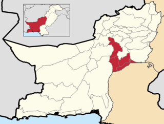
Sukleji Dam is a proposed dam located across Sukleji River in the Kachhi District of Balochistan. [1]
28°47′N67°24′E / 28.783°N 67.400°E
| | This Balochistan location article is a stub. You can help Wikipedia by expanding it. |
Shadi Kaur Dam is a dam located on the Shadi Kaur river about 50 kilometres north of Pasni in Balochistan province of Pakistan. The dam, 485 metres long, was constructed in 2003 at a cost of 45 million Pakistani rupees ($758,853) to provide irrigation for nearby farms.
Bibi Nani is an area in the road between the towns of Quetta and Sibi, in Balochistan, Pakistan, and is located at 29°41'60N 67°22'60E. The area name is most probably derived from a Sufi figure that was buried in its suburbs and is also the location of a Hindu shrine.

Hub Dam is a reservoir on the Hub River. It is situated 56 km from Karachi city in Karachi and Hub District on Sindh and Balochistan provinces border. The dam is extended to 24300 acres with gross storage capacity of 857000 acre feet. It is Pakistan's fifth-largest dam. It is an important source that provides the drinking water to the metropolitan city Karachi.

The Gomal is a 400-kilometre-long (250 mi) river in Afghanistan and Pakistan. It rises in northern Afghanistan's Paktika Province and joins the Indus River 20 miles south of Dera Ismail Khan, in Pakistan's Khyber Pakhtunkhwa province.
Naseerabad Division is an administrative division of Balochistan Province, Pakistan. It is the only Irrigation & Agricultural Division of Balochistan. The division connects Balochistan with Sindh. Naseerabad division was created by bifurcation of Sibi division in 1987. Its Divisional headquarters are at Dera Murad Jamali. CNIC Code of Naseerabad Division is 53. According to 2023 Pakistani census population of Nasirabad Division is 2,044,021.
Hub District, is a coastal administrative district and located at southern part of Balochistan Province of Pakistan. The district was created after bifurcation of Lasbela District in 2022.
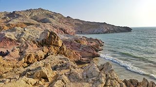
The Kech River flows in the Makran region of southeastern Iran and the southwestern area of Balochistan Province in southwestern Pakistan.
Mula River is located in Balochistan, Pakistan. It is located at an elevation of 45 meters above sea level.
Sibi Junction railway station is located in Sibi, Balochistan, Pakistan. It is staffed and has a booking office. The station served as the junction between the Rohri-Chaman Railway Line and Kandahar State Railway.
Koh-i-Takatu is a Mount peak located in the Sulaiman Mountains range, in the North east of Quetta District of Balochistan Province, in western Pakistan.

The topography of Pakistan is divided into seven geographic areas: the northern highlands, the Indus River plain, the desert areas, the Pothohar Plateau, Balochistan Plateau, Salt Range, and the Sistan Basin. All the rivers of Pakistan, i.e. Sindh, Ravi River, Chenab River, Jhelum River, and Sutlej River, originate from the Himalayas mountain range. Some geographers designate Plateau as to the west of the imaginary southwest line; and the Indus Plain lies to the east of that line.
Hingol Dam is a proposed small, low-head, Central Core Zone, hydroelectric power generation dam of 3.5 megawatt (MW) generation capacity, located in the Lasbela District across the Hingol River in the Balochistan province of Pakistan. It is located at a distance of 260 km (162 mi) northwest of Karachi and about 16 km (10 mi) north of bridge across the Hingol River on the Makran Coastal Highway and about 8 km (5 mi) north of Kund Malir where the river falls into the sea.
Damboli Railway Station is located in Damboli village, Kachhi district of Balochistan province, Pakistan.
Dingra Railway Station is located in Dingra village, Kachhi district of Balochistan province, Pakistan.
Hirok Railway Station is located in Hirok village, Kachhi district of Balochistan province of the Pakistan.
Mushkaf Railway Station is located in Mushkaf village, Kachhi district of Balochistan province, Pakistan.
Muslimbagh Railway Station, previously known as Hindubagh railway station, is located in town of Muslim Bagh, Killa Saifullah District, Balochistan, Pakistan.
Peshi Railway Station is located in Peshi village, Kachhi district of Balochistan province, Pakistan.