Related Research Articles
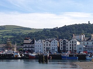
Ramsey is a coastal town in the north of the Isle of Man. It is the second largest town on the island after Douglas. Its population is 7,845 according to the 2016 Census. It has one of the biggest harbours on the island, and has a prominent derelict pier, called the Queen's Pier. It was formerly one of the main points of communication with Scotland. Ramsey has also been a route for several invasions by the Vikings and Scots.

The Isle of Man Railway (IMR) is a narrow gauge steam-operated railway connecting Douglas with Castletown and Port Erin on the Isle of Man. The line is 3 ft narrow gauge and 15+1⁄2 miles long. It is the remainder of what was a much larger network that also served the western town of Peel, the northern town of Ramsey and the small mining village of Foxdale. Now in government ownership, it uses original rolling stock and locomotives and there are few concessions to modernity.
St John's is a small village in the sheading of Glenfaba in the Isle of Man, in the island's central valley. It is in the House of Keys constituency of Glenfaba & Peel, which elects two MHKs.
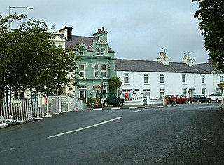
Ballaugh is a small village on the Isle of Man in the parish of the same name, in the sheading of Michael. It is the only village in the parish.
The Manx Northern Railway (MNR) was the second common carrier railway built in the Isle of Man. It operated as an independent concern only from 1879 to 1905.

Sulby is a village in the Isle of Man. It is 4 miles from Ramsey and is located in the parish of Kirk Christ Lezayre on the A3 Castletown road.
The Foxdale Railway was a 3 ft narrow gauge branch line which ran from St. John's to Foxdale on the Isle of Man.
This article details each of the lines operated by the Isle of Man Railway, including the original line to Peel in the west, opened in 1873, followed by the Port Erin line the following year, as well as the Manx Northern Railway's line between St John's and Ramsey and the Foxdale Railway's line between St John's and Foxdale.

Peel Road Railway Station was a station on the Manx Northern Railway, later owned and operated by the Isle of Man Railway. It served the area known as Poortown in the Isle of Man and was an intermediate stopping place on a line that ran between St. John's and Ramsey.

Kirk Michael Railway Station was an intermediate station on the Manx Northern Railway (MNR), which ran between St. John's and Ramsey in the Isle of Man, later owned and operated by the Isle of Man Railway. It served the village of Kirk Michael.

St John's Railway Station was on the Isle of Man Railway (IMR), later merging with the nearby station of the Manx Northern Railway (MNR); it was the junction of lines to Douglas, Peel, Ramsey and Foxdale. It was close to Tynwald Hill.

Ramsey Station was a station on the Manx Northern Railway, later owned and operated by the Isle of Man Railway; it served the town of Ramsey in the Isle of Man, and was the terminus of a line that ran between St. John's and this station, which was the railway's headquarters.
Ballaugh Station was a mandatory stopping place on the Manx Northern Railway that ran between St. John's and Ramsey in the Isle of Man. It opened when the line was opened and was later owned and operated by the Isle of Man Railway; it served the village of Ballaugh.

Sulby Glen Railway Station was a station on the Manx Northern Railway, later owned and operated by the Isle of Man Railway; it served the village of Sulby in the Isle of Man and was an intermediate stopping place on a line that ran between St. John's and Ramsey.

St Germain'sRailway Station was a station on the Manx Northern Railway in the Isle of Man, later owned and operated by the Isle of Man Railway; it served the small village of the same name and was an intermediate stopping place on a line that ran between St John's and Ramsey.

Lezayre Railway Station was an intermediate stopping place on the Manx Northern Railway, a line that ran between St. John's and Ramsey in the Isle of Man. It was the first halt outside the terminus at Ramsey. It was later owned and operated by the Isle of Man Railway. It served the small village known as Churchtown centred on the parish church, Kirk Christ Lezayre.

Bishop's Court Halt was a station on the Manx Northern Railway, later owned and operated by the Isle of Man Railway; it served the residence of the local bishop in the Isle of Man and was a stopping place on a line that ran between St. John's and Ramsey.

West BerkRailway Station was a station on the Manx Northern Railway, later owned and operated by the Isle of Man Railway; it served a small area near Kirk Michael in the Isle of Man and was an intermediate stopping place on a line that ran between St. John's and Ramsey.
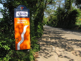
Quarry Bends is situated adjacent to the 20th Milestone road-side marker on the primary A3 Castletown to Ramsey, in the parishes of Ballaugh and Kirk Christ Lezayre in the Isle of Man.

Douglas Road Corner or Kirk Michael Corner is situated adjacent the 14th Milestone road-side marker on the Snaefell Mountain Course on the primary A3 Castletown to Ramsey Road and the road junction with the A4 Peel to Kirk Michael Coast Road in the parish of Michael in the Isle of Man.
References
- "Sulby Bridge station at the Subterranea Britannica Disused Stations website".
- Heavyside, Tom (August 2004). Narrow Gauge Branch Lines – Douglas to Ramsey. Middleton Press. ISBN 1-904474-39-X.