Related Research Articles

Holland is a neighborhood in the Northeast community in Minneapolis. It is one of ten neighborhoods in Ward 1 of Minneapolis, currently represented by Council President Elliott Payne.

Lowry Hill is a neighborhood within the Calhoun-Isles community in Minneapolis, Minnesota. The neighborhood is regarded as being one of the city’s most upscale and wealthy neighborhoods. It was historically the home of Minneapolis’s most prominent milling and lumber families.

Lowry Hill East, also known as the Wedge because of its wedge-like shape, is a neighborhood in southwest Minneapolis, Minnesota, United States, part of the Calhoun Isles community. It is bounded on the east by Lyndale Avenue, on the west by Hennepin Avenue and on the south by Lake Street. Lyndale and Hennepin intersect on the northern side at Interstate 94. This creates a neighborhood roughly triangular in shape.

South Uptown is a residential neighborhood in the Calhoun Isles community of Minneapolis, Minnesota.
Armatage is a neighborhood in the Southwest community in Minneapolis. In the city's southwest corner, the neighborhood is bounded on the north by 54th Street West, on the east by Logan Avenue South, on the south by Highway 62, and on the west by the city limits at Xerxes Avenue South. Armatage is a part of Ward 13, currently represented by Minneapolis City Council member Linea Palmisano.

Hale is a neighborhood near the southern edge of Minneapolis. It lies south of Minnehaha Creek, north of 55th Street, east of Chicago Avenue, and west of Cedar Avenue. It is a part of Ward 11, currently represented by city council member Emily Koski.

Stadium Village is an area of Minneapolis, Minnesota near the East Bank campus of the University of Minnesota. While not an official neighborhood of Minneapolis, the area is an important commercial district that serves university students with many bars and restaurants. There are plans to incorporate it into an official neighborhood of Minneapolis along with the surrounding area. It is part of Southeast Minneapolis, that part of Minneapolis on the East Bank of the Mississippi River and south of Hennepin Avenue

Downtown East is an official neighborhood in Minneapolis, Minnesota, United States. It is in Ward 3, currently represented by council member Michael Rainville.

Como is a neighborhood within the Southeast quadrant of Minneapolis. The neighborhood is also sometimes referred to as Southeast Como to help differentiate it from the Como Park neighborhood in neighboring Saint Paul. Its boundaries are East Hennepin Avenue to the north, 33rd Avenue Southeast to the east, the Southeast Industrial Area to the south, and Interstate 35W to the west. Como is also part of the University District in Minneapolis, with its location near the main Minneapolis campus of the University of Minnesota.

Fulton is a neighborhood in the Southwest community in Minneapolis. Its boundaries are West 47th Street to the north, Penn Avenue South to the east, West 54th Street to the south, and France Avenue South to the west. Fulton is a part of Ward 13, currently represented by Minneapolis City Council member Linea Palmisano.

Saint Anthony Park is a neighborhood in northwest Saint Paul, Minnesota. It is adjacent to the University of Minnesota's St. Paul Campus, bordering Prospect Park, Minneapolis on the west, the Minnesota State Fairgrounds on the east, and the suburbs of Falcon Heights and Lauderdale to the north.

Lyn-Lake is a commercial district in Minneapolis centered at the intersection of West Lake Street and Lyndale Avenue from which it takes its name. The street intersection is the boundary for four official neighborhoods: Whittier on the northeast, Lyndale on the southeast, South Uptown on the southwest, and Lowry Hill East on the northwest. The Lyn-Lake Business Association branded the unofficial commercial district as "Lyn-Lake" in 1999.
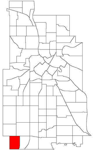
Wenonah is a neighborhood on the southeast side of Minneapolis, Minnesota. Its boundaries are 54th Street to the north, 34th Avenue to the east, the Minneapolis-Saint Paul International Airport to the south, and Cedar Avenue to the west. The neighborhood contains a portion of Lake Nokomis.

Summit Avenue is a street in St. Paul, Minnesota, United States, known for being the longest avenue of Victorian homes in the country, having a number of historic houses, churches, synagogues, and schools. The street starts just west of downtown St. Paul and continues four and a half miles west to the Mississippi River where Saint Paul meets Minneapolis. Other cities have similar streets, such as Prairie Avenue in Chicago, Euclid Avenue in Cleveland, and Fifth Avenue in New York City. Summit Avenue is notable for having preserved its historic character and mix of buildings, as compared to these other examples. Historian Ernest R. Sandeen described Summit Avenue as "the best preserved example of the Victorian monumental residential boulevard."

Saint Paul, Minnesota, consists of 17 officially defined city districts or neighborhoods.
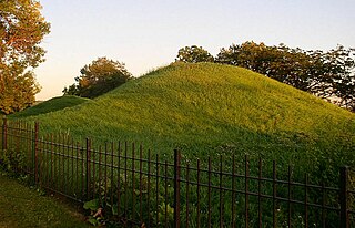
Dayton's Bluff is a neighborhood located on the east side of the Mississippi River in the southeast part of the city of Saint Paul, Minnesota which has a large residential district on the plateau extending backward from its top. The name of the bluff commemorates Lyman Dayton, for whom a city in Hennepin County was also named. On the edge of the southern and highest part of Dayton's Bluff, in Indian Mounds Park, is a series of seven large aboriginal mounds, 4 to 18 feet high, that overlook the river and the central part of the city.

Downtown Saint Paul is the central business district of Saint Paul, Minnesota, United States. Its boundaries are the Mississippi River to the south, University Avenue to the north, US 52 to the east, and Kellogg Boulevard to the west. It is bounded by the Dayton's Bluff, Summit-University, West Seventh, Frogtown, West Side, and Payne-Phalen neighborhoods. The West Side neighborhood is on the other side of the river, and can be accessed via the Robert Street Bridge or the Wabasha Street Bridge. Interstate 35E and Interstate 94 run through the north side of the neighborhood, providing a separation between the Minnesota State Capitol and other state government buildings with the rest of downtown.

West Seventh is a neighborhood and city district in Saint Paul, Minnesota. It comprises three smaller neighborhoods: from west to east, the West End, Uppertown, and Irvine Park. The neighborhood lies at the base of Summit Hill and along the Mississippi River's western bluffs, spanning the entire length of West 7th Street. It is also known as Old Fort Road and the Fort Road area. The street follows a historic Native American and fur trader path along the river from downtown Saint Paul to Fort Snelling.

Selby Avenue is a street in Saint Paul, Minnesota, United States, that runs east–west from Summit Avenue near downtown toward the Mississippi River. The street runs through the Summit-University and Union Park neighborhoods. The street, especially between Dale Street and Snelling Avenue, has been associated with Saint Paul's black community. The far eastern end of the street has historically been more densely developed and architecturally significant.

Union Park is a neighborhood in Saint Paul in the U.S. state of Minnesota. Created as a merger of several historic neighborhoods including Merriam Park, Snelling-Hamline, Parts of Midway, Densoyer Park, and Lexington-Hamline, it is bordered by University Avenue on the north, Lexington Parkway on the east, Summit Avenue on the south, and the Mississippi National River and Recreation Area on the west. Despite the merger, many of the historic neighborhoods hold onto their original identity, especially in Lexington-Hamline and Merriam Park.
References
- ↑ Summit Hill Community Plan Retrieved on February 2nd, 2024
- ↑ Palmer, Kim. "Exploring the architecture and history of St. Paul's Summit Hill." Minnesota Star Tribune, 4 October 2018. Retrieved 8 August 2024
- ↑ History of the Minnesota Governor's Residence Retrieved 8 September 2024
- ↑ Guide to Grand Old Day Retrieved 8 September 2024