Related Research Articles

Santa Cruz is a town in Saint Elizabeth, Jamaica, on the A2 road connecting Black River to Mandeville. A minor market village until the 1950s, the development of nearby areas for bauxite mining stimulated its growth in the 1950s and 1960s, as did the establishment of the St. Elizabeth Technical High School in 1961. Santa Cruz has its own courthouse, police station and a wide variety of restaurants alongside supermarkets and funeral parlors.

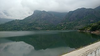
The Anamala or Anaimalai, also known as the Elephant Mountains, are a range of mountains in the southern Western Ghats of central Kerala and span the border of western Tamil Nadu in Southern India. The name anamala is derived from the Malayalam word aana and the Tamil word yaanai, meaning elephant, or from tribal languages. Mala or Malai means 'mountain', and thus literally translatable as 'Elephant mountain'.
Burghclere is a village and civil parish in Hampshire, England. According to the 2011 census the village had a population of 1,152. The village is near the border of Hampshire with Berkshire, four miles south of Newbury. It is also very close to Newtown and Old Burghclere.

Baena is a town and municipality of Spain located in the province of Córdoba, Andalusia. It is situated near the river Marbella on the slope of a hill 52 kilometres (32 mi) southeast of Córdoba by road. The population of the town is 20,266 (2012).
Pollachi is a town and a taluk headquarters in Coimbatore district, Tamil Nadu state, India. Located about 40 km (25 mi) to the south of Coimbatore, it is the second largest town in the district after Coimbatore. Pollachi is a popular marketplace for jaggery, vegetables and cattle. As of 2011, the town had a population of 90,180. Another name for Pollachi is "Mother of Nature".

Kufri is a resort hill station in the district of Shimla, India. It is located 20 km (12 mi) from the state capital Shimla on the National Highway No. 22. On the Kufri Avenue, the main thoroughfare, boutiques and restaurants mix with Indian-style hotels and souvenir shops are to look for during a visit.

The Asan Barrage is a barrage in the Uttarakhand-Himachal Pradesh border region in Doon Valley,, northern India, situated at the confluence of the Eastern Yamuna Canal and the Asan River and about 11 km (7 mi) from Dakpathar, and 28 km. northwest of Dehradun in Uttarakhand. The barrage is 287.5m long and has water throughout the year which is fed from the river Asan and the discharge channel of the river Yamuna. Since 2020 it has been declared as Uttarakhand's first Ramsar site.

Rampur Bushahr is a town and a municipal council in Shimla district in the Indian state of Himachal Pradesh. It is about 130 km from Shimla and is well connected with NH 5 which passes through Theog, Narkanda and Kumarsain.

Merapoh is a small town in Lipis District, Pahang, Malaysia. It is located next to the Pahang-Kelantan border. A railway station of the KTM East Coast Line is located here.
Kodai road is a railway station in Tamil Nadu state, India, lying between Dindigul and Madurai at 10°10′45″N77°54′34″E. It is formally listed as Kodaikanal Road.

Dome Fuji, also called Dome F or Valkyrie Dome, is an Antarctic base located in the eastern part of Queen Maud Land at 77°30′S37°30′E. With an altitude of 3,810 metres (12,500 ft) above sea level, it is the second-highest summit or ice dome of the East Antarctic Ice Sheet and represents an ice divide. Dome F is the site of Dome Fuji Station, a research station operated by Japan.

Alikadam is an upazila of Bandarban District in the Division of Chittagong, Bangladesh.

Washington Air Route Traffic Control Center (ZDC) is an Area Control Center operated by the Federal Aviation Administration and located at Lawson Rd SE, Leesburg, Virginia, United States. The primary responsibility of ZDC is the separation of airplane flights and the expedited sequencing of arrivals and departures along STARs and SIDs for the Washington-Baltimore Metropolitan Area, the New York Metropolitan Area, and Philadelphia among many other areas.
Villanueva de Carazo is a municipality located in the province of Burgos, Castile and León, Spain. According to the 2004 census (INE), the municipality has a population of 30 inhabitants.
Nobsin is a town in the Mogtédo Department of Ganzourgou Province in central Burkina Faso. The town has a population of 1,998.

The Kodaikanal–Munnar Road was located in Dindigul District and Theni District of Tamil Nadu and Idukki district of Kerala in South India. It covers 81 kilometers (50 mi) from Kodaikanal to Munnar. The road was improved by the British in 1942 as an evacuation route in preparation for a possible Japanese invasion of South India. With a maximum elevation of 2,480 meters (8,140 ft) just south of Vandaravu Peak, it was among the highest roads in India, south of the Himalayas, prior to its closure in 1990.
Bommasamudra is a village in Dharwad district of Karnataka, India.

Kukri Hills is a prominent east-west trending range, about 25 nautical miles (46 km) long and over 2,000 metres (6,600 ft) high, forming the divide between Ferrar Glacier on the south and Taylor Glacier and Taylor Valley on the north, in Victoria Land, Antarctica.
Dandoh is a village in the Hoshiarpur tehsil, Hoshiarpur district of Punjab, India. It is one of 415 villages in Hoshiarpur. the closest railway station to Dandoh is Hoshiarpur railway station. The village is situated about 134.5 km from Chandigarh, the state capital.
References
31°19′N77°42′E / 31.317°N 77.700°E
| | This Himachal Pradesh location article is a stub. You can help Wikipedia by expanding it. |