Sunnyslope, Salem, Oregon

Last updated
Snow at a Sunnyslope apartment complex Sunnyslope salem oregon snow.jpg
Snow at a Sunnyslope apartment complex

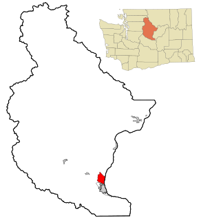
Sunnyslope [1] is a primarily residential neighborhood in Salem, Oregon, United States located in the far southwest part of the city. The neighborhood is bordered on the north by Browning Avenue, and on the east with Liberty Road. Sunnyslope is home to Sprague High School.

Salem, Oregon State capital city in Oregon, United States

Salem is the capital of the U.S. state of Oregon, and the county seat of Marion County. It is located in the center of the Willamette Valley alongside the Willamette River, which runs north through the city. The river forms the boundary between Marion and Polk counties, and the city neighborhood of West Salem is in Polk County. Salem was founded in 1842, became the capital of the Oregon Territory in 1851, and was incorporated in 1857.

Oregon State of the United States of America

Oregon is a state in the Pacific Northwest region on the West Coast of the United States. The Columbia River delineates much of Oregon's northern boundary with Washington, while the Snake River delineates much of its eastern boundary with Idaho. The parallel 42° north delineates the southern boundary with California and Nevada. Oregon is one of only three states of the contiguous United States to have a coastline on the Pacific Ocean.

United States federal republic in North America

The United States of America (USA), commonly known as the United States or America, is a country composed of 50 states, a federal district, five major self-governing territories, and various possessions. At 3.8 million square miles, the United States is the world's third or fourth largest country by total area and is slightly smaller than the entire continent of Europe's 3.9 million square miles. With a population of over 327 million people, the U.S. is the third most populous country. The capital is Washington, D.C., and the largest city by population is New York City. Forty-eight states and the capital's federal district are contiguous in North America between Canada and Mexico. The State of Alaska is in the northwest corner of North America, bordered by Canada to the east and across the Bering Strait from Russia to the west. The State of Hawaii is an archipelago in the mid-Pacific Ocean. The U.S. territories are scattered about the Pacific Ocean and the Caribbean Sea, stretching across nine official time zones. The extremely diverse geography, climate, and wildlife of the United States make it one of the world's 17 megadiverse countries.

Coordinates: 44°53′10″N123°04′12″W / 44.886°N 123.070°W / 44.886; -123.070

Geographic coordinate system Coordinate system

A geographic coordinate system is a coordinate system that enables every location on Earth to be specified by a set of numbers, letters or symbols. The coordinates are often chosen such that one of the numbers represents a vertical position and two or three of the numbers represent a horizontal position; alternatively, a geographic position may be expressed in a combined three-dimensional Cartesian vector. A common choice of coordinates is latitude, longitude and elevation. To specify a location on a plane requires a map projection.

Related Research Articles

Sunnyslope, California Former census-designated place in California, United States

Sunnyslope was a census-designated place (CDP) in Riverside County, California, United States. The population was 5,153 at the 2010 census, up from 4,437 at the 2000 census. On July 1, 2011, the CDP became part of the newly incorporated City of Jurupa Valley.

Sheffield, Pennsylvania Census-designated place in Pennsylvania, United States

Sheffield is a census-designated place (CDP) in Warren County, Pennsylvania, United States. The population was 1,123 at the 2010 census.

Sunnyslope, Washington Census-designated place in Washington, United States

Sunnyslope is an unincorporated community and census-designated place (CDP) in Chelan County, Washington, United States. It is part of the Wenatchee–East Wenatchee Metropolitan Statistical Area. The population was 3,252 at the 2010 census, up from 2,521 at the 2000 census.

Glendale Union High School District No. 205 is a school district headquartered in Glendale, Arizona, United States.

SS Pedernales was a lake tanker of the World War II and post war eras. She was built in 1938 in Monfalcone, Italy, and sailed under the British flag. Pedernales was severely damaged in a torpedo attack on 16 February 1942 while anchored at Aruba.

South Central is a neighborhood in Salem, Oregon, United States, located just south of downtown. Major neighborhood features include Bush's Pasture Park, the Asahel Bush House and Museum, Deepwood Estate, Gaiety Hill-Bush's Pasture Park Historic District, South Salem High School, and Mahonia Hall, the official residence of the Governor of Oregon.

WRFW is a Class A radio station licensed to the UW System Board of Regents and operates in River Falls, Wisconsin. WRFW is an affiliate of Wisconsin Public Radio (WPR), and airs news and talk programming from WPR's "Ideas Network". The station also broadcasts local news, sports information, and entertainment programming. The broadcast studios are located in North Hall on the University of Wisconsin-River Falls campus.

Sunnyslope, Alberta

Sunnyslope is a hamlet in southern Alberta, Canada within Kneehill County. It is located on Highway 582, approximately 21 kilometres (13 mi) southwest of Three Hills and 40 kilometres (25 mi) east of Didsbury. The first post office was opened in 1903.

Daisy-Villa is a neighborhood in Pasadena, California. It is bordered by Sierra Madre Boulevard to the west, Orange Grove Boulevard to the north, the 210 Freeway to the south, and the Eaton Wash to the east. Daisy-Villa is an exclusively residential neighborhood with approximately 350 homes. The neighborhood is named after two streets that meet in the center of the community.

Sunnyslope, Butte County, California Unincorporated community in California, United States

Sunnyslope is an unincorporated community in Butte County, California. It lies at an elevation of 548 feet.

The Alder River is a 6.3-mile-long (10.1 km) river in Maine. A tributary of the Androscoggin River, the Alder flows west from Locke Mills to Bethel.

Del Mar Landing State Marine Reserve marine reserve in California

Del Mar Landing State Marine Reserve (SMR) is a marine protected area that lies onshore, about two miles south of the town of Gualala and three and a half miles north of Sea Ranch in Sonoma County on California’s north central coast. The marine protected area covers 0.22 square miles (0.57 km2). Del Mar Landing SMR prohibits the take of all living marine resources.

Friendly, Eugene, Oregon human settlement in the United States of America

Friendly is a neighborhood in south central Eugene, Oregon, United States. It is represented by the neighborhood association Friendly Area Neighbors.

Sunnyslope, Phoenix Populated place

The Sunnyslope community is an established neighborhood within the borders of the city of Phoenix, Arizona. The geographic boundaries are 19th Avenue to the west, Cactus Road to the north, 16th Street to the east, and Northern Avenue to the south. This area covers approximately nine square miles and is divided into nine census tracts. The Sunnyslope community is included in parts of three zip code areas: 85020, 85021 and 85029.

Bethel-Danebo, most commonly referred to as Bethel, is a neighborhood of west Eugene, Oregon, United States. The neighborhood boundaries are Oregon Route 99 on the east, the former Southern Pacific Coos Bay Line on the south, Green Hill Road on the west and Clear Lake Road on the north.

Jefferson Westside is a neighborhood in Eugene, Oregon, United States.

Plaza Venezuela neighborhood of Caracas

Plaza Venezuela is a public square located in Los Caobos neighborhood, Caracas, Venezuela. It was inaugurated in 1940 and is situated in the geographic center of Caracas.

El Cid Castle Place

El Cid Castle was a landmark structure located on the opposite side of the western boundary of Sunnyslope, Arizona. The controversial castle, built by the late Dr. Kenneth Hall, was supposed to be a bowling alley which resembled a Moorish Castle. Construction on the structure began in 1963 and was completed in 1980.

There are 21 mountain peaks named West Peak in the United States according to the US Geological Survey Geographic Names Information System.

Faye Wright is a neighborhood in Salem, Oregon, United States, located in the southeast part of the city.The neighborhood is bordered on the east by Commercial Street SE, on the west by Liberty Road S, and on the south by Kuebler Boulevard SE.

References

  1. Exact boundary of Sunnyslope (OpenStreetMap)