

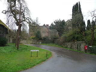
Sunset is a locality immediately to the east of the town of Kington, Herefordshire in England.
Contents
It is bordered by the River Arrow.
Sunset is a locality immediately to the east of the town of Kington, Herefordshire in England.
It is bordered by the River Arrow.
Richard Meredith acquired Thomas Miles' iron business through marriage to Miles' daughter Elizabeth in 1739 and expanded it across Kington in the following decades. His nephew John Meredith inherited the business and subsequently built a new iron foundry facility at Sunset in 1820. Resources were transported via tramway. John Meredith's three sons developed workers' housing at Nail Row in 1826. The business was passed down to their sons and became Kington's largest employer by the 1880s. After being sold in 1901, the foundry closed in 1927. [1]

Offa's Dyke Path is a long-distance footpath loosely following the Wales–England border. Officially opened on 10 July 1971, by Lord Hunt, it is one of Britain's National Trails and draws walkers from throughout the world. About 60 miles (97 km) of the 177-mile (285 km) route either follows, or keeps close company with, the remnants of Offa's Dyke, an earthwork traditionally thought to have been constructed in the late 8th century on the orders of King Offa of Mercia.

The A44 is a major road in the United Kingdom that runs from Oxford in southern England to Aberystwyth in west Wales.

Kington is a market town and civil parish in Herefordshire, England. The parish had a population of 3,240.

The Leominster Canal was an English canal which ran for just over 18 miles from Mamble to Leominster through 16 locks and a number of tunnels, some of which suffered engineering problems even before the canal opened. Originally, the canal was part of a much more ambitious plan to run 46 miles from Stourport to Kington.

Leominster was a parliamentary constituency represented until 1707 in the House of Commons of England, then until 1801 in that of Great Britain, and finally until 2010, when it disappeared in boundary changes, in the Parliament of the United Kingdom.

North Herefordshire is a constituency represented in the House of Commons of the UK Parliament since 2024 by Ellie Chowns of the Green Party of England and Wales. It is the first Green seat in the West Midlands region.

Huntington Castle was situated in the village of Huntington in Herefordshire, England, 2+1⁄2 miles south-west of Kington.
Kington Castle stood in the medieval market town of Kington in Herefordshire, England. It was built in the 11th century and destroyed in 1215.
Kington Town Football Club is a football club based in Kington, Herefordshire, England. They are currently members of the Herefordshire League Premier Division and play at Mill Street.
Titley is a village and civil parish in Herefordshire, England. It lies on the B4355 between Kington and Presteigne.
The Kington Tramway was an early narrow gauge horse-drawn tramway that linked limestone quarries at Burlinjobb near New Radnor in Radnorshire, Wales, to Eardisley in Herefordshire, England.
New Radnor was, from 1894 to 1974, a rural district in the administrative county of Radnorshire, Wales.
Rushock is a small village in Herefordshire, England. It lies about 1 mile north-east of Kington. The population of the civil parish was 131 at the 2011 census.
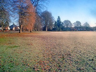
The Recreation Ground is a cricket ground in Kington, Herefordshire. In 1996, Herefordshire played Wales Minor Counties in the grounds first Minor Counties Championship match. From 1996 to present, the ground has hosted 6 Minor Counties Championship matches and 3 MCCA Knockout Trophy matches.
Cascob (Welsh: Casgob) is a small village in Powys. It is located in a valley five miles to the south-west of Knighton. The village is part of Whitton, Powys. The village is situated to the east of Radnor Forest, an area of moorland just within Wales. It also lies to the north-west of the small border town of Kington.

High Vinnalls is a hill in the English county of Herefordshire, though commonly considered a member of the Shropshire Hills. It is located in the parish of Pipe Aston, near the town of Ludlow, and is covered by Mortimer Forest.

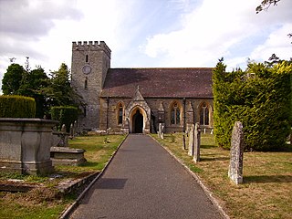
The Church of St Mary, or St. Mary the Virgin Church, Kington, Herefordshire, England is a Grade I listed parish church.
Rodd, Nash and Little Brampton is a civil parish in the county of Herefordshire, England, and is 18 miles (29 km) north-west from the city and county town of Hereford. The parish borders Powys in Wales at its north-west. Within the parish is the final home and studio of the 20th-century Australian artist Sydney Nolan.
Staunton on Arrow is a village and civil parish in the county of Herefordshire, England. The village is 17 miles (27 km) north-west of Hereford and 8 miles (13 km) to the west of Leominster. Within the parish is the site of the Iron Age hill fort of Wapley Hill.
Kington Rural is a civil parish in west Herefordshire, England, and is approximately 17 miles (30 km) north-west from the city and county town of Hereford. The parish borders Wales at the west, and contains the hamlets and small settlements of Upper Hergest, Lower Hergest, Chickward, Bredward, and Kingswood at the south, and Bradnor Green and Rushok at the north. The nearest town is the market town of Kington which, with its parish, is to a large extent enclosed by Kington Rural. Significant landmarks of the parish are the Castle Twts motte and bailey earthwork, Hergest Court 15th-century manor house, and Hergest Ridge on the England–Wales border.
52°12′21″N3°01′06″W / 52.20592°N 3.01845°W
| | This Herefordshire location article is a stub. You can help Wikipedia by expanding it. |