
Windermere is a residential neighborhood in northeastern Seattle, Washington, named after Windermere in England's Lake District. It is bounded on the north by Magnuson Park, part of Sand Point; on the northwest by Sand Point Way N.E., beyond which is Hawthorne Hills; on the southwest by Ivanhoe Place N.E., beyond which is Laurelhurst; and on the southeast by Lake Washington. The area has been a part of Seattle since 1910.

Seward Park is a neighborhood in southeastern Seattle, Washington, just west of Seward Park. It is part of Seattle's South End. The park occupies all of Bailey Peninsula.

West Seattle is a conglomeration of neighborhoods in Seattle, Washington, United States. It comprises two of the thirteen districts, Delridge and Southwest, and encompasses all of Seattle west of the Duwamish River. It was incorporated as an independent town in 1902 before being annexed by Seattle five years later. Among the area's attractions are its saltwater beach parks along Elliott Bay and Puget Sound, including Alki Beach Park and Lincoln Park. The area is also known for its views of the Olympic Mountains to the west and the Cascade Range to the east. One-third of Seattle's green space and urban forest is located in West Seattle, much of it in the West Duwamish Greenbelt.

Factoria is a mixed-use suburban neighborhood in south Bellevue, Washington and is one of the city's significant commercial districts. Originally timberland from the 1890s to 1920s and later envisioned as an industrial center, Factoria has since the 1960s evolved into commercial and residential development. Factoria was annexed into Bellevue in 1993. The core neighborhood is bounded by Interstate 90 to the north, Interstate 405 to the west, Newport Way to the east, and Coal Creek Parkway to the south.
Lower Queen Anne is a neighborhood in northwestern Seattle, Washington, at the base of Queen Anne Hill. While its boundaries are not precise, the toponym usually refers to the shopping, office, and residential districts to the north and west of Seattle Center. The neighborhood is connected to Upper Queen Anne—the shopping district at the top of the hill—by an extremely steep section of Queen Anne Avenue N. known as the Counterbalance, in memory of the cable cars that once ran up and down it.
Laurelhurst is a residential neighborhood in northeastern Seattle, Washington, US. It is bounded on the northeast by Ivanhoe Place N.E., beyond which is Windermere; on the northwest by Sand Point Way N.E. and N.E. 45th Street, beyond which are Hawthorne Hills, Ravenna, and University Village; on the west by Mary Gates Memorial Drive N.E., beyond which is the East Campus of the University of Washington; on the southwest by Union Bay; and on the east by Lake Washington. Seattle Children's Hospital is located in its northwest corner. Once a seasonal campground of the Duwamish people, the neighborhood has been a part of Seattle since its annexation in 1910.

Madison Park is a neighborhood in eastern Seattle, Washington, United States. It is named after the city park at the foot of Madison Street on the Lake Washington shore. The neighborhood is generally bounded on the east by Lake Washington; on the south by East Prospect Street, beyond which is Denny-Blaine; on the west by Lake Washington Boulevard E.; and on the north by Union Bay. Madison Park generally consists of single-family housing with a small business district near the park.
Houghton is one of the lakeside neighborhoods of the city of Kirkland, Washington. Consisting mostly of upscale, single-family homes, Houghton overlooks Lake Washington and is one of the wealthier districts of the Eastside suburbs of Seattle. The village was named for Willard Houghton, a local lumberman. Houghton incorporated in 1948. In 1950, Census records showed there were 1,065 people living in the town of Houghton. The city of Houghton was annexed by Kirkland in 1968 and became the first community in Washington with a neighborhood council.

Mount Baker is a neighborhood in southeastern Seattle, Washington. The neighborhood's name comes from the view of Mount Baker in Whatcom County, that is seen by looking north over Lake Washington. It is bounded by Lake Washington to the east, Interstate 90 and then Leschi to the north, Rainier Valley to the west, and Columbia City to the south. The neighborhood has a community club and a rowing team. It hosts Seattle's annual Seafair, which includes an airshow featuring the U.S. Navy Blue Angels, hydroplane races, a fireworks show, and other festivities. Franklin High School and Garfield High School serve this area. It is part of Seattle's South End.

Crown Hill is a neighborhood in the city of Seattle, in the U.S. state of Washington.

Atlantic is a neighborhood in the Central District of Seattle, Washington, United States. It is the northernmost neighborhood in the Rainier Valley area, located between Mount Baker Ridge and Beacon Hill, and may also be considered part of South Seattle. It is home to the Judkins Park neighborhood.
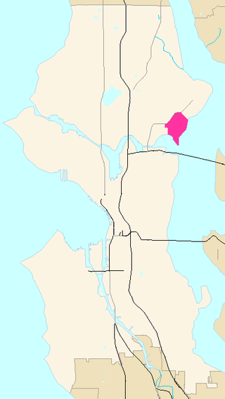
Hawthorne Hills is a residential neighborhood in Seattle, Washington. It is officially split between the neighborhoods of Bryant and Windermere, but is generally recognized as a distinct neighborhood. The northern boundary is Northeast 65th Street. The southern and eastern boundary is Sand Point Way. The western boundary is 40th Avenue Northeast. Hawthorne Hills is bounded on the north by View Ridge, on the east by Windermere, on the south by Laurelhurst, and on the west by Bryant. There is a sign for the neighborhood along Sand Point Way.
North Beach / Blue Ridge is a neighborhood in the city of Seattle, in the U.S. state of Washington.

Madison Valley is a neighborhood in Seattle located east of Capitol Hill; west of Washington Park; south of Montlake; and north of Madrona.

Squire Park is a neighborhood in the city of Seattle, in the U.S. state of Washington. According to the Squire Park Community Council, it is bounded on the south by S. Jackson Street, on the west by 12th Avenue and 12th Avenue S., on the north by E. Union Street, and on the east by 23rd Avenue and 23rd Avenue S., placing it within the Central District. Its main thoroughfares are E. Jefferson and Cherry Streets and E. Yesler Way and 14th Avenue. Swedish Medical Center's Cherry Hill campus is located here, Seattle University, a Jesuit University has part of its campus in Squire Park, as the Admissions, some dormitories and Athletics departments are east of 12th Avenue.

Olympic Hills is a neighborhood in the Lake City district of Seattle, Washington.
Pinehurst is a neighborhood in the Northgate area of Seattle, Washington, United States. It is bounded by NE 145th Street to the north, NE Northgate Way to the south, I-5 to the west, and Lake City Way to the east. These boundaries were determined by the Pinehurst Community Council. Pinehurst's northern boundary of NE 145th Street makes Pinehurst one of the northernmost neighborhoods in the city of Seattle.

The Ballard Avenue Historic District is a section of downtown Ballard in Seattle, Washington, that was listed on the National Register of Historic Places in 1976. The district consists of Ballard Avenue N.W. between N.W. Market Street and N.W. Dock Place, and is located near to and along Salmon Bay. After initial work by the Ballard Avenue Association and the city of Seattle's Urban Conservation Division, Seattle mayor Wes Uhlman signed the ordinances that led to the national recognition of the area. The neighborhood of Ballard is known for a large historic population and presence of immigrants from Sweden, and King Gustaf of Sweden read the proclamation inducting the district to the historical registry in 1976, and at the same time dedicated the new bell tower at Ballard's Marvin's Garden Park, which housed the original bell from Ballard's old city hall. The historic markers that can be seen on 26 of the buildings were created and erected by the Ballard Historical Society.

Marra Farm, a 4-acre (1.6 ha) plot of land in Marra-Desimone Park, South Park, Seattle, Washington is one of only two historic agricultural parcels inside Seattle city limits that retains an agricultural use today; the other is Picardo Farm.

Loyal Heights is a neighborhood in Seattle, Washington. It is considered part of greater Ballard.
