Related Research Articles

Taumatawhakatangihangakoauauotamateaturipukakapikimaungahoronukupokaiwhenuakitanatahu is a hill near Porangahau, south of Waipukurau in southern Hawke's Bay, New Zealand. The height of the hill is 305 metres (1,001 ft). The hill is notable primarily for its unusually long name, which is of Māori origin; it is often shortened to Taumata for brevity. It has gained a measure of fame as it is the longest place name found in any English-speaking country, and possibly the longest place name in the world, according to World Atlas. The name of the hill has also been listed in the Guinness World Records as the longest place name. Other versions of the name, including longer ones, are also sometimes used.

Codfish Island / Whenua Hou is a small island located to the west of Stewart Island / Rakiura in southern New Zealand. It reaches a height of 250 m (820 ft) close to the south coast. The island is home to Sirocco, an internationally famous kākāpō, a rare species of parrot.
Manaaki Whenua – Landcare Research is a New Zealand Crown Research Institute whose focus of research is the environment, biodiversity, and sustainability.

Te Ture Whenua Māori Act 1993 is a statute of the Parliament of New Zealand to "reform the laws relating to Māori land in accordance with the principles set out in the Preamble". These principles "reaffirm" the Treaty of Waitangi "relationship between the Māori people and the Crown" and "recognise that land is taonga tuku iho of special significance to Māori people". To that end, the principles "promote the retention of ... land in the hands of its owners, their whanau, and their hapu, and to protect wahi tapu". Further, they "facilitate the occupation, development, and utilisation of that land for the benefit of its owners, their whanau, and their hapu".
Toitū Te Whenua Land Information New Zealand (LINZ) is the public service department of New Zealand charged with geographical information and surveying functions as well as handling land titles, and managing Crown land and property. The minister responsible is the Minister for Land Information, and was formerly the Minister of Survey and Land Information. LINZ was established in 1996 following the restructure of the Department of Survey and Land Information (DOSLI), which was itself one of the successor organisations to the Department of Lands and Survey.
The New Zealand Geographic Board Ngā Pou Taunaha o Aotearoa (NZGB) was established by the New Zealand Geographic Board Act 1946, which has since been replaced by the New Zealand Geographic Board Act 2008. Although an independent institution, it is responsible to the Minister for Land Information.
The Māori Land Court is the specialist court of record in New Zealand that hears matters relating to Māori land.

Whirinaki Te Pua-a-Tāne Conservation Park is a publicly accessible conservation park in the North Island of New Zealand. The park is centered on the town of Minginui and part of the eastern boundary flanks Te Urewera. The Whirinaki Forest is one of the world's last prehistoric rainforests.

Steeple Rock/Te Aroaro-o-Kupe is a large rock off Seatoun at the west of the entrance to Wellington Harbour, rising 7 metres (23 ft) above sea level. The rock plays a role in warning ships off the coast. It is the location of a marine light and an unbeaconed trig station.
Rangikaiamokura Wirihana Hetet is a Maori master-carver of Ngāti Tuwharetoa and Ngāti Maniapoto descent.
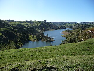
Lake Disappear is an intermittent volcanogenic lake situated in the North Island of New Zealand, just over 20 km from Raglan, 4 km beyond Bridal Veil waterfall. It has also been described as a solution lake. The south end can be seen from Kawhia Rd and, when the north end is full, it can be seen from the point which is at the end of Plateau Rd on the Pipiwharauroa Way. It is the largest known polje in the country, though another large one is in Paparoa National Park.
The judiciary of New Zealand is responsible for the system of courts that interprets and applies the laws of New Zealand. It has four primary functions: to provide a mechanism for dispute resolution; to deliver authoritative rulings on the meaning and application of legislation; to develop case law; and to uphold the rule of law, personal liberty and human rights. The judiciary is supported in its work by an executive department, the Ministry of Justice.

The cartography of New Zealand is the history of surveying and creation of maps of New Zealand. Surveying in New Zealand began with the arrival of Abel Tasman in the mid 17th century. Cartography and surveying have developed in incremental steps since that time till the integration of New Zealand into a global system based on GPS and the New Zealand Geodetic Datum 2000.
The Ngawapurua railway station on the Wairarapa Line was located in the Tararua District of the Manawatū-Whanganui region in New Zealand’s North Island.
Ruby Bay is a settlement in the Tasman District of New Zealand's upper South Island. It is located between Māpua and Tasman on Te Mamaku / Ruby Bay.
Date and time notation in New Zealand most commonly records the date using the day-month-year format, while the ISO 8601 format (2022-03-27) is increasingly used for all-numeric dates, such as date of birth. The time can be written using either the 12-hour clock or the 24-hour clock (10:33).
Te Poporo / Bulli Point is a point on Lake Taupō, in the central North Island of New Zealand. The point is a popular spot for rock jumping.

Puhi Kai Iti / Cook Landing National Historic Reserve is one of four national reserves in New Zealand. The reserve commemorates the arrival of both Māori and Pākehā in New Zealand. The Cook Monument, unveiled in 1906, was intended to mark the location where James Cook first landed on the islands in 1769 during his first voyage. The granite obelisk monument is now "barely within sight or scent of the sea", as the shoreline was altered by land reclamation as part of expansion at the port of nearby Gisborne. In 1966, the New Zealand Historic Places Trust successfully negotiated to have the area surrounding the monument and a strip of land to the sea set aside as a reserve.
References
- Lists of British, Australian and New Zealand Surveyors-General, Government Geologists... Retrieved 5 September 2016