Related Research Articles
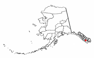
Naukati Bay is a census-designated place (CDP) in the Prince of Wales-Hyder Census Area of the Unorganized Borough of the U.S. state of Alaska. The population was 113 at the 2010 census, down from 135 in 2000.

NOAA Ship John N. Cobb was a National Oceanic and Atmospheric Administration research vessel in commission from 1970 to 2008. She was named for John Nathan Cobb and was the oldest commissioned ship in the NOAA fleet when she was decommissioned, having previously served in the United States Department of the Interior′s Fish and Wildlife Service from 1950 to 1956 and in the United States Fish and Wildlife Service′s Bureau of Commercial Fisheries from 1956 to 1970 as US FWS John N. Cobb.
Ilak Island is a small island in the eastern Delarof Islands, Aleutian Islands of Alaska.

USC&GS Thomas R. Gedney, originally USCS Thomas R. Gedney, was a survey ship in service in the United States Coast Survey from 1875 to 1878 and in the United States Coast and Geodetic Survey from 1878 to 1915.

Unalaska is a volcanic island in the Fox Islands group of the Aleutian Islands in the US state of Alaska located at 53°38′N167°00′W. The island has a land area of 1,051 square miles (2,720 km2). It measures 79.4 mi (127.8 km) long and 34.7 mi (55.8 km) wide. The city of Unalaska, Alaska, covers part of the island and all of neighboring Amaknak Island where the Port of Dutch Harbor is located. The population of the island excluding Amaknak as of the 2000 census was 1,759 residents.
Adugak Island (also spelled Adougakh, possibly from Aleut: Adudak; is a small island in the Fox Islands group in the Aleutian Islands of southwestern Alaska. It is about 1.2 miles long and is located 5.0 miles off the northwest coast of Umnak Island.
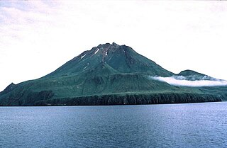
Uliaga Island is the northernmost member of the Islands of the Four Mountains group in the Aleutian Islands of southwestern Alaska. The island's name is probably derived from the Aleut place name ulaĝa, which is itself derived from ulaẍ - "bearberry." The triangular shaped island measures about 2.4 miles (3.9 km) across and consists of a single stratovolcano cone that reaches a height of 2,913 feet (888 m). The island has an area of 3.44 square miles (8.9 km2). No eruptions have been recorded in historical times, though it is thought to have been active at some time during the Holocene Epoch.

USC&GS Carlile P. Patterson was a survey ship of the United States Coast and Geodetic Survey in operation between 1883 and 1918. Subsequently, she had a brief period of naval service and fifteen seasons as a merchant vessel before she was wrecked on the Alaska coast in 1938.

USS Mobjack (AVP-27/AGP-7) was a motor torpedo boat tender in commission in the United States Navy from 1943 to 1946. She saw service in the Pacific theater during the latter portion of World War II.

USS Surveyor was an armed steamer that served in the United States Navy from 1917 to 1919. Prior to her U.S. Navy service, she operated as the survey ship USC&GS Surveyor for the United States Coast and Geodetic Survey in 1917, and she returned to that role after her U.S. Navy decommissioning, remaining in Coast and Geodetic Survey service until 1956.

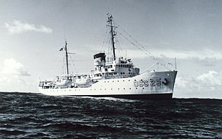
NOAA Ship Surveyor was an oceanographic survey ship in commission in the National Oceanic and Atmospheric Administration (NOAA) from 1970 until 1995. Prior to her NOAA career, she was in commission in the United States Coast and Geodetic Survey from 1960 to 1970 as USC&GS Surveyor. She was the second and last Coast and Geodetic Survey ship named Surveyor and has been the only NOAA ship thus far to bear the name.

USC&GS Yukon was a schooner that served as a survey ship in the United States Coast Survey from 1873 to 1878 and in its successor agency, the United States Coast and Geodetic Survey, from 1878 to 1894. She was the pioneering Coast Survey ship in many of the waters of the Territory of Alaska, including the Bering Sea and the western Aleutian Islands, and she also operated extensively in California and Washington. She later entered commercial service as Elwood and was wrecked in 1895.

The first USC&GS Discoverer was a survey ship that served in the United States Coast and Geodetic Survey from 1922 to 1941.

Cordova Bay is a bay in the Alexander Archipelago of southeast Alaska. It opens onto Dixon Entrance to the south, between Cape Muzon on Dall Island and Point Marsh. The name Puerto Cordova y Cordova was given by the Spanish explorer Lieutenant Don Jacinto Caamaño in 1792, in honor of Admiral Luis de Córdova y Córdova. The name was published by George Vancouver in 1798.
The second USC&GS Explorer was a survey ship that served in the United States Coast and Geodetic Survey from 1940 to 1968. She operated in the Pacific Ocean from 1940 to 1960, seeing service there during World War II, and in the Atlantic Ocean from 1960 to 1968.

Isanotski Strait is a strait connecting the northern Gulf of Alaska with the Bering Sea, in the U.S. state of Alaska. Isanax̂ is the Aleut name for present day Isanotski Strait, and means gap, hole, rent, or tear in the Aleut language which was rendered as Isanotski in transliterated Russian. The strait appears as Исанакъ in 1802 and Исаноцкый in 1844 on Russian maps.

Rear Admiral Harley Dean Nygren was an American military officer who served in the United States Coast and Geodetic Survey Corps, its successor, the Environmental Science Services Administration Corps, and the ESSA Corps's successor, the National Oceanic and Atmospheric Administration Commissioned Officer Corps. He served as the first Director of the NOAA Corps.

NOAAS George B. Kelez, previously NOAAS George B. Kelez, was an American research vessel in commission in the National Oceanic and Atmospheric Administration (NOAA) fleet from 1972 to 1980. Prior to her NOAA career, she operated under the United States Fish and Wildlife Service′s Bureau of Commercial Fisheries from 1962 to 1970 as US FWS George B. Kelez and the National Marine Fisheries Service from 1970 to 1972 as NOAAS George B. Kelez.

MV Brown Bear was an American research vessel in commission in the fleet of the United States Department of Agriculture′s Bureau of Biological Survey and Alaska Game Commission from 1934 to 1940 and in the fleet of the United States Department of the Interior′s Fish and Wildlife Service from 1940 to 1942 and from 1946 to 1951, under the control of the University of Washington from 1952 to 1965, and in commission in the fleet of the United States Fish and Wildlife Service from 1965 to 1970 and of the National Oceanic and Atmospheric Administration′s National Marine Fisheries Service (NMFS) from 1970 to 1972.
Bendel Island is an island located in the Aleutians East Borough, Gulf of Alaska, Southwest of mainland Alaska, United States. The island is part of an island group named the Shumagin Islands, which consist of 20 islands, and lies between the islands of Big Koniuji and Nagai.
References
- Ocean Grafix NOAA Nautical Chart: Alaska #16514
- Placesnames.com Surveyor Bay
- Eachtown.com Surveyor Bay, Alaska
- NOAA History, A Science Odyssey: Tools of the Trade: Ships: Coast and Geodetic Survey Ships: Surveyor
Coordinates: 53°15′41″N167°34′02″W / 53.26139°N 167.56722°W
| | This article about a location in the Aleutians West Census Area, Alaska is a stub. You can help Wikipedia by expanding it. |