Suldal is a municipality in the northeast corner of Rogaland county, Norway. It is located in the traditional district of Ryfylke. Since 1965, the administrative centre of Suldal is the village of Sand i Ryfylke. Other villages in Suldal include Hålandsosen, Jelsa, Marvik, Nesflaten, and Suldalsosen.

Aksdal is the administrative centre of Tysvær municipality, Norway. The village is located on the northern shore of the large lake Aksdalsvatnet, at the junction of the European route E134 and European route E39 highways. The village of Førre lies about 3 kilometres (1.9 mi) to the west of Aksdal and the village of Grinde lies about 1.5 kilometres (0.93 mi) to the east. Aksdal Church is located in Aksdal.
Nedstrand is a village in Tysvær municipality in Rogaland county, Norway. The village is located on the southeastern coast of the Nedstrand peninsula, at the confluence of the Nedstrandsfjorden and Vindafjorden. The village of Hindaråvåg lies just west of Nedstrand, and Nedstrand Church is located there. The 0.32-square-kilometre (79-acre) village of Nedstrand has a population (2014) of 240, giving the village a population density of 750 inhabitants per square kilometre (1,900/sq mi).
Eike is a village in Karmøy municipality in Rogaland county, Norway. The village is located along the western shore of the Førresfjorden, just southeast of the town of Haugesund. The village of Eike, lies just south of the border with the neighboring municipality of Tysvær. Eike is considered part of the larger urban area of Førre, which is centered over the border in Tysvær. The village of Norheim lies about 4 kilometres (2.5 mi) to the west and the village of Vormedal lies about 6 kilometres (3.7 mi) to the southwest.

Aksdalsvatnet is a lake in the municipality of Tysvær in Rogaland county, Norway. The 3.46-square-kilometre (1.34 sq mi) lake lies southeast of the village of Førre and south of the village of Aksdal. The European route E134 highway runs along the northern shore of the lake and the European route E39 highway runs along the eastern shore of the lake.
Stakkastadvatnet is a lake on the border of Rogaland and Hordaland counties in Norway. The 2.92-square-kilometre (1.13 sq mi) lake mostly lies in Rogaland along the municipal borders of Haugesund and Tysvær. A very small portion of the northern part of the lake crosses over into the municipality of Sveio in Hordaland county. The lake lies about 6 kilometres (3.7 mi) northeast of the town of Haugesund. The lake has a small dam on the northwestern edge of the lake. The natural outlet of the lake flows through the dam and into the nearby lake Vigdarvatnet, located to the north.
Hervik is a village in Tysvær municipality in Rogaland county, Norway. The village is located on the western shore of the Herviksfjorden, about 6 kilometres (3.7 mi) east of the village of Tysværvåg and about 8 kilometres (5.0 mi) northeast of the Kårstø industrial site. The village is known for production of fruit syrup, juice, and jam. Products are sold by mail order, at 7-Eleven and in delicatessens nationwide in Norway.
Grinde is a village in Tysvær municipality in Rogaland county, Norway. The village is located at the western end of the Grindafjorden, a couple of kilometers east of the villages of Aksdal and Førre. Grinde lies along the European route E39-European route E134 highway.
Yrke or Yrkje is a village in Tysvær municipality in Rogaland county, Norway. The village is located at the western end of the Yrkefjorden, a branch off of the main Vindafjorden. The village lies on a small isthmus between the Yrkefjorden and the Skjoldafjorden, along the County Road 515, the only road over the isthmus connecting the peninsula to the mainland. The village of Skjoldastraumen lies about 5 kilometres (3.1 mi) to the northwest and the villages of Hindaråvåg and Nedstrand lie about 20 kilometres (12 mi) to the southeast.
Nedstrand is a former municipality in Rogaland county, Norway. The 119-square-kilometre (46 sq mi) municipality was located along the Nedstrandfjorden, an inner branch off the main Boknafjorden. The municipality encompassed the majority of the Nedstrand peninsula. Originally it also included the Sjernarøyane islands and the western part of the island of Ombo in the fjord to the south. The administrative centre of the municipality was the village of Nedstrand. Nedstrand Church is located in Hindaråvåg, a small village just west of Nedstrand village. Today, the area is part of the large municipality of Tysvær.
Hindaråvåg or Hinderåvåg is a village in Tysvær municipality in Rogaland county, Norway. The village is located along the Nedstrandsfjorden, on the southern coast of Tysvær. The village of Nedstrand lies about 3 kilometres (1.9 mi) east of Hindaråvåg. The village is the site of Nedstrand Church. The Tveit Upper Secondary School is also located here. This is the only agriculture school in Rogaland county.

Førre or Førresfjorden is a village in Tysvær municipality in Rogaland county, Norway. The village is located at the northern end of the Førresfjorden. A portion of the urban area of this village extends over the municipal border into neighboring Karmøy municipality. The 3.6-square-kilometre (890-acre) village has a population (2014) of 5,362 which gives the village a population density of 1,489 inhabitants per square kilometre (3,860/sq mi).
Skjoldastraumen is a village in Tysvær municipality in Rogaland county, Norway. The village is located along the Skjoldafjorden, about 10 kilometres (6.2 mi) east of the village of Grinde and about 5 kilometres (3.1 mi) northwest of the village of Yrke. The village lies on one of the narrowest parts of the fjord, where there is a set of locks on the fjord to raise and lower boats. The village is the site of the Skjoldastraumen Church.
Tysvær or Tysværvåg is a village in Tysvær municipality in Rogaland county, Norway. The village is located at the end of the small Tysværvågen bay, about 2 kilometres (1.2 mi) off of the European route E39 highway. The nearby village of Susort lies about 8 kilometres (5.0 mi) south of the village of Tysvær, the municipal centre of Aksdal lies about 12 kilometres (7.5 mi) to the north, and the village of Hervik lies about 7 kilometres (4.3 mi) to the east. Tysvær Church is located in the village, serving the southwest portion of the municipality.
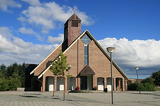
Aksdal Church is a parish church in Tysvær municipality in Rogaland county, Norway. It is located in the village of Aksdal. The church is part of the Førresfjorden parish in the Haugaland deanery in the Diocese of Stavanger. The red, brick church was built in 1995 using plans drawn by the architect Stein Jarle Helgeland. The church cost about 21.3 million kr to build and it seats about 450 people.

Tysvær Church is a parish church in Tysvær municipality in Rogaland county, Norway. It is located in the village of Tysværvåg. The church is part of the Tysvær parish in the Haugaland deanery in the Diocese of Stavanger. The white, wooden church was built in 1852 using plans by the architect Hans Linstow. The church seats about 450 people.

Ognøya or Ogn is an island in Bokn municipality in Rogaland county, Norway. The 5.5-square-kilometre (2.1 sq mi) island lies between the mainland and the islands of Austre Bokn and Vestre Bokn. The islands are connected by a series of bridges as part of the European route E39 highway. The industrial area of Kårstø lies just north of Ognøya on the mainland.