Suvo Rudište

Last updated
Suvo Rudište
Pan Pancicev vrh.jpg
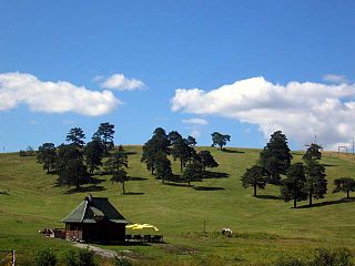
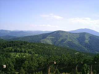
Pančić's Peak (left) and Suvo Rudište Peak (right), highest peaks on Kopaonik.
Highest point
Elevation 1,976 m (6,483 ft)
Coordinates 43°16′18″N20°49′04″E / 43.2715803°N 20.8178176°E / 43.2715803; 20.8178176 Coordinates: 43°16′18″N20°49′04″E / 43.2715803°N 20.8178176°E / 43.2715803; 20.8178176
Geography
Relief map of Serbia.png
Red triangle with thick white border.svg
Suvo Rudište
Location in Serbia
Location Serbia
Parent range Kopaonik

Suvo Rudište (Serbian Cyrillic : Суво Рудиште) is the name of a mountain plateau and its peak at 1976 m, belonging to the Kopaonik mountain (and Kopaonik mountain range) in Serbia.

The Serbian Cyrillic alphabet is an adaptation of the Cyrillic script for the Serbian language, developed in 1818 by Serbian linguist Vuk Karadžić. It is one of the two alphabets used to write standard modern Serbian, Bosnian and Montenegrin, the other being Latin.

Plateau An area of a highland, usually of relatively flat terrain

In geology and physical geography, a plateau, also called a high plain or a tableland, is an area of a highland, usually consisting of relatively flat terrain, that is raised significantly above the surrounding area, often with one or more sides with steep slopes. Plateaus can be formed by a number of processes, including upwelling of volcanic magma, extrusion of lava, and erosion by water and glaciers. Plateaus are classified according to their surrounding environment as intermontane, piedmont, or continental.

Kopaonik

Kopaonik is a mountain located in Serbia. It is the largest mountain range in Serbia. The highest point is the Pančić's Peak with 2,017 m (6,617 ft). The central part of the Kopaonik plateau was declared a national park in 1981 which today covers an area of 121.06 km2 (46.74 sq mi).

Contents

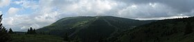
The locale of Suvo Rudište (a tourist settlement), in Kopaonik, is a center of the Kopaonik National Park. The area is a natural reservation, covering 50,63 hectares, located on the northeastern slopes of the Suvo Rudište Peak, on part of the slopes stretching from Pančić's Peak towards the source prong of Brzećka reka including the locale of Krčmar voda.

Kopaonik (Raška) Village in Raška District, Serbia

Kopaonik is a village in the municipality of Raška, Serbia. According to the 2002 census, the village has a population of 18 people.

Pančićs Peak mountain in Serbia

Pančić's Peak is the highest point in the Kopaonik mountain range, which straddles southern Serbia and northern Kosovo. The peak is 2,017 m high, located in the Brus municipality in Serbia. The Serbia–Kosovo demarcation line lies some 50 m south of the summit. Pančić's Peak is part of the Suvo Rudište mountainous plateau and natural zone of the Kopaonik National Park. The Kopaonik tourist center operates cable cars to Pančić's Peak and Suvo Rudište Peak.

The area was studied by botanist Josif Pančić (1814–1888).

Josif Pančić botanist

Josif Pančić was a Serbian botanist, doctor, a lecturer at the Great School in Belgrade and the first president of the Serbian Royal Academy. He extensively documented the flora of Serbia, and is credited with having classified many species of plants which were unknown to the botanical community at that time. Pančić is credited for discovering the Serbian Spruce. He is regarded as the father of Serbian botany.

It was a site of operations in World War II. [1]

Hotels in the Kopaonik tourist centre, view from the slopes of Suvo Rudiste. Hoteli na Kopaoniku.jpg
Hotels in the Kopaonik tourist centre, view from the slopes of Suvo Rudište.

Related Research Articles

Geography of Serbia

Serbia is a sovereign state situated at the crossroads of Central and Southeast Europe, covering the far southern edges of the Pannonian Plain (Vojvodina) and the central Balkans. It shares borders with Bosnia-Herzegovina, Bulgaria, Croatia, Hungary, North Macedonia, Montenegro, Romania and Albania through the disputed territory of Kosovo. It is landlocked, although access to the Adriatic Sea is available through Montenegro, and the Danube River provides shipping access to inland Europe and the Black Sea.

Tara (mountain) Mountain in western Serbia

Tara is a mountain located in western Serbia. It is part of Dinaric Alps and stands at 1,000 to 1,590 m above sea level. The mountain's slopes are clad in dense forests with numerous high-altitude clearings and meadows, steep cliffs, deep ravines carved by the nearby Drina River and many karst, or limestone caves. The mountain is a popular tourist centre. Tara's national park encompasses a large part of the mountain. The highest peak is Zborište, at 1,544 m (5,066 ft).

Zlatibor mountain region situated in the western part of Serbia

Zlatibor is a mountainous region situated in the western part of Serbia.

Jevremovac Urban neighbourhood in Stari Grad, Belgrade, Serbia

Jevremovac Botanical Garden is the botanical garden of the University of Belgrade and also a surrounding urban neighborhood of Belgrade, the capital of Serbia. The garden is located in Belgrade's municipality of Stari Grad and is an administered by the University of Belgrade's Biology School.

Suva Planina mountain in Serbia

Suva Planina is a mountain in southeastern Serbia. It lies between towns of Niška Banja on the northwest and Babušnica on the southeast, with a ridge branching towards Bela Palanka on north. Its earlier name was Kunovica.

Radan (mountain) mountain in Serbia

Radan is a mountain in southern Serbia, near the town of Kuršumlija. Its highest peak, Šopot, has an elevation of 1,408 meters above sea level.

Golija mountain in Serbia

Golija (Srbija) is a mountain in southwestern Serbia, between towns of Ivanjica and Novi Pazar. It is part of the Dinaric mountain range. The mountain is heavily forested with significant biodiversity. It contains the Golija-Studenica Biosphere Reserve, the first UNESCO-MAB registered biosphere reserve in Serbia. It is also a small ski resort, with several historical monuments and monasteries. The highest peak is Jankov kamen at 1,833 m.

Maljen mountain in Serbia

Maljen is a mountain in western Serbia, just south of the city of Valjevo. It is well known as a summer and winter resort. The highest peak is Kraljev Sto, at 1,104 m (3,622 ft) above sea level, followed by Crni Vrh at 1,096 m (3,596 ft). On Maljen is situated resort Divčibare with 3 hotels, 24 holiday camps, two mountain lodges and two ski trails. During summer the slopes of the mountain are covered with flower meadows with white daffodils.

Pilj Waterfall waterfall

Pilj Waterfall or simply Pilj, is the third highest waterfall in Serbia, being discovered by geologists and alpinists only in 2002.

Povlen mountain in Serbia

Povlen is a mountain in western Serbia, located thirty kilometers west of Valjevo. It has several peaks, the three most important being Small Povlen, Middle Povlen and Big Povlen, which is, ironically, the lowest.

Gradac Monastery

Gradac Monastery an endowment of queen Helen was built from 1277 to 1282 during the reign of her son king Stefan Dragutin. It lies on the elevated plateau above the river Gradačka, at the edge of the forested slopes Golija. Gradac Monastery was declared Monument of Culture of Exceptional Importance in 1979, and it is protected by Serbia.

Kučaj mountain in Serbia

Kučaj is a mountain range in eastern Serbia. Its highest peak, Velika Tresta has an elevation of 1,284 meters above sea level. They belong to the Serbian extension of Carpathians, which separate the valleys of Great Morava and Timok.

Geology of Serbia

The regional geology of Serbia describes the geologic structure and history inside the borders of Serbia.

Goč mountain in Serbia

Goč is a mountainous area in central Serbia, about 15 km south of the spa town of Vrnjačka Banja. Its highest peak Ljukten has an elevation of 1,216 m (3,990 ft) above sea level.

Kopaonik ski resort Ski resort near Brus, Serbia

Kopaonik ski resort or Kopaonik ski center, is the largest center of winter tourism in Serbia, operated by public company "Skijališta Srbije". Located on the slopes of Kopaonik Mountain, it is mainly a destination for skiing and snowboarding, but also offers various other activities like tennis. In the area, there are several hotels and hostels, cafes, bars and night clubs.

References

  1. Petar M. Višnjić (1984). Bitka za Srbiju. Beogradska knjiga. pp. 88–90.

Further reading