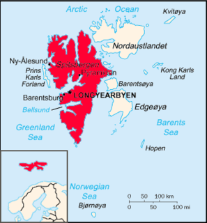
Oscar II Land is the land area between Isfjorden and Kongsfjorden on Spitsbergen, Svalbard. The 30 km (19 mi) long glacier Sveabreen divides Oscar II Land from James I Land.

James I Land is a land area on the northwestern part of Spitsbergen, Svalbard. It is named after King James I of England and Scotland. The 30 kilometer long glacier Sveabreen divides James I Land from Oscar II Land.
St. Jonsfjorden is a fjord in Oscar II Land at Spitsbergen, Svalbard. It has a length of 21 kilometer, and opens westwards into the strait of Forlandsundet. Several glaciers debouche into the fjord, including Gaffelbreen and Konowbreen from the north, a merge of Osbornebreen, Devikbreen, Vintervegen, Paulbreen and Bukkebreen at the bottom, and Vegardbreen, Charlesbreen and Bullbreen from the south.
Nordfjorden is a northern branch of the fjord Isfjorden at Spitsbergen, Svalbard. It is located between Bohemanneset and Kapp Thordsen, and branches further into the fjords Ekmanfjorden and Dicksonfjorden. The 30 kilometer long glacier Sveabreen debouches into the fjord.
Kapp Hammerfest is a headland on Svenskøya in Kong Karls Land, Svalbard. It is the most southern point of Svenskøya, and the headland has a length of about 1.5 kilometers. The headland is named after the Norwegian city of Hammerfest. North of the headland, at the western side of the Svenskøya, is Kyrkjevika with Antarcticøya and other smaller islands.

Petuniabukta is a bay in Dickson Land at Spitsbergen, Svalbard. It constitutes the northern branch of Billefjorden. The bay is named after the Scottish vessel SS Petunia. Northwest of the bay is the valley of Hørbyedalen and the glacier of Hørbyebreen.
Eidembukta is a bay in Oscar II Land at Spitsbergen, Svalbard. It has a width of about 4.5 kilometers, and is located at the southeastern side of Forlandsundet. The glacier of Eidembreen debouches into the bay. The bay is named after Norwegian politician and naval officer Ole Thorenius Eidem.
Trollheimen is a mountainous area in Oscar II Land at Spitsbergen, Svalbard, around the glacier of Eidembreen. Among the mountains of Trollheimen are Tussekallen, Runebomma, Heksefjellet, Huldrefjellet, Huldrehatten, Tomtegubben, and parts of Gunnar Knudsenfjella. North of Eidembreen is the glacier of Huldrebreen, and to the south are Heksebreen and Stallobreen.
Holmesletfjella is a mountain range in Oscar II Land at Spitsbergen, Svalbard. The range extends about seven kilometers, and comprises several peaks and the four kilometer long ridge of Skipperryggen. Holmesletfjella are located south of St. Jonsfjorden, between Løvliebreen and Bullbreen. They are named after captain and ship owner Hans Holmeslet.
Gunnar Knudsenfjella is a mountain group in Oscar II Land at Spitsbergen, Svalbard. The mountains are located south of St. Jonsfjorden, and are surrounded by the glaciers of Charlesbreen, Løvliebreen and Eidembreen.
Løvliebreen is a glacier in Oscar II Land at Spitsbergen, Svalbard. It has a length of about five kilometers, and is located between the mountain ranges of Gunnar Knudsenfjella and Holmesletfjella. The glacier debouches northwards towards St. Jonsfjorden. It is named after Norwegian businessperson Andreas Løvlie.
Skipperryggen is a mountain ridge in Oscar II Land at Spitsbergen, Svalbard. The ridge has a length about four kilometers, and is part of the mountain range of Holmesletfjella. Skipperryggen is located south of St. Jonsfjorden, between the glaciers of Vestgötabreen and Hydrografbreen. The ridge is named after captain and ship owner Hans Holmeslet.
Hydrografbreen is a glacier in Oscar II Land at Spitsbergen, Svalbard. The glacier has a length about eight kilometers, and extends from the mountain range of Holmesletfjella to Jørgenfjellet.
Vestgötabreen is a glacier in Oscar II Land at Spitsbergen, Svalbard. It has a length of about seven kilometers, and is located between Løvliefjellet and the mountain ranges of Holmesletfjella and Motalafjella. The glacier is named from the Swedish province of Västergötland.
Jørgenfjellet is a mountain in Oscar II Land at Spitsbergen, Svalbard. It reaches a height of 681 m.a.s.l. and is located at the southern side of the mountain area of Svartfjella. The mountain is named after Norwegian naval officer and hydrographic surveyor Jørgen Petersen-Hansen. It was ascended during an expedition in 1909, for geographical surveying. Between Jørgenfjellet and Holmesletfjella is the glacier of Hydrografbreen.
Svartfjella is a mountain area in Oscar II Land at Spitsbergen, Svalbard. It is located between the glacier of Bullbreen and the lowland of Svartfjellstranda, at the eastern side of Forlandsundet. The highest peak is 674 m.a.s.l., and the area extends over a length of about 4.5 kilometers.
Griegfjellet is a mountain in Nordenskiöld Land at Spitsbergen, Svalbard. It has a length of about 4.5 kilometers and contains several peaks, of which the highest is 781 m.a.s.l.. The mountain is part of Linnéfjella. It is named after Norwegian ship broker and politician Joachim Grieg.
Mathiesenfjella is a mountain group in Oscar II Land at Spitsbergen, Svalbard. The group is named after Norwegian businessman Haaken L. Mathiesen.
Kapp Bessels is a headland at Barentsøya, Svalbard. It is located at the northeastern coast of the island, and east of the glacier of Besselsbreen. The headland is named after German Arctic explorer Emil Bessels.

Krefftberget is a mountain group at Barentsøya, Svalbard. It is named after Australian zoologist Gerard Krefft, and is situated at the southern part of the island.


