
Carey Street is a road in the Holborn area of Central London. Located close to Lincoln's Inn Fields and the Royal Courts of Justice, it runs from Portugal Street to Chancery Lane parallel to the Strand to the south. New Square is a little to the north, connected by an arched gateway dating back to the 1697. While the western end of Carey Street is in the City of Westminster the eastern end beyond the junction with Serle Street is in the London Borough of Camden. It takes its name from Nicholas Carey who owned a house in the street in the seventeenth century.

Belsize Park Gardens is a street in the Belsize Park area of Hampstead in London. Located in the London Borough of Camden, it is residential street featuring white stucco Victorian era buildings. It runs roughly southeastwards from Belsize Avenue in Belsize Village before terminating at a junction with Eton Avenue, England's Lane and Primrose Hill Road. The Grade II listed pub The Washington, dating from around 1865, is located at its eastern end.

Carlton Vale is a street that runs through Kilburn and Maida Vale in London. Some of its route forms the boundary between the City of Westminster to the south and the London Borough of Brent to the north. To the west the street continues as Kilburn Lane through Queen's Park, while to the east it becomes Carlton Hill running into St. John's Wood. Carlton Vale crosses or meets several roads including Kilburn Park Road, Cambridge Road and Randolph Avenue.

Gloucester Avenue is a street in the Primrose Hill area of London, England. Located in the London Borough of Camden, it is a residential road featuring many nineteenth century properties including several pubs as well as the neo-Georgian Cecil Sharp House. For much of its route it runs adjacent to the West Coast Main Line out of Euston Station.

Eton Avenue is a street in the Belsize Park area of Hampstead in North London. Located in the London Borough of Camden, it runs eastward from Swiss Cottage tube station to a junction with England's Lane, Primrose Hill Road and Belsize Park Gardens by The Washington pub. Fellows Road and Adelaide Road run parallel to the south of Eton Avenue.

New End Square is a square in Hampstead, in the London Borough of Camden. It dates back to the early eighteenth century when it was located close to the Hampstead Wells spa on the adjacent Well Walk. Despite its name it is not rectangular. At its northern end is the Old White Bear pub dating back to 1704, on the corner with Well Road. Its southern end is at the junction between Flask Walk and Well Walk. New End street curls off from one corner of the square, eventually heading west to Heath Street.

Pond Street is located in Hampstead in the London Borough of Camden. It runs eastwards from Rosslyn Hill to South End Green, located in the old "South End" of the settlement. The street takes its name from an ancient pond at South End Green, a source of the River Fleet, and has been known by this name since at least 1678. The pond survived into the Victorian era.

South End Road is located in Hampstead in the London Borough of Camden. It takes its name from the old "South End" of Hampstead. It runs southwards from the junction with East Heath Road and Downshire Hill alongside the southern edge of Hampstead Heath until reaching South End Green where it meets Pond Street and two roads running off east towards Gospel Oak. South Hill Park street runs north towards Hampstead Ponds. Keats Grove runs off the road and forms a triangle with Downshire Hill noted for its surviving Regency architecture.

Hampstead Grove is a street in Hampstead in the London Borough of Camden. It heads northwards from Holly Hill running towards Hampstead Heath, but curving back towards Lower Terrace which connects it to the Heath. It runs roughly parallel to Heath Street to its east. It takes its name from the groves of trees that marked the landscape.
Holly Hill is a street in Hampstead in the London Borough of Camden. It runs northwards from a junction with Hampstead High Street and Heath Street, Hampstead heading uphill to a grassy triangle named Holly Bush Hill where it meets Windmill Hill and Hampstead Grove by the entrance to Fenton House. It takes its name from a grove of holly bushes which stood on the hill until the 1940s. In the eighteenth century it was known as Cloth Hill, likely because local laundresses using Hampstead Wells hung their clothes out on the Holly Bushes to dry. Holly Mount turns eastwards off the street and forms a cul-de-sac, although there are steps linking it to Heath Street below. Holly Mount contains The Holly Bush pub, which was once linked to the nearby assembly rooms. Notable residents of Holly Hill have included the artists George Romney and Derek Hill, both commemorated with blue plaques. A number of properties are now Grade II listed. Romney's House at 5 Holly Bush Hill is Grade I listed. Running uphill to the west is Mount Vernon which also features notable historic properties and Holly Walk.

Loudoun Road is a street in the St John's Wood area of London. Most of its route is in the City of Westminster, but it crosses into the London Borough of Camden at its northern end in South Hampstead. It runs roughly parallel to Finchley Road to its east while Abbey Road, London is to the west. It runs north from Grove End Road, not far from St John's Wood tube station, and crosses or is joined by a number of streets including Marlborough Place, Carlton Hill and Boundary Road. It finishes at a roundabout junction with several streets including Belsize Road and Fairhazel Gardens. South Hampstead railway station is at the northern end of the street.

Adelaide Road is a street in London running east to west between Chalk Farm and Swiss Cottage. Located in the London Borough of Camden it is part of the longer B509 route which continues as Belsize Road through South Hampstead. The Belsize Park area of Hampstead is to its north while Primrose Hill is to the south. It runs parallel to Fellows Road and Eton Avenue. Along its route it meets or is crossed by several streets including Primrose Hill Road and Avenue Road. At its eastern end is Chalk Farm tube station at the junction with Haverstock Hill, which opened in 1907. It takes its name from Queen Adelaide, wife of William IV.

Broadhurst Gardens is a street in the London Borough of Camden running eastwards from West End Lane in West Hampstead and ending near to the Finchley Road. It forms the northern border of South Hampstead, and runs parallel to the Midland Main Line. It meets or is crossed by Priory Road, Fairhazel Gardens and Canfield Gardens.

Fitzjohns Avenue is a street in Hampstead, England. Located in the London Borough of Camden it runs northwards from College Crescent to join and become Heath Street in Hampstead Village. Running steeply uphill for much of its route Fitzjohns Avenue is joined or crossed by various other streets including Belsize Park, Belsize Lane, Maresfield Gardens, Netherhall Gardens, Akenfield Road and Lyndhurst Road. It is classified as part of the B511 road. It is also sometimes written as Fitzjohn's Avenue.

Oval Road is a street in the Camden Town area of London. It runs northwards from Gloucester Avenue near Parkway to the Regent's Canal, a little to the west of the centre of Camden Town. Close to its southern end is the junction with Delancey Street. It then heads northwards as Gloucester Crescent curves away and then rejoins the street while Regent's Park Terrace follows more closely beside Oval Road.

The Gatehouse is a public house in Highgate, London, located at a road junction where Highgate High Street, West Hill, North Hill and Hampstead Lane converge close to Pond Square. It stands on the site of the oldest recorded structure in Highgate Village. A toll road was constructed in the early fourteenth century and an arched gateway was constructed under which all passing had to pay. This gave its name to the area.
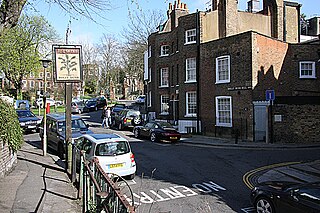
Pond Square is a garden square and village green in Highgate, London. Located close to Highgate High Street and The Gatehouse it is today in the London Borough of Camden. Swain's Lane runs off the square heading downhill past Highgate Cemetery.

Highgate West Hill is a street in Highgate, London. Located in the London Borough of Camden it runs north to south with Hampstead Heath off to its west and Highgate Cemetery away to the east. A number of streets run off the road including The Grove, Millfield Lane and Hillway. The route dates back to the medieval era.

Highgate High Street is located in Highgate in London. A high street, it provides the main shopping thoroughfare for the settlement at the top of Highgate Hill. It runs downhill from the western end and forms of the longer B519 that includes Highgate Hill towards Archway. At its western end is a crossroads by The Gatehouse pub where it meets Hampstead Lane, Highgate West Hill and North Road. Pond Square, the village green of Highgate, is located nearby. Other roads running off the High Street include Southwood Lane and South Grove. The High Street forms the border between the London Borough of Camden to the south and Haringey to the north, reflecting the historic parish boundaries between Hornsey and St Pancras.

Mansfield Road is a street in the Gospel Oak area of Hampstead. It runs east to west from a junction with Fleet Road and Southampton Road to Gospel Oak Station where it becomes Gordon House Road which runs on as far as the Highgate Road. Today it forms part of the B518 route.

