Uitenhage, officially renamed Kariega, is a South African town in the Eastern Cape Province. It is well known for the Volkswagen factory located there, which is the biggest car factory on the African continent. Along with the city of Port Elizabeth and the small town of Despatch, it forms the Nelson Mandela Metropolitan Municipality.
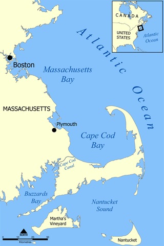
Cape Cod Bay is a large bay of the Atlantic Ocean adjacent to the U.S. state of Massachusetts. Measuring 604 square miles (1,560 km2) below a line drawn from Brant Rock in Marshfield to Race Point in Provincetown, Massachusetts, it is enclosed by Cape Cod to the south and east, and Plymouth County, Massachusetts, to the west. To the north of Cape Cod Bay lie Massachusetts Bay and the Atlantic Ocean. Cape Cod Bay is the southernmost extremity of the Gulf of Maine. Cape Cod Bay is one of the bays adjacent to Massachusetts that give it the name Bay State. The others are Narragansett Bay, Buzzards Bay, and Massachusetts Bay.
The following lists events that happened during 1875 in South Africa.
The M19 is a metropolitan route in the Nelson Mandela Bay Municipality in South Africa that connects Swartkops with Uitenhage via Despatch.

Gamtoos River or Gamptoos River is a river in the Eastern Cape Province, South Africa. It is formed by the confluence of the Kouga River and the Groot River and is approximately 645-kilometre (401 mi) long with a catchment area of 34,635 square kilometres (13,373 sq mi).

Gqeberha, previously named Port Elizabeth, and colloquially referred to as P.E., is a major seaport and the most populous city in the Eastern Cape province of South Africa. It is the seat of the Nelson Mandela Bay Metropolitan Municipality, South Africa's second-smallest metropolitan municipality by area. It is the sixth-most populous city in South Africa and is the cultural, economic and financial hub of the Eastern Cape.

The Gosthani rises in the Ananthagiri Hills of the Eastern Ghats and flows through the Borra Caves which lie near its source. It is the largest river flowing through Visakhapatnam city. It flows for 120 km before joining the Bay of Bengal through an estuary near Bheemunipatnam. The river basin drains the two coastal districts of Vizianagaram and Visakhapatnam. The basin exhibits a subdendritic and dendritic pattern of drainage. The Gosthani's is a minor river basin with a total drainage area of less than 2000 km2. Much of the basin is covered by khondalite group of gneissic rocks. About 3% of the total area of the Visakhapatnam district is under the Gosthani basin. The river is rainfed, receiving an average rainfall of 110 cm most of which comes from the south-west monsoon. There are several red sand hills near Bheemunipatnam, where the Gosthani joins the Bay of Bengal, which are reminiscent of the Chambal ravines. These are thought to have been formed six millennia ago due to shifts in the river's course following tectonic activity. The river joins the Bay of Bengal at Bhimli where it forms an estuary.
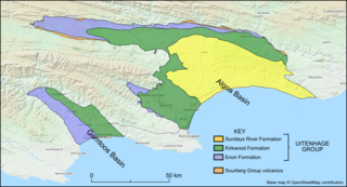
The Kirkwood Formation is a geological formation found in the Eastern and Western Cape provinces in South Africa. It is one of the four formations found within the Uitenhage Group of the Algoa Basin – its type locality – and in the neighbouring Gamtoos Basin. Outcrops of the Kirkwood are also found along the Worcester-Pletmos, Herbertsdale-Riversdale, Heidelberg-Mossel Bay, and Oudtshoorn-Gamtoos basin lines. At these basins the Kirkwood Formation underlies the Buffelskloof Formation and not the Sundays River Formation.
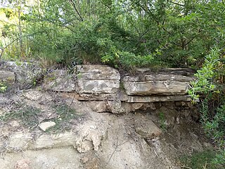
The Sundays River Formation is a geological formation found in the Eastern and Western Cape provinces in South Africa. It is the second youngest of the four formations found within the Uitenhage Group of the Algoa Basin, its type locality, and the only location where outcrops have been located. The Sundays River has been measured at a maximum thickness of 2,000 metres (6,600 ft).

The Albany thickets is an ecoregion of dense woodland in southern South Africa, which is concentrated around the Albany region of the Eastern Cape.
Metrorail Eastern Cape is the name given to the commuter rail services operated by Metrorail, a division of the Passenger Rail Agency of South Africa, in the Eastern Cape province of South Africa. There are two lines, one connecting Port Elizabeth, Despatch and Uitenhage, and the other connecting East London, Mdantsane and Berlin.
Despatch is a small town in the Eastern Cape Province of South Africa situated between Port Elizabeth and Uitenhage with an estimated population of 40 000. It forms part of the Nelson Mandela Bay Metropolitan Municipality which includes Port Elizabeth and Uitenhage, and has collectively a population of over 1.3 million.
iBhayi is a large township near Port Elizabeth, South Africa. It is the largest township in the Eastern Cape province and the ninth largest in South Africa after Mitchells Plain near Cape Town in the Western Cape.
Motherwell is a township in the Eastern Cape province of South Africa. It forms part of the Nelson Mandela Bay Metropolitan Municipality which is the metropolitan area comprising Port Elizabeth, Despatch, Uitenhage and other surrounding towns.
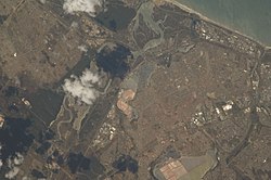
Swartkops is a village in Nelson Mandela Bay in the Eastern Cape province of South Africa.

The Cape Government Railways 0-4-0ST 1881 Coffee Pot was a South African steam locomotive from the pre-Union era in the Cape of Good Hope.
In South Africa, as elsewhere in the world, the railways played a huge part in development and growth on nearly all terrains in the country. Conversely, events in South Africa and its neighbours over the years had a huge influence on the development of railways.
The Uitenhage Group is one of three geological groups, which comprise the onshore and offshore post-Karoo middle to lower Upper Mesozoic geological rock units in South Africa. Stratigraphically, the Uitenhage Group overlies the Suurberg Group and is overlain by the Algoa Group. It contains four formations that range in age from late Early Jurassic and late Early Cretaceous in age.

The Buffelskloof Formation is a geological formation found in the Western Cape province in South Africa. It is the uppermost of the four formations found within the Uitenhage Group of the Algoa Basin. It is considered an informal formation by some of the literature as it is very thin and only outcrops as isolated horizons in the Oudshoorn-Gamtoos, Herbertsdale-Mossel Bay, and Heidelberg-Riversdale Basins. Along the Worcester-Pletmos Basin, it occurs in patches along the southern flanks of the Langeberg mountain range - from Worcester in the west and as far as Mossel Bay in the east. From Mossel Bay this formation is inter fingered by the informal Hartenbos Formation. The Buffelskloof and Hartenbos Formations only occur in the Oudshoorn-Gamtoos and Herbertsdale-Mossel Bay basins and seem to correlate to the Sundays River Formation in age.
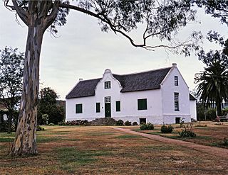
Cuyler Manor, or Cuyler House, is a historic house museum in the Western Region of the Eastern Cape province of South Africa. Cuyler Manor was designated as a Provincial Heritage Site on March 14, 1980. In addition to the farm house, the visitor house, coach house, wagon house, and mill house are protected historic sites, all located between the Swartkops River and a South African Railways facility.