
Bonita is a census-designated place (CDP) in southern San Diego County, California, nestled between the cities of Chula Vista, National City, and San Diego. The population was 12,538 at the 2010 census.
Sweetwater River may refer to:
Sweetwater or Sweet Water may refer to:
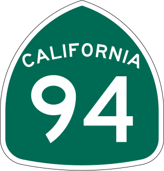
State Route 94 (SR 94) is a state highway in the U.S. state of California that is 63.324 miles (101.910 km) long. The western portion, known as the Martin Luther King Jr. Freeway, begins at Interstate 5 (I-5) in Downtown San Diego and continues to the end of the freeway portion past SR 125 in Spring Valley. The non-freeway segment of SR 94 that continues east through the mountains to I-8 near Boulevard is known as Campo Road.

The Sweetwater Union High School District is a school district headquartered in Chula Vista, California. As of 2011, the school district is the largest secondary school district in California.

State Route 54 (SR 54) is a state highway in the U.S. state of California that consists of two segments in San Diego County. The westernmost part of the highway is known as the South Bay Freeway, beginning at Interstate 5 (I-5) in National City and running along the Sweetwater River before ending at the intersection with SR 125 and Jamacha Boulevard near Spring Valley. SR 54 then resumes at SR 94 in Rancho San Diego as an undivided highway that leads to the city limits of El Cajon. County Route S17 (CR S17) connects the two portions of the highway; the center portion of SR 54 was never constructed.

The South Bay, also known as South County, is a region in southwestern San Diego County, California consisting of the cities and unincorporated communities of Bonita, Chula Vista, East Otay Mesa, Imperial Beach, Lincoln Acres, National City, and South San Diego.
Otay Mesa is a community in the southern exclave of the city of San Diego, just north of the U.S.–Mexico border.

The Sweetwater River is a 55-mile (89 km) long stream in San Diego County, California.
Dehesa is a populated place in San Diego County, California. Dehesa is located along the Sweetwater River and Dehesa Valley between Harbison Canyon, Crest, Alpine, and Granite Hills.

The Cuyamaca Mountains, locally the Cuyamacas, are a mountain range of the Peninsular Ranges System, in San Diego County, southern California. The mountain range runs roughly northwest to southeast. The Laguna Mountains are directly adjacent to the east, with Palomar Mountain and Hot Springs Mountain more distant to the north.
The San Diego Aqueduct, or San Diego Project, is a system of four aqueducts in the U.S. state of California, supplying about 70 percent of the water supply for the city of San Diego. The system comprises the First and Second San Diego Aqueducts, carrying water from the Colorado River west to reservoirs on the outskirts of San Diego. The 70-mile (110 km) First Aqueduct consists of the pipelines 1 and 2, which run from the Colorado River Aqueduct near San Jacinto, California, to the San Vicente Reservoir, approximately 15 miles (24 km) northeast of the city. Pipelines 3 and 4 make up the 94-mile (151 km) Second Aqueduct. Together, these four pipelines have a capacity of 826 cubic feet per second (23.4 m3/s). The smaller, 12.5-mile (20.1 km) Fallbrook-Ocean Branch branches from the First Aqueduct into Murray Reservoir. The La Mesa-Sweetwater Branch originates from the First Aqueduct, flowing into the Sweetwater Reservoir.
Nestor is a residential neighborhood in the southern section of San Diego, California, part of the Otay Mesa-Nestor community planning area. It neighbors Palm City and Otay Mesa West to the east, Egger Highlands to the north, San Ysidro to the southeast and the Tijuana River Valley to the south. Major thoroughfares include Coronado Avenue, Saturn Boulevard, Hollister Street, and Tocayo Avenue.

The Sweetwater Dam is a dam across the Sweetwater River in San Diego County, California. It is located approximately 12 miles (19 km) east of San Diego, 9 miles (14 km) and borders Bonita to the southwest and La Presa to the northeast. The 108-foot (33 m)-high masonry arch dam impounds 960-acre (390 ha) Sweetwater Reservoir.

Sweetwater Reservoir is a 960-acre (390 ha) artificial lake in San Diego County, California, formed by the Sweetwater Dam on the Sweetwater River. Construction of the dam was completed in 1888.

Loveland Dam is a dam across the Sweetwater River in San Diego County, California. The dam forms long, narrow Loveland Reservoir which stores 25,387 acre-feet (31,314,000 m3) of water. It is operated primarily for flood control and municipal water storage in conjunction with downstream Sweetwater Dam but the reservoir is also open to the public for fishing.

East County is a region of San Diego County, California, east of San Diego.
The San Diego National Wildlife Refuge Complex is a series of wildlife refuges established by the United States National Wildlife Service beginning in 1972. The complex incorporates five refuges in San Diego County and Orange County in California.
San Diego County Water Authority (SDCWA) is a wholesale supplier of water to the roughly western third of San Diego County, California. The Water Authority was formed in 1944 by the California State Legislature. SDCWA serves 24 member agencies with 36 Board of Director members. In addition to local water sources, water is imported from the Colorado River and Sacramento-San Joaquin River Delta through The Metropolitan Water District of Southern California. SDCWA is the sole recipient of fresh water produced by the Claude "Bud" Lewis Carlsbad Desalination Plant.
